Geographic information – Methodology for feature cataloguing (iso19110)
More details: http://www.iso.org/iso/home/store/catalogue_tc/catalogue_detail.htm?csnumber=39965
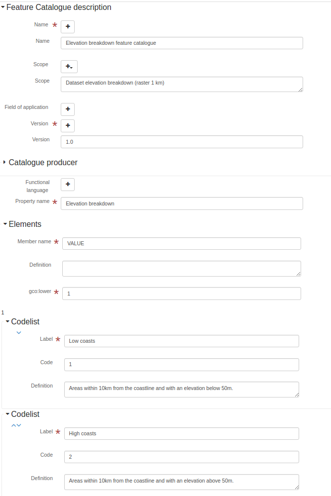
Metadata editor
This standard can be encoded using 3 view(s).
View: Simple (default)
This view is composed of1tab(s).
This view also allows to add the following element even if not in the current record:
Code (gfc:code)
Codelist (gfc:listedValue)
Tab: Simple (default)
This tab display elements from the XML metadata record.
Section: Feature Catalogue description
See:ref:iso19110-elem-gfc-FC_FeatureCatalogue-a4de444fdd9a6e86e8ba63bb96be363c
Name
Feature catalogue name- XPath:
/gfc:FC_FeatureCatalogue/gmx:name
See:ref:iso19110-elem-gmx-name-5ec0c4442ad2b94944636103e556d401
Name
Feature catalogue name- XPath:
/gfc:FC_FeatureCatalogue/gfc:name
See:ref:iso19110-elem-gfc-name-134285dc9b9a3268556039e2fe3f370e
Scope
Scope definition- XPath:
/gfc:FC_FeatureCatalogue/gmx:scope
See:ref:iso19110-elem-gmx-scope-14efac6982297b09ba1324e80138092f
Scope
Scope definition- XPath:
/gfc:FC_FeatureCatalogue/gfc:scope
See:ref:iso19110-elem-gfc-scope-4f044fce55b8e0b6dd0d77516ad9e66d
Field of application
Field of application- XPath:
/gfc:FC_FeatureCatalogue/gmx:fieldOfApplication
See:ref:iso19110-elem-gmx-fieldOfApplication-66508d1f139317e01e1decd095915428
Field of application
Field of application- XPath:
/gfc:FC_FeatureCatalogue/gfc:fieldOfApplication
See:ref:iso19110-elem-gfc-fieldOfApplication-548e0631e3ea92f7dd05ac533b6c14d2
Version
Catalogue version- XPath:
/gfc:FC_FeatureCatalogue/gmx:versionNumber
See:ref:iso19110-elem-gmx-versionNumber-075201f18225aec432b46c75a93589a2
Version
Catalogue version- XPath:
/gfc:FC_FeatureCatalogue/gfc:versionNumber
See:ref:iso19110-elem-gfc-versionNumber-d66ec9fd5c22c70a69dd2b759d66cc4f
Date
Catalogue date- XPath:
/gfc:FC_FeatureCatalogue/gmx:versionDate
See:ref:iso19110-elem-gmx-versionDate-6c27e2ee0b2daa4ab1aea9ef374bc08f
Catalogue producer
Catalogue responsible- XPath:
/gfc:FC_FeatureCatalogue/gfc:producer
See:ref:iso19110-elem-gfc-producer-5a13bfab8b07441bc9f9f71dcfdf7f6c
Functional language
- XPath:
/gfc:FC_FeatureCatalogue/gfc:functionalLanguage
See:ref:iso19110-elem-gfc-functionalLanguage-7a21d9c35ed9c400c40959ede97b8d76
Property description
Property description- XPath:
/gfc:FC_FeatureCatalogue/gfc:featureType
See:ref:iso19110-elem-gfc-featureType-d6099a684b15337451388dd46048c48f
- Type:
suggest
View: Full (advanced)
This view is composed of1tab(s).
Tab: Full (advanced)
This tab display elements from the XML metadata record and also provide controls to add all elements defined in the schema (XSD).
Section: Attribute table description
Attribute table descriptionSee:ref:iso19110-elem-gfc-FC_FeatureType-38ad06d5e87d9bf33d5f111e7bca0eb4
Section: Feature Catalogue description
See:ref:iso19110-elem-gfc-FC_FeatureCatalogue-a4de444fdd9a6e86e8ba63bb96be363c
View: XML (xml)
This view is composed of1tab(s).
Tab: XML (xml)
This tab display elements from the XML metadata record and also provide controls to add all elements defined in the schema (XSD).
Schema technical details
- Standard identifier:
iso19110
- Version:
1.0
- Schema location:
http://www.isotc211.org/2005/gfc http://www.isotc211.org/2005/gfc/gfc.xsd
- Schema namespaces:
- Schema detection mode:
elements (root)
- Schema detection elements:
gfc:FC_FeatureCatalogue
gfc:FC_FeatureType
Standard elements
List of all elements available in the standard.
Text
- Name:
gco:CharacterString
- Description:
Lower cardinality
- Name:
gco:lower
- Description:
<gco:lower xmlns:gfc="http://www.isotc211.org/2005/gfc"
           xmlns:xsi="http://www.w3.org/2001/XMLSchema-instance">
   <gco:Integer>1</gco:Integer>
</gco:lower>
Nil reason
- Name:
gco:nilReason
- Description:
Range
- Name:
gco:range
- Description:
<gco:range xmlns:gfc="http://www.isotc211.org/2005/gfc"
           xmlns:xsi="http://www.w3.org/2001/XMLSchema-instance">
   <gco:MultiplicityRange>
      <gco:lower>
         <gco:Integer>1</gco:Integer>
      </gco:lower>
      <gco:upper>
         <gco:UnlimitedInteger isInfinite="false" xsi:nil="false">1
                    </gco:UnlimitedInteger>
      </gco:upper>
   </gco:MultiplicityRange>
</gco:range>
Upper cardinality
- Name:
gco:upper
- Description:
<gco:upper xmlns:gfc="http://www.isotc211.org/2005/gfc"
           xmlns:xsi="http://www.w3.org/2001/XMLSchema-instance">
   <gco:UnlimitedInteger isInfinite="false" xsi:nil="false">1
                    </gco:UnlimitedInteger>
</gco:upper>
Affects value of
- Name:
gfc:affectsValueOf
- Description:
Aliases
- Name:
gfc:aliases
- Description:
Cardinalities
- Name:
gfc:cardinality
- Description:
<gfc:cardinality xmlns:gfc="http://www.isotc211.org/2005/gfc"
                 xmlns:xsi="http://www.w3.org/2001/XMLSchema-instance">
   <gco:Multiplicity>
      <gco:range>
         <gco:MultiplicityRange>
            <gco:lower>
               <gco:Integer>1</gco:Integer>
            </gco:lower>
            <gco:upper>
               <gco:UnlimitedInteger isInfinite="false" xsi:nil="false">1
                    </gco:UnlimitedInteger>
            </gco:upper>
         </gco:MultiplicityRange>
      </gco:range>
   </gco:Multiplicity>
</gfc:cardinality>
Elements
- Name:
gfc:carrierOfCharacteristics
- Description:
<gfc:carrierOfCharacteristics xmlns:gfc="http://www.isotc211.org/2005/gfc"
                              xmlns:xsi="http://www.w3.org/2001/XMLSchema-instance">
   <gfc:FC_FeatureAttribute>
      <gfc:memberName>
         <gco:LocalName>VALUE</gco:LocalName>
      </gfc:memberName>
      <gfc:definition>
         <gco:CharacterString/>
      </gfc:definition>
      <gfc:cardinality>
         <gco:Multiplicity>
            <gco:range>
               <gco:MultiplicityRange>
                  <gco:lower>
                     <gco:Integer>1</gco:Integer>
                  </gco:lower>
                  <gco:upper>
                     <gco:UnlimitedInteger isInfinite="false" xsi:nil="false">1
                    </gco:UnlimitedInteger>
                  </gco:upper>
               </gco:MultiplicityRange>
            </gco:range>
         </gco:Multiplicity>
      </gfc:cardinality>
      <gfc:featureType/>
      <gfc:valueMeasurementUnit>
         <gml:UnitDefinition xmlns:gml="http://www.opengis.net/gml" gml:id="unknown">
            <gml:description/>
            <gml:identifier codeSpace="unknown"/>
         </gml:UnitDefinition>
      </gfc:valueMeasurementUnit>
      <gfc:listedValue>
         <gfc:FC_ListedValue>
            <gfc:label>
               <gco:CharacterString>Low coasts</gco:CharacterString>
            </gfc:label>
            <gfc:code>
               <gco:CharacterString>1</gco:CharacterString>
            </gfc:code>
            <gfc:definition>
               <gco:CharacterString>Areas within 10km from the coastline and with an elevation
                  below 50m.
                </gco:CharacterString>
            </gfc:definition>
         </gfc:FC_ListedValue>
      </gfc:listedValue>
      <gfc:listedValue>
         <gfc:FC_ListedValue>
            <gfc:label>
               <gco:CharacterString>High coasts</gco:CharacterString>
            </gfc:label>
            <gfc:code>
               <gco:CharacterString>2</gco:CharacterString>
            </gfc:code>
            <gfc:definition>
               <gco:CharacterString>Areas within 10km from the coastline and with an elevation
                  above 50m.
                </gco:CharacterString>
            </gfc:definition>
         </gfc:FC_ListedValue>
      </gfc:listedValue>
      <gfc:listedValue>
         <gfc:FC_ListedValue>
            <gfc:label>
               <gco:CharacterString>Inlands</gco:CharacterString>
            </gfc:label>
            <gfc:code>
               <gco:CharacterString>3</gco:CharacterString>
            </gfc:code>
            <gfc:definition>
               <gco:CharacterString>Areas between 0 and 200 m outside the coastal strip.
                </gco:CharacterString>
            </gfc:definition>
         </gfc:FC_ListedValue>
      </gfc:listedValue>
      <gfc:listedValue>
         <gfc:FC_ListedValue>
            <gfc:label>
               <gco:CharacterString>Uplands</gco:CharacterString>
            </gfc:label>
            <gfc:code>
               <gco:CharacterString>4</gco:CharacterString>
            </gfc:code>
            <gfc:definition>
               <gco:CharacterString>Zones between 200 and 500 m plus the flat areas between 500 and
                  1000m.
                </gco:CharacterString>
            </gfc:definition>
         </gfc:FC_ListedValue>
      </gfc:listedValue>
      <gfc:listedValue>
         <gfc:FC_ListedValue>
            <gfc:label>
               <gco:CharacterString>Mountains</gco:CharacterString>
            </gfc:label>
            <gfc:code>
               <gco:CharacterString>5</gco:CharacterString>
            </gfc:code>
            <gfc:definition>
               <gco:CharacterString>Slopy areas between 500 and 1000m and all the areas over
                  1000m.
                </gco:CharacterString>
            </gfc:definition>
         </gfc:FC_ListedValue>
      </gfc:listedValue>
      <gfc:valueType>
         <gco:TypeName>
            <gco:aName>
               <gco:CharacterString>INTEGER</gco:CharacterString>
            </gco:aName>
         </gco:TypeName>
      </gfc:valueType>
   </gfc:FC_FeatureAttribute>
</gfc:carrierOfCharacteristics>
Code
- Name:
gfc:code
- Description:
Constrained by
- Name:
gfc:constrainedBy
- Description:
Definition
- Name:
gfc:definition
- Description:
Definition reference
- Name:
gfc:definitionReference
- Description:
Definition source
- Name:
gfc:definitionSource
- Description:
Description
- Name:
gfc:description
- Description:
Association role
- Name:
gfc:FC_AssociationRole
- Description:
Constraint
- Name:
gfc:FC_Constraint
- Description:
Feature association
- Name:
gfc:FC_FeatureAssociation
- Description:
Attribute
- Name:
gfc:FC_FeatureAttribute
- Description:
<gfc:FC_FeatureAttribute xmlns:gfc="http://www.isotc211.org/2005/gfc"
                         xmlns:xsi="http://www.w3.org/2001/XMLSchema-instance">
   <gfc:memberName>
      <gco:LocalName>VALUE</gco:LocalName>
   </gfc:memberName>
   <gfc:definition>
      <gco:CharacterString/>
   </gfc:definition>
   <gfc:cardinality>
      <gco:Multiplicity>
         <gco:range>
            <gco:MultiplicityRange>
               <gco:lower>
                  <gco:Integer>1</gco:Integer>
               </gco:lower>
               <gco:upper>
                  <gco:UnlimitedInteger isInfinite="false" xsi:nil="false">1
                    </gco:UnlimitedInteger>
               </gco:upper>
            </gco:MultiplicityRange>
         </gco:range>
      </gco:Multiplicity>
   </gfc:cardinality>
   <gfc:featureType/>
   <gfc:valueMeasurementUnit>
      <gml:UnitDefinition xmlns:gml="http://www.opengis.net/gml" gml:id="unknown">
         <gml:description/>
         <gml:identifier codeSpace="unknown"/>
      </gml:UnitDefinition>
   </gfc:valueMeasurementUnit>
   <gfc:listedValue>
      <gfc:FC_ListedValue>
         <gfc:label>
            <gco:CharacterString>Low coasts</gco:CharacterString>
         </gfc:label>
         <gfc:code>
            <gco:CharacterString>1</gco:CharacterString>
         </gfc:code>
         <gfc:definition>
            <gco:CharacterString>Areas within 10km from the coastline and with an elevation
                  below 50m.
                </gco:CharacterString>
         </gfc:definition>
      </gfc:FC_ListedValue>
   </gfc:listedValue>
   <gfc:listedValue>
      <gfc:FC_ListedValue>
         <gfc:label>
            <gco:CharacterString>High coasts</gco:CharacterString>
         </gfc:label>
         <gfc:code>
            <gco:CharacterString>2</gco:CharacterString>
         </gfc:code>
         <gfc:definition>
            <gco:CharacterString>Areas within 10km from the coastline and with an elevation
                  above 50m.
                </gco:CharacterString>
         </gfc:definition>
      </gfc:FC_ListedValue>
   </gfc:listedValue>
   <gfc:listedValue>
      <gfc:FC_ListedValue>
         <gfc:label>
            <gco:CharacterString>Inlands</gco:CharacterString>
         </gfc:label>
         <gfc:code>
            <gco:CharacterString>3</gco:CharacterString>
         </gfc:code>
         <gfc:definition>
            <gco:CharacterString>Areas between 0 and 200 m outside the coastal strip.
                </gco:CharacterString>
         </gfc:definition>
      </gfc:FC_ListedValue>
   </gfc:listedValue>
   <gfc:listedValue>
      <gfc:FC_ListedValue>
         <gfc:label>
            <gco:CharacterString>Uplands</gco:CharacterString>
         </gfc:label>
         <gfc:code>
            <gco:CharacterString>4</gco:CharacterString>
         </gfc:code>
         <gfc:definition>
            <gco:CharacterString>Zones between 200 and 500 m plus the flat areas between 500 and
                  1000m.
                </gco:CharacterString>
         </gfc:definition>
      </gfc:FC_ListedValue>
   </gfc:listedValue>
   <gfc:listedValue>
      <gfc:FC_ListedValue>
         <gfc:label>
            <gco:CharacterString>Mountains</gco:CharacterString>
         </gfc:label>
         <gfc:code>
            <gco:CharacterString>5</gco:CharacterString>
         </gfc:code>
         <gfc:definition>
            <gco:CharacterString>Slopy areas between 500 and 1000m and all the areas over
                  1000m.
                </gco:CharacterString>
         </gfc:definition>
      </gfc:FC_ListedValue>
   </gfc:listedValue>
   <gfc:valueType>
      <gco:TypeName>
         <gco:aName>
            <gco:CharacterString>INTEGER</gco:CharacterString>
         </gco:aName>
      </gco:TypeName>
   </gfc:valueType>
</gfc:FC_FeatureAttribute>
Feature Catalogue description
- Name:
gfc:FC_FeatureCatalogue
- Description:
<gfc:FC_FeatureCatalogue xmlns:gfc="http://www.isotc211.org/2005/gfc"
                         uuid="411cd05b-9a79-45f2-b39f-0b344a9f35af"
                         xsi:schemaLocation="http://www.isotc211.org/2005/gfc http://www.isotc211.org/2005/gfc/gfc.xsd">
   <gfc:name>
      <gco:CharacterString>Elevation breakdown feature catalogue</gco:CharacterString>
   </gfc:name>
   <gfc:scope>
      <gco:CharacterString>Dataset elevation breakdown (raster 1 km)</gco:CharacterString>
   </gfc:scope>
   <gfc:versionNumber>
      <gco:CharacterString>1.0</gco:CharacterString>
   </gfc:versionNumber>
   <gfc:versionDate>
      <gco:DateTime>2012-11-05T10:56:11</gco:DateTime>
   </gfc:versionDate>
   <gfc:producer>
      <gmd:CI_ResponsibleParty>
         <gmd:individualName>
            <gco:CharacterString>European Environment Agency</gco:CharacterString>
         </gmd:individualName>
         <gmd:organisationName>
            <gco:CharacterString/>
         </gmd:organisationName>
         <gmd:positionName>
            <gco:CharacterString/>
         </gmd:positionName>
         <gmd:contactInfo>
            <gmd:CI_Contact>
               <gmd:address>
                  <gmd:CI_Address>
                     <gmd:deliveryPoint>
                        <gco:CharacterString>Kongens Nytorv 6</gco:CharacterString>
                     </gmd:deliveryPoint>
                     <gmd:city>
                        <gco:CharacterString>Copenhagen</gco:CharacterString>
                     </gmd:city>
                     <gmd:administrativeArea>
                        <gco:CharacterString>K</gco:CharacterString>
                     </gmd:administrativeArea>
                     <gmd:postalCode>
                        <gco:CharacterString>1050</gco:CharacterString>
                     </gmd:postalCode>
                     <gmd:country>
                        <gco:CharacterString>Denmark</gco:CharacterString>
                     </gmd:country>
                     <gmd:electronicMailAddress>
                        <gco:CharacterString>mauro.michielon@eea.europa.eu</gco:CharacterString>
                     </gmd:electronicMailAddress>
                  </gmd:CI_Address>
               </gmd:address>
            </gmd:CI_Contact>
         </gmd:contactInfo>
         <gmd:role>
            <gmd:CI_RoleCode codeListValue="pointOfContact" codeList="CI_RoleCode"/>
         </gmd:role>
      </gmd:CI_ResponsibleParty>
   </gfc:producer>
   <gfc:featureType>
      <gfc:FC_FeatureType>
         <gfc:typeName>
            <gco:LocalName>Elevation breakdown</gco:LocalName>
         </gfc:typeName>
         <gfc:definition>
            <gco:CharacterString>The Elevation breakdown is used to allocate Land cover changes into
          homogeneous areas as function of height, slope and distance to the sea.
        </gco:CharacterString>
         </gfc:definition>
         <gfc:isAbstract>
            <gco:Boolean>false</gco:Boolean>
         </gfc:isAbstract>
         <gfc:featureCatalogue/>
         <gfc:carrierOfCharacteristics>
            <gfc:FC_FeatureAttribute>
               <gfc:memberName>
                  <gco:LocalName>VALUE</gco:LocalName>
               </gfc:memberName>
               <gfc:definition>
                  <gco:CharacterString/>
               </gfc:definition>
               <gfc:cardinality>
                  <gco:Multiplicity>
                     <gco:range>
                        <gco:MultiplicityRange>
                           <gco:lower>
                              <gco:Integer>1</gco:Integer>
                           </gco:lower>
                           <gco:upper>
                              <gco:UnlimitedInteger isInfinite="false" xsi:nil="false">1
                    </gco:UnlimitedInteger>
                           </gco:upper>
                        </gco:MultiplicityRange>
                     </gco:range>
                  </gco:Multiplicity>
               </gfc:cardinality>
               <gfc:featureType/>
               <gfc:valueMeasurementUnit>
                  <gml:UnitDefinition xmlns:gml="http://www.opengis.net/gml" gml:id="unknown">
                     <gml:description/>
                     <gml:identifier codeSpace="unknown"/>
                  </gml:UnitDefinition>
               </gfc:valueMeasurementUnit>
               <gfc:listedValue>
                  <gfc:FC_ListedValue>
                     <gfc:label>
                        <gco:CharacterString>Low coasts</gco:CharacterString>
                     </gfc:label>
                     <gfc:code>
                        <gco:CharacterString>1</gco:CharacterString>
                     </gfc:code>
                     <gfc:definition>
                        <gco:CharacterString>Areas within 10km from the coastline and with an elevation
                  below 50m.
                </gco:CharacterString>
                     </gfc:definition>
                  </gfc:FC_ListedValue>
               </gfc:listedValue>
               <gfc:listedValue>
                  <gfc:FC_ListedValue>
                     <gfc:label>
                        <gco:CharacterString>High coasts</gco:CharacterString>
                     </gfc:label>
                     <gfc:code>
                        <gco:CharacterString>2</gco:CharacterString>
                     </gfc:code>
                     <gfc:definition>
                        <gco:CharacterString>Areas within 10km from the coastline and with an elevation
                  above 50m.
                </gco:CharacterString>
                     </gfc:definition>
                  </gfc:FC_ListedValue>
               </gfc:listedValue>
               <gfc:listedValue>
                  <gfc:FC_ListedValue>
                     <gfc:label>
                        <gco:CharacterString>Inlands</gco:CharacterString>
                     </gfc:label>
                     <gfc:code>
                        <gco:CharacterString>3</gco:CharacterString>
                     </gfc:code>
                     <gfc:definition>
                        <gco:CharacterString>Areas between 0 and 200 m outside the coastal strip.
                </gco:CharacterString>
                     </gfc:definition>
                  </gfc:FC_ListedValue>
               </gfc:listedValue>
               <gfc:listedValue>
                  <gfc:FC_ListedValue>
                     <gfc:label>
                        <gco:CharacterString>Uplands</gco:CharacterString>
                     </gfc:label>
                     <gfc:code>
                        <gco:CharacterString>4</gco:CharacterString>
                     </gfc:code>
                     <gfc:definition>
                        <gco:CharacterString>Zones between 200 and 500 m plus the flat areas between 500 and
                  1000m.
                </gco:CharacterString>
                     </gfc:definition>
                  </gfc:FC_ListedValue>
               </gfc:listedValue>
               <gfc:listedValue>
                  <gfc:FC_ListedValue>
                     <gfc:label>
                        <gco:CharacterString>Mountains</gco:CharacterString>
                     </gfc:label>
                     <gfc:code>
                        <gco:CharacterString>5</gco:CharacterString>
                     </gfc:code>
                     <gfc:definition>
                        <gco:CharacterString>Slopy areas between 500 and 1000m and all the areas over
                  1000m.
                </gco:CharacterString>
                     </gfc:definition>
                  </gfc:FC_ListedValue>
               </gfc:listedValue>
               <gfc:valueType>
                  <gco:TypeName>
                     <gco:aName>
                        <gco:CharacterString>INTEGER</gco:CharacterString>
                     </gco:aName>
                  </gco:TypeName>
               </gfc:valueType>
            </gfc:FC_FeatureAttribute>
         </gfc:carrierOfCharacteristics>
      </gfc:FC_FeatureType>
   </gfc:featureType>
</gfc:FC_FeatureCatalogue>
Feature operation
- Name:
gfc:FC_FeatureOperation
- Description:
Attribute table description
- Name:
gfc:FC_FeatureType
- Description:
<gfc:FC_FeatureType xmlns:gfc="http://www.isotc211.org/2005/gfc"
                    xmlns:xsi="http://www.w3.org/2001/XMLSchema-instance">
   <gfc:typeName>
      <gco:LocalName>Elevation breakdown</gco:LocalName>
   </gfc:typeName>
   <gfc:definition>
      <gco:CharacterString>The Elevation breakdown is used to allocate Land cover changes into
          homogeneous areas as function of height, slope and distance to the sea.
        </gco:CharacterString>
   </gfc:definition>
   <gfc:isAbstract>
      <gco:Boolean>false</gco:Boolean>
   </gfc:isAbstract>
   <gfc:featureCatalogue/>
   <gfc:carrierOfCharacteristics>
      <gfc:FC_FeatureAttribute>
         <gfc:memberName>
            <gco:LocalName>VALUE</gco:LocalName>
         </gfc:memberName>
         <gfc:definition>
            <gco:CharacterString/>
         </gfc:definition>
         <gfc:cardinality>
            <gco:Multiplicity>
               <gco:range>
                  <gco:MultiplicityRange>
                     <gco:lower>
                        <gco:Integer>1</gco:Integer>
                     </gco:lower>
                     <gco:upper>
                        <gco:UnlimitedInteger isInfinite="false" xsi:nil="false">1
                    </gco:UnlimitedInteger>
                     </gco:upper>
                  </gco:MultiplicityRange>
               </gco:range>
            </gco:Multiplicity>
         </gfc:cardinality>
         <gfc:featureType/>
         <gfc:valueMeasurementUnit>
            <gml:UnitDefinition xmlns:gml="http://www.opengis.net/gml" gml:id="unknown">
               <gml:description/>
               <gml:identifier codeSpace="unknown"/>
            </gml:UnitDefinition>
         </gfc:valueMeasurementUnit>
         <gfc:listedValue>
            <gfc:FC_ListedValue>
               <gfc:label>
                  <gco:CharacterString>Low coasts</gco:CharacterString>
               </gfc:label>
               <gfc:code>
                  <gco:CharacterString>1</gco:CharacterString>
               </gfc:code>
               <gfc:definition>
                  <gco:CharacterString>Areas within 10km from the coastline and with an elevation
                  below 50m.
                </gco:CharacterString>
               </gfc:definition>
            </gfc:FC_ListedValue>
         </gfc:listedValue>
         <gfc:listedValue>
            <gfc:FC_ListedValue>
               <gfc:label>
                  <gco:CharacterString>High coasts</gco:CharacterString>
               </gfc:label>
               <gfc:code>
                  <gco:CharacterString>2</gco:CharacterString>
               </gfc:code>
               <gfc:definition>
                  <gco:CharacterString>Areas within 10km from the coastline and with an elevation
                  above 50m.
                </gco:CharacterString>
               </gfc:definition>
            </gfc:FC_ListedValue>
         </gfc:listedValue>
         <gfc:listedValue>
            <gfc:FC_ListedValue>
               <gfc:label>
                  <gco:CharacterString>Inlands</gco:CharacterString>
               </gfc:label>
               <gfc:code>
                  <gco:CharacterString>3</gco:CharacterString>
               </gfc:code>
               <gfc:definition>
                  <gco:CharacterString>Areas between 0 and 200 m outside the coastal strip.
                </gco:CharacterString>
               </gfc:definition>
            </gfc:FC_ListedValue>
         </gfc:listedValue>
         <gfc:listedValue>
            <gfc:FC_ListedValue>
               <gfc:label>
                  <gco:CharacterString>Uplands</gco:CharacterString>
               </gfc:label>
               <gfc:code>
                  <gco:CharacterString>4</gco:CharacterString>
               </gfc:code>
               <gfc:definition>
                  <gco:CharacterString>Zones between 200 and 500 m plus the flat areas between 500 and
                  1000m.
                </gco:CharacterString>
               </gfc:definition>
            </gfc:FC_ListedValue>
         </gfc:listedValue>
         <gfc:listedValue>
            <gfc:FC_ListedValue>
               <gfc:label>
                  <gco:CharacterString>Mountains</gco:CharacterString>
               </gfc:label>
               <gfc:code>
                  <gco:CharacterString>5</gco:CharacterString>
               </gfc:code>
               <gfc:definition>
                  <gco:CharacterString>Slopy areas between 500 and 1000m and all the areas over
                  1000m.
                </gco:CharacterString>
               </gfc:definition>
            </gfc:FC_ListedValue>
         </gfc:listedValue>
         <gfc:valueType>
            <gco:TypeName>
               <gco:aName>
                  <gco:CharacterString>INTEGER</gco:CharacterString>
               </gco:aName>
            </gco:TypeName>
         </gfc:valueType>
      </gfc:FC_FeatureAttribute>
   </gfc:carrierOfCharacteristics>
</gfc:FC_FeatureType>
Heritance relation
- Name:
gfc:FC_InheritanceRelation
- Description:
Codelist
- Name:
gfc:FC_ListedValue
- Description:
Role type
- Name:
gfc:FC_RoleType
- Description:
Feature catalogue
- Name:
gfc:featureCatalogue
- Description:
<gfc:featureCatalogue xmlns:gfc="http://www.isotc211.org/2005/gfc"
                      xmlns:xsi="http://www.w3.org/2001/XMLSchema-instance"/>
Property description
- Name:
gfc:featureType
- Description:
Field of application
- Name:
gfc:fieldOfApplication
- Description:
Formal definition
- Name:
gfc:formalDefinition
- Description:
Functional language
- Name:
gfc:functionalLanguage
- Description:
Inherits from
- Name:
gfc:inheritsFrom
- Description:
Inherits to
- Name:
gfc:inheritsTo
- Description:
Abstract
- Name:
gfc:isAbstract
- Description:
<gfc:isAbstract xmlns:gfc="http://www.isotc211.org/2005/gfc"
                xmlns:xsi="http://www.w3.org/2001/XMLSchema-instance">
   <gco:Boolean>false</gco:Boolean>
</gfc:isAbstract>
Is ordered
- Name:
gfc:isOrdered
- Description:
Label
- Name:
gfc:label
- Description:
Codelist
- Name:
gfc:listedValue
- Description:
Member name
- Name:
gfc:memberName
- Description:
<gfc:memberName xmlns:gfc="http://www.isotc211.org/2005/gfc"
                xmlns:xsi="http://www.w3.org/2001/XMLSchema-instance">
   <gco:LocalName>VALUE</gco:LocalName>
</gfc:memberName>
Name
- Name:
gfc:name
- Description:
<gfc:name xmlns:gfc="http://www.isotc211.org/2005/gfc"
          xmlns:xsi="http://www.w3.org/2001/XMLSchema-instance">
   <gco:CharacterString>Elevation breakdown feature catalogue</gco:CharacterString>
</gfc:name>
Observes value of
- Name:
gfc:observesValueOf
- Description:
Catalogue producer
- Name:
gfc:producer
- Description:
<gfc:producer xmlns:gfc="http://www.isotc211.org/2005/gfc"
              xmlns:xsi="http://www.w3.org/2001/XMLSchema-instance">
   <gmd:CI_ResponsibleParty>
      <gmd:individualName>
         <gco:CharacterString>European Environment Agency</gco:CharacterString>
      </gmd:individualName>
      <gmd:organisationName>
         <gco:CharacterString/>
      </gmd:organisationName>
      <gmd:positionName>
         <gco:CharacterString/>
      </gmd:positionName>
      <gmd:contactInfo>
         <gmd:CI_Contact>
            <gmd:address>
               <gmd:CI_Address>
                  <gmd:deliveryPoint>
                     <gco:CharacterString>Kongens Nytorv 6</gco:CharacterString>
                  </gmd:deliveryPoint>
                  <gmd:city>
                     <gco:CharacterString>Copenhagen</gco:CharacterString>
                  </gmd:city>
                  <gmd:administrativeArea>
                     <gco:CharacterString>K</gco:CharacterString>
                  </gmd:administrativeArea>
                  <gmd:postalCode>
                     <gco:CharacterString>1050</gco:CharacterString>
                  </gmd:postalCode>
                  <gmd:country>
                     <gco:CharacterString>Denmark</gco:CharacterString>
                  </gmd:country>
                  <gmd:electronicMailAddress>
                     <gco:CharacterString>mauro.michielon@eea.europa.eu</gco:CharacterString>
                  </gmd:electronicMailAddress>
               </gmd:CI_Address>
            </gmd:address>
         </gmd:CI_Contact>
      </gmd:contactInfo>
      <gmd:role>
         <gmd:CI_RoleCode codeListValue="pointOfContact" codeList="CI_RoleCode"/>
      </gmd:role>
   </gmd:CI_ResponsibleParty>
</gfc:producer>
Relation
- Name:
gfc:relation
- Description:
Role name
- Name:
gfc:roleName
- Description:
Role type
- Name:
gfc:roleType
- Description:
Scope
- Name:
gfc:scope
- Description:
<gfc:scope xmlns:gfc="http://www.isotc211.org/2005/gfc"
           xmlns:xsi="http://www.w3.org/2001/XMLSchema-instance">
   <gco:CharacterString>Dataset elevation breakdown (raster 1 km)</gco:CharacterString>
</gfc:scope>
Signature
- Name:
gfc:signature
- Description:
Triggered by value of
- Name:
gfc:triggeredByValueOf
- Description:
Type
- Name:
gfc:type
- Description:
Property name
- Name:
gfc:typeName
- Description:
<gfc:typeName xmlns:gfc="http://www.isotc211.org/2005/gfc"
              xmlns:xsi="http://www.w3.org/2001/XMLSchema-instance">
   <gco:LocalName>Elevation breakdown</gco:LocalName>
</gfc:typeName>
Unique instance
- Name:
gfc:uniqueInstance
- Description:
Value measurement unit
- Name:
gfc:valueMeasurementUnit
- Description:
<gfc:valueMeasurementUnit xmlns:gfc="http://www.isotc211.org/2005/gfc"
                          xmlns:xsi="http://www.w3.org/2001/XMLSchema-instance">
   <gml:UnitDefinition xmlns:gml="http://www.opengis.net/gml" gml:id="unknown">
      <gml:description/>
      <gml:identifier codeSpace="unknown"/>
   </gml:UnitDefinition>
</gfc:valueMeasurementUnit>
Value type
- Name:
gfc:valueType
- Description:
<gfc:valueType xmlns:gfc="http://www.isotc211.org/2005/gfc"
               xmlns:xsi="http://www.w3.org/2001/XMLSchema-instance">
   <gco:TypeName>
      <gco:aName>
         <gco:CharacterString>INTEGER</gco:CharacterString>
      </gco:aName>
   </gco:TypeName>
</gfc:valueType>
Date
- Name:
gfc:versionDate
- Description:
<gfc:versionDate xmlns:gfc="http://www.isotc211.org/2005/gfc"
                 xmlns:xsi="http://www.w3.org/2001/XMLSchema-instance">
   <gco:DateTime>2012-11-05T10:56:11</gco:DateTime>
</gfc:versionDate>
Version
- Name:
gfc:versionNumber
- Description:
<gfc:versionNumber xmlns:gfc="http://www.isotc211.org/2005/gfc"
                   xmlns:xsi="http://www.w3.org/2001/XMLSchema-instance">
   <gco:CharacterString>1.0</gco:CharacterString>
</gfc:versionNumber>
Responsible party
- Name:
gmd:CI_ResponsibleParty
- Description:
<gmd:CI_ResponsibleParty xmlns:gfc="http://www.isotc211.org/2005/gfc"
                         xmlns:xsi="http://www.w3.org/2001/XMLSchema-instance">
   <gmd:individualName>
      <gco:CharacterString>European Environment Agency</gco:CharacterString>
   </gmd:individualName>
   <gmd:organisationName>
      <gco:CharacterString/>
   </gmd:organisationName>
   <gmd:positionName>
      <gco:CharacterString/>
   </gmd:positionName>
   <gmd:contactInfo>
      <gmd:CI_Contact>
         <gmd:address>
            <gmd:CI_Address>
               <gmd:deliveryPoint>
                  <gco:CharacterString>Kongens Nytorv 6</gco:CharacterString>
               </gmd:deliveryPoint>
               <gmd:city>
                  <gco:CharacterString>Copenhagen</gco:CharacterString>
               </gmd:city>
               <gmd:administrativeArea>
                  <gco:CharacterString>K</gco:CharacterString>
               </gmd:administrativeArea>
               <gmd:postalCode>
                  <gco:CharacterString>1050</gco:CharacterString>
               </gmd:postalCode>
               <gmd:country>
                  <gco:CharacterString>Denmark</gco:CharacterString>
               </gmd:country>
               <gmd:electronicMailAddress>
                  <gco:CharacterString>mauro.michielon@eea.europa.eu</gco:CharacterString>
               </gmd:electronicMailAddress>
            </gmd:CI_Address>
         </gmd:address>
      </gmd:CI_Contact>
   </gmd:contactInfo>
   <gmd:role>
      <gmd:CI_RoleCode codeListValue="pointOfContact" codeList="CI_RoleCode"/>
   </gmd:role>
</gmd:CI_ResponsibleParty>
Responsible party
- Name:
gmd:responsibleParty
- Description:
Anchor
- Name:
gmx:Anchor
- Description:
Field of application
- Name:
gmx:fieldOfApplication
- Description:
File name
- Name:
gmx:FileName
- Description:
Name
- Name:
gmx:name
- Description:
Scope
- Name:
gmx:scope
- Description:
Date
- Name:
gmx:versionDate
- Description:
Version
- Name:
gmx:versionNumber
- Description:
Standard codelists
List of all codelists available in the standard.
No codelist defined.