Geographic information – Metadata (iso19139:2007) (iso19139)
ISO 19115 defines the schema required for describing geographic information and services by means of metadata. It provides information about the identification, the extent, the quality, the spatial and temporal aspects, the content, the spatial reference, the portrayal, distribution, and other properties of digital geographic data and services.
ISO 19115 is applicable to:
the cataloguing of all types of resources, clearinghouse activities, and the full description of datasets and services;
geographic services, geographic datasets, dataset series, and individual geographic features and feature properties.
ISO 19115 defines:
mandatory and conditional metadata sections, metadata entities, and metadata elements;
the minimum set of metadata required to serve most metadata applications (data discovery, determining data fitness for use, data access, data transfer, and use of digital data and services);
optional metadata elements to allow for a more extensive standard description of resources, if required;
a method for extending metadata to fit specialized needs.
Though ISO 19115 is applicable to digital data and services, its principles can be extended to many other types of resources such as maps, charts, and textual documents as well as non-geographic data. Certain conditional metadata elements might not apply to these other forms of data.
More details:https://www.iso.org/iso/home/store/catalogue_tc/catalogue_detail.htm?csnumber=53798
Metadata editor
This standard can be encoded using 3 view(s).
View: Simple (default)
This view is composed of1tab(s).
This view also allows to add the following element even if not in the current record:
Descriptive keywords (gmd:descriptiveKeywords)
Keyword (gmd:keyword)
Spatial resolution (gmd:spatialResolution)
Point of contact (gmd:pointOfContact)
Distributor (gmd:distributor)
Distribution format (gmd:distributionFormat)
Contact (gmd:contact)
Processor (gmd:processor)
Topic category (gmd:topicCategory)
Parameters (srv:parameters)
Tab: Simple (default)
This tab display elements from the XML metadata record.
Section: Identification info
Basic information about the resource(s) to which the metadata appliesSee:ref:iso19139-elem-gmd-identificationInfo-4fe68a205ff13feeccf0b58e08f39472
Section: Reference System Information
Description of the spatial and temporal reference systems used in the datasetSee:ref:iso19139-elem-gmd-referenceSystemInfo-c7702a2e8ac03097e306ab3a02406765
Section: Spatial representation info
Digital representation of spatial information in the datasetSee:ref:iso19139-elem-gmd-spatialRepresentationInfo-f93705d4877ccd4c41819cc79677d6f2
Section: Distribution Information
Provides information about the distributor of and options for obtaining the resource(s)See:ref:iso19139-elem-gmd-distributionInfo-3bddab6fda29c9ebd6f0ece68843fcff
Section: Data quality info
Provides overall assessment of quality of a resource(s)See:ref:iso19139-elem-gmd-dataQualityInfo-9a53c25e2dacf5a7ab0aa1d155efc3dc
Section: Content Information
Provides information about the feature catalogue and describes the coverage and image data characteristicsSee:ref:iso19139-elem-gmd-contentInfo-da18cd6a5e91bae67187adc15ff47622
Section: Metadata
Root entity which defines metadata about a resource or resourcesSee:ref:iso19139-elem-gmd-MD_Metadata-c2690d5de6984085623477c3bdc3275b
File identifier
Unique identifier for this metadata file- XPath:
/gmd:MD_Metadata/gmd:fileIdentifier
See:ref:iso19139-elem-gmd-fileIdentifier-353be7794d17e5435ce2fe57d91966ba
Metadata language
Language used for documenting metadata- XPath:
/gmd:MD_Metadata/gmd:language
See:ref:iso19139-elem-gmd-language-98a1fec5ea30c100ef63f1ca4bd6dbdb
Character set
Full name of the character coding standard used for the metadata set- XPath:
/gmd:MD_Metadata/gmd:characterSet
See:ref:iso19139-elem-gmd-characterSet-351330c9787387f916fed1143727215b
Parent identifier
File identifier of the metadata to which this metadata is a subset (child)- XPath:
/gmd:MD_Metadata/gmd:parentIdentifier
See:ref:iso19139-elem-gmd-parentIdentifier-e660d48fcd79782e330d99a6eee272bc
Hierarchy level
Scope to which the metadata applies (see annex H for more information about metadata hierarchy levels)- XPath:
/gmd:MD_Metadata/gmd:hierarchyLevel
See:ref:iso19139-elem-gmd-hierarchyLevel-2b6d53b433d8f9c0cc58606d27eecc17
Hierarchy level name
Name of the hierarchy levels for which the metadata is provided- XPath:
/gmd:MD_Metadata/gmd:hierarchyLevelName
See:ref:iso19139-elem-gmd-hierarchyLevelName-1c79276b0501d07055d7480b292899f0
Date stamp
Date that the metadata was created (YYYY-MM-DDThh:mm:ss)- XPath:
/gmd:MD_Metadata/gmd:dateStamp
See:ref:iso19139-elem-gmd-dateStamp-ee89eb65741d89aef14d153887f60948
Metadata standard name
Name of the metadata standard (including profile name) used- XPath:
/gmd:MD_Metadata/gmd:metadataStandardName
See:ref:iso19139-elem-gmd-metadataStandardName-1e8d324f913f2da08b656d26e73e994d
Metadata standard version
Version (profile) of the metadata standard used- XPath:
/gmd:MD_Metadata/gmd:metadataStandardVersion
See:ref:iso19139-elem-gmd-metadataStandardVersion-ab0dd515a6ca9c890bc32d3615cd427f
Contact
Party responsible for the metadata information- XPath:
/gmd:MD_Metadata/gmd:contact
See:ref:iso19139-elem-gmd-contact-1a17bee429a4ae3c87f4026bd2da8005
Dataset URI
Uniformed Resource Identifier (URI) of the dataset to which the metadata appliesUniformed Resource Identifier (URI) of the dataset to which the metadata applies. This link refers direct to the machine-readable dataset.- XPath:
/gmd:MD_Metadata/gmd:dataSetURI
See:ref:iso19139-elem-gmd-dataSetURI-8e14b3e6d98f92a9356ba2f3ba1ee982
Other language
Use this section to define other metadata language (multilingual metadata).- XPath:
/gmd:MD_Metadata/gmd:locale
See:ref:iso19139-elem-gmd-locale-826113f1d130f65f95c78f6b16227c4b
Series
Information about the series, or aggregate dataset, of which the dataset is a part- XPath:
/gmd:MD_Metadata/gmd:series
See:ref:iso19139-elem-gmd-series-98524248b047e1a31966f4fc05c765fb
Describes
Describes- XPath:
/gmd:MD_Metadata/gmd:describes
See:ref:iso19139-elem-gmd-describes-ea7ef755fceda2ec8b1bf4486f5572bf
PropertyType
PropertyType- XPath:
/gmd:MD_Metadata/gmd:propertyType
See:ref:iso19139-elem-gmd-propertyType-12fff0b8b43529f0300c32a5e13c9f89
Feature type
Subset of feature types from cited feature catalogue occurring in data- XPath:
/gmd:MD_Metadata/gmd:featureType
See:ref:iso19139-elem-gmd-featureType-1a7ddaf6d70b2bca513bbb097769f7a5
Feature attribute
- XPath:
/gmd:MD_Metadata/gmd:featureAttribute
See:ref:iso19139-elem-gmd-featureAttribute-ed65880b0d966b5862d0d434b26fd36b
View: Full (advanced)
This view is composed of11tab(s).
Tab: Identification (identificationInfo)
This tab display elements from the XML metadata record and also provide controls to add all elements defined in the schema (XSD).
Section: Identification info
Basic information about the resource(s) to which the metadata appliesSee:ref:iso19139-elem-gmd-identificationInfo-4fe68a205ff13feeccf0b58e08f39472
Tab: Distribution (distributionInfo)
This tab display elements from the XML metadata record and also provide controls to add all elements defined in the schema (XSD).
Section: Distribution Information
Provides information about the distributor of and options for obtaining the resource(s)See:ref:iso19139-elem-gmd-distributionInfo-3bddab6fda29c9ebd6f0ece68843fcff
Tab: Quality (dataQualityInfo)
This tab display elements from the XML metadata record and also provide controls to add all elements defined in the schema (XSD).
Section: Data quality info
Provides overall assessment of quality of a resource(s)See:ref:iso19139-elem-gmd-dataQualityInfo-9a53c25e2dacf5a7ab0aa1d155efc3dc
Tab: Spatial rep. (spatialRepresentationInfo)
This tab display elements from the XML metadata record and also provide controls to add all elements defined in the schema (XSD).
Section: Spatial representation info
Digital representation of spatial information in the datasetSee:ref:iso19139-elem-gmd-spatialRepresentationInfo-f93705d4877ccd4c41819cc79677d6f2
Tab: Ref. system (referenceSystemInfo)
This tab display elements from the XML metadata record and also provide controls to add all elements defined in the schema (XSD).
Section: Reference System Information
Description of the spatial and temporal reference systems used in the datasetSee:ref:iso19139-elem-gmd-referenceSystemInfo-c7702a2e8ac03097e306ab3a02406765
Tab: Content (contentInfo)
This tab display elements from the XML metadata record and also provide controls to add all elements defined in the schema (XSD).
Section: Content Information
Provides information about the feature catalogue and describes the coverage and image data characteristicsSee:ref:iso19139-elem-gmd-contentInfo-da18cd6a5e91bae67187adc15ff47622
Tab: Portrayal (portrayalCatalogueInfo)
This tab display elements from the XML metadata record and also provide controls to add all elements defined in the schema (XSD).
Section: Portrayal catalogue info
Provides information about the catalogue of rules defined for the portrayal of a resource(s)See:ref:iso19139-elem-gmd-portrayalCatalogueInfo-0a09defe8c7ca8431460b5690da9a52d
Tab: Metadata (metadata)
This tab display elements from the XML metadata record and also provide controls to add all elements defined in the schema (XSD).
Section: Metadata
File identifier
Unique identifier for this metadata file- XPath:
/gmd:MD_Metadata/gmd:fileIdentifier
See:ref:iso19139-elem-gmd-fileIdentifier-353be7794d17e5435ce2fe57d91966ba
Metadata language
Language used for documenting metadata- XPath:
/gmd:MD_Metadata/gmd:language
See:ref:iso19139-elem-gmd-language-98a1fec5ea30c100ef63f1ca4bd6dbdb
Other language
Use this section to define other metadata language (multilingual metadata).- XPath:
/gmd:MD_Metadata/gmd:locale
See:ref:iso19139-elem-gmd-locale-826113f1d130f65f95c78f6b16227c4b
Character set
Full name of the character coding standard used for the metadata set- XPath:
/gmd:MD_Metadata/gmd:characterSet
See:ref:iso19139-elem-gmd-characterSet-351330c9787387f916fed1143727215b
Parent identifier
File identifier of the metadata to which this metadata is a subset (child)- XPath:
/gmd:MD_Metadata/gmd:parentIdentifier
See:ref:iso19139-elem-gmd-parentIdentifier-e660d48fcd79782e330d99a6eee272bc
Hierarchy level
Scope to which the metadata applies (see annex H for more information about metadata hierarchy levels)- XPath:
/gmd:MD_Metadata/gmd:hierarchyLevel
See:ref:iso19139-elem-gmd-hierarchyLevel-2b6d53b433d8f9c0cc58606d27eecc17
Hierarchy level name
Name of the hierarchy levels for which the metadata is provided- XPath:
/gmd:MD_Metadata/gmd:hierarchyLevelName
See:ref:iso19139-elem-gmd-hierarchyLevelName-1c79276b0501d07055d7480b292899f0
Date stamp
Date that the metadata was created (YYYY-MM-DDThh:mm:ss)- XPath:
/gmd:MD_Metadata/gmd:dateStamp
See:ref:iso19139-elem-gmd-dateStamp-ee89eb65741d89aef14d153887f60948
Metadata standard name
Name of the metadata standard (including profile name) used- XPath:
/gmd:MD_Metadata/gmd:metadataStandardName
See:ref:iso19139-elem-gmd-metadataStandardName-1e8d324f913f2da08b656d26e73e994d
Metadata standard version
Version (profile) of the metadata standard used- XPath:
/gmd:MD_Metadata/gmd:metadataStandardVersion
See:ref:iso19139-elem-gmd-metadataStandardVersion-ab0dd515a6ca9c890bc32d3615cd427f
Contact
Party responsible for the metadata information- XPath:
/gmd:MD_Metadata/gmd:contact
See:ref:iso19139-elem-gmd-contact-1a17bee429a4ae3c87f4026bd2da8005
Dataset URI
Uniformed Resource Identifier (URI) of the dataset to which the metadata appliesUniformed Resource Identifier (URI) of the dataset to which the metadata applies. This link refers direct to the machine-readable dataset.- XPath:
/gmd:MD_Metadata/gmd:dataSetURI
See:ref:iso19139-elem-gmd-dataSetURI-8e14b3e6d98f92a9356ba2f3ba1ee982
Series
Information about the series, or aggregate dataset, of which the dataset is a part- XPath:
/gmd:MD_Metadata/gmd:series
See:ref:iso19139-elem-gmd-series-98524248b047e1a31966f4fc05c765fb
Describes
Describes- XPath:
/gmd:MD_Metadata/gmd:describes
See:ref:iso19139-elem-gmd-describes-ea7ef755fceda2ec8b1bf4486f5572bf
PropertyType
PropertyType- XPath:
/gmd:MD_Metadata/gmd:propertyType
See:ref:iso19139-elem-gmd-propertyType-12fff0b8b43529f0300c32a5e13c9f89
Feature type
Subset of feature types from cited feature catalogue occurring in data- XPath:
/gmd:MD_Metadata/gmd:featureType
See:ref:iso19139-elem-gmd-featureType-1a7ddaf6d70b2bca513bbb097769f7a5
Feature attribute
- XPath:
/gmd:MD_Metadata/gmd:featureAttribute
See:ref:iso19139-elem-gmd-featureAttribute-ed65880b0d966b5862d0d434b26fd36b
Tab: Md. constraints (metadataConstraints)
This tab display elements from the XML metadata record and also provide controls to add all elements defined in the schema (XSD).
Section: Metadata constraints
Provides restrictions on the access and use of metadataSee:ref:iso19139-elem-gmd-metadataConstraints-0547cb4265a8d2f9663d558a9ac72d43
Tab: Md. maintenance (metadataMaintenance)
This tab display elements from the XML metadata record and also provide controls to add all elements defined in the schema (XSD).
Section: Metadata maintenance
Provides information about the frequency of metadata updates, and the scope of those updatesSee:ref:iso19139-elem-gmd-metadataMaintenance-2af9bf1fc8f71819e7361e5d6987358c
Tab: Schema info (applicationSchemaInfo)
This tab display elements from the XML metadata record and also provide controls to add all elements defined in the schema (XSD).
Section: Application schema info
Provides information about the conceptual schema of a datasetSee:ref:iso19139-elem-gmd-applicationSchemaInfo-45e55618bc13cc73f4ede49af591b9cb
View: XML (xml)
This view is composed of1tab(s).
Tab: XML (xml)
This tab display elements from the XML metadata record and also provide controls to add all elements defined in the schema (XSD).
Schema technical details
- Standard identifier:
iso19139
- Version:
1.0
- Schema location:
http://www.isotc211.org/2005/gmd http://schemas.opengis.net/csw/2.0.2/profiles/apiso/1.0.0/apiso.xsd
- Schema namespaces:
- Schema detection mode:
elements (root)
- Schema detection elements:
gmd:CI_ResponsibleParty
gmd:DQ_DomainConsistency
gmd:EX_Extent
gmd:MD_Format
gmd:MD_Metadata
Standard elements
List of all elements available in the standard.
Name of the calendar era
- Name:
calendarEraName
- Description:
Code
- Name:
code
- Context:
gmd:MD_Identifier
- Description:
System code
- Name:
code
- Description:
Code
- Name:
code
- Context:
gmd:MD_CodeValue
- Description:
Direct projection system (for geographical resources)
- Name:
DirectReferenceSystem
- Description:
Factor
- Name:
factor
- Description:
Frame
- Name:
frame
- Description:
Name
- Name:
gco:aName
- Description:
Type name
- Name:
gco:aName
- Context:
gco:TypeName
- Description:
Recommended values
code |
label |
|---|---|
BOOLEAN |
BOOLEAN |
BYTE |
BYTE |
CHARACTER |
CHARACTER |
DATE |
DATE |
DATETIME |
DATETIME |
DOUBLE |
DOUBLE |
FLOAT |
FLOAT |
INTEGER |
INTEGER |
NUMERIC |
NUMERIC |
REAL |
REAL |
SERIAL |
SERIAL |
VARCHAR |
VARCHAR |
TEXT |
TEXT |
Angle
- Name:
gco:Angle
- Description:
Attribute type
- Name:
gco:attributeType
- Description:
Binary
- Name:
gco:Binary
- Description:
Text
- Name:
gco:CharacterString
- Description:
Edition Date
- Name:
gco:Date
- Context:
gmd:CI_Citation
- Description:
Date
- Name:
gco:Date
- Description:
Usage Date / Time
- Name:
gco:DateTime
- Context:
gmd:MD_Usage
- Description:
<gco:DateTime xmlns:gmd="http://www.isotc211.org/2005/gmd" xmlns:gml="http://www.opengis.net/gml"
              xmlns:xlink="http://www.w3.org/1999/xlink">2016-01-15T16:57:35</gco:DateTime>
Planned Available Date / Time
- Name:
gco:DateTime
- Context:
gmd:MD_StandardOrderProcess
- Description:
<gco:DateTime xmlns:gmd="http://www.isotc211.org/2005/gmd" xmlns:gml="http://www.opengis.net/gml"
              xmlns:xlink="http://www.w3.org/1999/xlink">2016-01-15T16:57:35</gco:DateTime>
Date and time
- Name:
gco:DateTime
- Description:
<gco:DateTime xmlns:gmd="http://www.isotc211.org/2005/gmd" xmlns:gml="http://www.opengis.net/gml"
              xmlns:xlink="http://www.w3.org/1999/xlink">2016-01-15T16:57:35</gco:DateTime>
Distance
- Name:
gco:Distance
- Description:
<gco:Distance xmlns:gmd="http://www.isotc211.org/2005/gmd" xmlns:gml="http://www.opengis.net/gml"
              uom="m">100</gco:Distance>
Length
- Name:
gco:Length
- Description:
Name
- Name:
gco:localName
- Description:
Local name
- Name:
gco:LocalName
- Description:
Lower cardinality
- Name:
gco:lower
- Description:
Name of Measure
- Name:
gco:Measure
- Context:
gmd:DQ_Element
- Description:
Unit of Measure
- Name:
gco:Measure
- Context:
gmd:EX_VerticalExtent
- Description:
Measure
- Name:
gco:Measure
- Description:
Member name
- Name:
gco:MemberName
- Description:
Nil reason
- Name:
gco:nilReason
- Description:
Standard codelists Nil reason (gco:nilReason)
code |
label |
|---|---|
missing |
Missing |
inapplicable |
Inapplicable |
template |
Template |
unknown |
Unknown |
withheld |
Withheld |
Record
- Name:
gco:Record
- Description:
Scale
- Name:
gco:Scale
- Description:
Scoped name
- Name:
gco:ScopedName
- Description:
Type name
- Name:
gco:TypeName
- Description:
Upper cardinality
- Name:
gco:upper
- Description:
Abstract
- Name:
gmd:abstract
- Description:
- Condition:
mandatory
<gmd:abstract xmlns:gmd="http://www.isotc211.org/2005/gmd" xmlns:gml="http://www.opengis.net/gml"
              xmlns:xlink="http://www.w3.org/1999/xlink">
   <gco:CharacterString>The data set combines the Corine based MAES (Mapping and Assessment of
          Ecosystems and their Services) ecosystem classes with the non-spatial EUNIS habitat
          classification (LEVEL 1) for a better biological characterization of ecosystems across
          Europe (EEA-39). As such it represents probabilities of EUNIS habitat presence for each
          MAES ecosystem type.

          The data set aims to combine spatially explicit land cover information with non-spatially
          referenced habitat information to improve our knowledge about ecosystems and their
          distribution across Europe. The work supports the MAES process, Target 2 Action 5 of the
          implementation of the EU Biodiversity Strategy to 2020, established to achieve the Aichi
          targets of the Convention of Biological Diversity (CBD).

          The objective of the ecosystem data set produced by EEA and its Topic Centre ETC/SIA was
          to improve the biological description of land cover based ecosystem types. It represents
          probabilities of EUNIS habitat presence in ecosystem types at European level. Since it is
          not based on spatial explicit mapping the spatial and thematic accuracy is not of same
          quality as delineated maps.

          The MAES ecosystem typology differentiates three levels: whereas the level 2 of the MAES
          proposal follows closely the EUNIS level 1, the third level of the MAES typology
          corresponds to the EUNIS level 2. This level will be the base for the mapping approach.
        </gco:CharacterString>
</gmd:abstract>
Access constraints
- Name:
gmd:accessConstraints
- Description:
<gmd:accessConstraints xmlns:gmd="http://www.isotc211.org/2005/gmd" xmlns:gml="http://www.opengis.net/gml"
                       xmlns:xlink="http://www.w3.org/1999/xlink">
   <gmd:MD_RestrictionCode codeList="http://standards.iso.org/ittf/PubliclyAvailableStandards/ISO_19139_Schemas/resources/codelist/ML_gmxCodelists.xml#MD_RestrictionCode"
                           codeListValue="otherRestrictions"/>
</gmd:accessConstraints>
Address
- Name:
gmd:address
- Context:
gmd:CI_ResponsibleParty
- Description:
Address
- Name:
gmd:address
- Description:
Administrative area
- Name:
gmd:administrativeArea
- Description:
Aggregate Datasetindentifier
- Name:
gmd:aggregateDataSetIdentifier
- Description:
Aggregate Datasetname
- Name:
gmd:aggregateDataSetName
- Description:
Aggregation Information
- Name:
gmd:aggregationInfo
- Description:
Alternate title
- Name:
gmd:alternateTitle
- Description:
Amendment number
- Name:
gmd:amendmentNumber
- Description:
Application profile
- Name:
gmd:applicationProfile
- Description:
Application schema info
- Name:
gmd:applicationSchemaInfo
- Description:
Association Type
- Name:
gmd:associationType
- Description:
- Condition:
mandatory
Attribute description
- Name:
gmd:attributeDescription
- Description:
- Condition:
mandatory
Attribute instances
- Name:
gmd:attributeInstances
- Description:
Attributes
- Name:
gmd:attributes
- Description:
Axis Dimensions Properties
- Name:
gmd:axisDimensionProperties
- Description:
Bits per value
- Name:
gmd:bitsPerValue
- Description:
Camera calibration information availability
- Name:
gmd:cameraCalibrationInformationAvailability
- Description:
Cell geometry
- Name:
gmd:cellGeometry
- Description:
- Condition:
mandatory
Center point
- Name:
gmd:centerPoint
- Description:
Character encoding
- Name:
gmd:characterEncoding
- Description:
Character set
- Name:
gmd:characterSet
- Context:
gmd:MD_Metadata
- Description:
- Condition:
conditional
<gmd:characterSet xmlns:gmd="http://www.isotc211.org/2005/gmd" xmlns:gml="http://www.opengis.net/gml"
                  xmlns:xlink="http://www.w3.org/1999/xlink">
   <gmd:MD_CharacterSetCode codeList="http://standards.iso.org/ittf/PubliclyAvailableStandards/ISO_19139_Schemas/resources/codelist/ML_gmxCodelists.xml#MD_CharacterSetCode"
                            codeListValue="utf8"/>
</gmd:characterSet>
Character set
- Name:
gmd:characterSet
- Context:
gmd:MD_DataIdentification
- Description:
<gmd:characterSet xmlns:gmd="http://www.isotc211.org/2005/gmd" xmlns:gml="http://www.opengis.net/gml"
                  xmlns:xlink="http://www.w3.org/1999/xlink">
   <gmd:MD_CharacterSetCode codeList="http://standards.iso.org/ittf/PubliclyAvailableStandards/ISO_19139_Schemas/resources/codelist/ML_gmxCodelists.xml#MD_CharacterSetCode"
                            codeListValue="utf8"/>
</gmd:characterSet>
Character set
- Name:
gmd:characterSet
- Description:
- Condition:
conditional
<gmd:characterSet xmlns:gmd="http://www.isotc211.org/2005/gmd" xmlns:gml="http://www.opengis.net/gml"
                  xmlns:xlink="http://www.w3.org/1999/xlink">
   <gmd:MD_CharacterSetCode codeList="http://standards.iso.org/ittf/PubliclyAvailableStandards/ISO_19139_Schemas/resources/codelist/ML_gmxCodelists.xml#MD_CharacterSetCode"
                            codeListValue="utf8"/>
</gmd:characterSet>
Checkpoint Availability
- Name:
gmd:checkPointAvailability
- Description:
- Condition:
mandatory
Checkpoint Description
- Name:
gmd:checkPointDescription
- Description:
- Condition:
conditional
Address
- Name:
gmd:CI_Address
- Description:
Citation
- Name:
gmd:CI_Citation
- Description:
Contact
- Name:
gmd:CI_Contact
- Description:
Date
- Name:
gmd:CI_Date
- Description:
Date type code
- Name:
gmd:CI_DateTypeCode
- Description:
Standard codelists Date type code (gmd:CI_DateTypeCode)
code |
label |
description |
|---|---|---|
creation |
Creation |
Date identifies when the resource was brought into existence |
publication |
Publication |
Date identifies when the resource was issued |
revision |
Revision |
Date identifies when the resource was examined or re-examined and improved or amended |
OnLine function code
- Name:
gmd:CI_OnLineFunctionCode
- Description:
Standard codelists OnLine function code (gmd:CI_OnLineFunctionCode)
code |
label |
description |
|---|---|---|
download |
Download |
Online instructions for transferring data from one storage device or system to another |
information |
Information |
Online information about the resource |
offlineAccess |
Offline access |
Online instructions for requesting the resource from the provider |
order |
Order |
Online order process for obtening the resource |
search |
Search |
Online search interface for seeking out information about the resource |
OnLine resource
- Name:
gmd:CI_OnlineResource
- Description:
Presentatiewijze code
- Name:
gmd:CI_PresentationFormCode
- Description:
Standard codelists Presentatiewijze code (gmd:CI_PresentationFormCode)
code |
label |
description |
|---|---|---|
documentDigital |
Digital document |
Digital representation of a primarily textual item (can contain illustrations also) |
imageDigital |
Digital image |
Likeness of natural or man-made features, objects, and activities acquired through the sensing of visual or any other segment of the electromagnetic spectrum by sensors, such as thermal infrared, and high resolution radar and stored in digital format |
documentHardcopy |
Hardcopy document |
Representation of a primarily textual item (can contain illustrations also) on paper, photograhic material, or other media |
imageHardcopy |
Hardcopy image |
Likeness of natural or man-made features, objects, and activities acquired through the sensing of visual or any other segment of the electromagnetic spectrum by sensors, such as thermal infrared, and high resolution radar and reproduced on paper, photographic material, or other media for use directly by the human user |
mapDigital |
Digital map |
Map represented in raster or vector form |
mapHardcopy |
Hardcopy map |
Map printed on paper, photographic material, or other media for use directly by the human user |
modelDigital |
Digital model |
Multi-dimensional digital representation of a feature, process, etc. |
modelHardcopy |
Hardcopy model |
3-dimensional, physical model |
profileDigital |
Digital profile |
Vertical cross-section in digital form |
profileHardcopy |
Hardcopy profile |
Vertical cross-section printed on paper, etc. |
tableDigital |
Digital table |
Digital representation of facts or figures systematically displayed, especially in columns |
tableHardcopy |
Hardcopy table |
Representation of facts or figures systematically displayed, especially in columns, printed onpapers, photographic material, or other media |
videoDigital |
Digital video |
Digital video recording |
videoHardcopy |
Hardcopy video |
Video recording on film |
Responsible party
- Name:
gmd:CI_ResponsibleParty
- Description:
Role code
- Name:
gmd:CI_RoleCode
- Description:
Standard codelists Role code (gmd:CI_RoleCode)
code |
label |
description |
|---|---|---|
resourceProvider |
Resource provider |
Party that supplies the resource |
custodian |
Custodian |
Party that accepts accountability and responsability for the data and ensures appropriate care and maintenance of the resource |
owner |
Owner |
Party that owns the resource |
user |
User |
Party who uses the resource |
distributor |
Distributor |
Party who distributes the resource |
originator |
Originator |
Party who created the resource |
pointOfContact |
Point of contact |
Party who can be contacted for acquiring knowledge about or acquisition of the resource |
principalInvestigator |
Principal investigator |
Key party responsible for gathering information and conducting research |
processor |
Processor |
Party wha has processed the data in a manner such that the resource has been modified |
publisher |
Publisher |
Party who published the resource |
author |
Author |
Party who authored the resource |
Series
- Name:
gmd:CI_Series
- Description:
Telephone
- Name:
gmd:CI_Telephone
- Description:
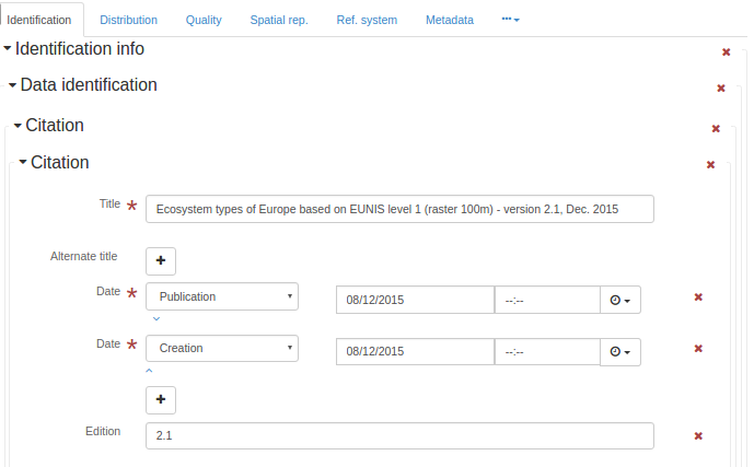
Citation
- Name:
gmd:citation
- Context:
gmd:MD_Identification
- Description:
<gmd:citation xmlns:gmd="http://www.isotc211.org/2005/gmd" xmlns:gml="http://www.opengis.net/gml"
              xmlns:xlink="http://www.w3.org/1999/xlink">
   <gmd:CI_Citation>
      <gmd:title>
         <gco:CharacterString>Ecosystem types of Europe based on EUNIS level 1 (raster 100m) -
              version 2.1, Dec. 2015
            </gco:CharacterString>
      </gmd:title>
      <gmd:date>
         <gmd:CI_Date>
            <gmd:date>
               <gco:Date>2015-12-08</gco:Date>
            </gmd:date>
            <gmd:dateType>
               <gmd:CI_DateTypeCode codeList="http://standards.iso.org/ittf/PubliclyAvailableStandards/ISO_19139_Schemas/resources/codelist/ML_gmxCodelists.xml#CI_DateTypeCode"
                                    codeListValue="publication"/>
            </gmd:dateType>
         </gmd:CI_Date>
      </gmd:date>
      <gmd:date>
         <gmd:CI_Date>
            <gmd:date>
               <gco:Date>2015-12-08</gco:Date>
            </gmd:date>
            <gmd:dateType>
               <gmd:CI_DateTypeCode codeList="http://standards.iso.org/ittf/PubliclyAvailableStandards/ISO_19139_Schemas/resources/codelist/ML_gmxCodelists.xml#CI_DateTypeCode"
                                    codeListValue="creation"/>
            </gmd:dateType>
         </gmd:CI_Date>
      </gmd:date>
      <gmd:edition>
         <gco:CharacterString>2.1</gco:CharacterString>
      </gmd:edition>
      <gmd:identifier>
         <gmd:RS_Identifier>
            <gmd:code>
               <gco:CharacterString>eea_r_3035_100_m_ecosystem-types-l1_2006_rev2-1
                </gco:CharacterString>
            </gmd:code>
         </gmd:RS_Identifier>
      </gmd:identifier>
   </gmd:CI_Citation>
</gmd:citation>
Citation
- Name:
gmd:citation
- Context:
gmd:MD_Thesaurus
- Description:
<gmd:citation xmlns:gmd="http://www.isotc211.org/2005/gmd" xmlns:gml="http://www.opengis.net/gml"
              xmlns:xlink="http://www.w3.org/1999/xlink">
   <gmd:CI_Citation>
      <gmd:title>
         <gco:CharacterString>Ecosystem types of Europe based on EUNIS level 1 (raster 100m) -
              version 2.1, Dec. 2015
            </gco:CharacterString>
      </gmd:title>
      <gmd:date>
         <gmd:CI_Date>
            <gmd:date>
               <gco:Date>2015-12-08</gco:Date>
            </gmd:date>
            <gmd:dateType>
               <gmd:CI_DateTypeCode codeList="http://standards.iso.org/ittf/PubliclyAvailableStandards/ISO_19139_Schemas/resources/codelist/ML_gmxCodelists.xml#CI_DateTypeCode"
                                    codeListValue="publication"/>
            </gmd:dateType>
         </gmd:CI_Date>
      </gmd:date>
      <gmd:date>
         <gmd:CI_Date>
            <gmd:date>
               <gco:Date>2015-12-08</gco:Date>
            </gmd:date>
            <gmd:dateType>
               <gmd:CI_DateTypeCode codeList="http://standards.iso.org/ittf/PubliclyAvailableStandards/ISO_19139_Schemas/resources/codelist/ML_gmxCodelists.xml#CI_DateTypeCode"
                                    codeListValue="creation"/>
            </gmd:dateType>
         </gmd:CI_Date>
      </gmd:date>
      <gmd:edition>
         <gco:CharacterString>2.1</gco:CharacterString>
      </gmd:edition>
      <gmd:identifier>
         <gmd:RS_Identifier>
            <gmd:code>
               <gco:CharacterString>eea_r_3035_100_m_ecosystem-types-l1_2006_rev2-1
                </gco:CharacterString>
            </gmd:code>
         </gmd:RS_Identifier>
      </gmd:identifier>
   </gmd:CI_Citation>
</gmd:citation>
Citation
- Name:
gmd:citation
- Description:
<gmd:citation xmlns:gmd="http://www.isotc211.org/2005/gmd" xmlns:gml="http://www.opengis.net/gml"
              xmlns:xlink="http://www.w3.org/1999/xlink">
   <gmd:CI_Citation>
      <gmd:title>
         <gco:CharacterString>Ecosystem types of Europe based on EUNIS level 1 (raster 100m) -
              version 2.1, Dec. 2015
            </gco:CharacterString>
      </gmd:title>
      <gmd:date>
         <gmd:CI_Date>
            <gmd:date>
               <gco:Date>2015-12-08</gco:Date>
            </gmd:date>
            <gmd:dateType>
               <gmd:CI_DateTypeCode codeList="http://standards.iso.org/ittf/PubliclyAvailableStandards/ISO_19139_Schemas/resources/codelist/ML_gmxCodelists.xml#CI_DateTypeCode"
                                    codeListValue="publication"/>
            </gmd:dateType>
         </gmd:CI_Date>
      </gmd:date>
      <gmd:date>
         <gmd:CI_Date>
            <gmd:date>
               <gco:Date>2015-12-08</gco:Date>
            </gmd:date>
            <gmd:dateType>
               <gmd:CI_DateTypeCode codeList="http://standards.iso.org/ittf/PubliclyAvailableStandards/ISO_19139_Schemas/resources/codelist/ML_gmxCodelists.xml#CI_DateTypeCode"
                                    codeListValue="creation"/>
            </gmd:dateType>
         </gmd:CI_Date>
      </gmd:date>
      <gmd:edition>
         <gco:CharacterString>2.1</gco:CharacterString>
      </gmd:edition>
      <gmd:identifier>
         <gmd:RS_Identifier>
            <gmd:code>
               <gco:CharacterString>eea_r_3035_100_m_ecosystem-types-l1_2006_rev2-1
                </gco:CharacterString>
            </gmd:code>
         </gmd:RS_Identifier>
      </gmd:identifier>
   </gmd:CI_Citation>
</gmd:citation>
Cited responsible party
- Name:
gmd:citedResponsibleParty
- Description:
City
- Name:
gmd:city
- Description:
Classification
- Name:
gmd:classification
- Description:
- Condition:
mandatory
Classification system
- Name:
gmd:classificationSystem
- Description:
Cloud cover percentage
- Name:
gmd:cloudCoverPercentage
- Description:
Unique resource identifier
- Name:
gmd:code
- Context:
gmd:RS_Identifier
- Description:
- Condition:
mandatory
Code
- Name:
gmd:code
- Context:
gmd:MD_Identifier
- Description:
- Condition:
mandatory
Code
- Name:
gmd:code
- Context:
gmd:MD_CodeValue
- Description:
Codespace
- Name:
gmd:codeSpace
- Description:
Recommended values
code |
label |
|---|---|
EPSG |
EPSG |
<gmd:codeSpace xmlns:gmd="http://www.isotc211.org/2005/gmd" xmlns:gml="http://www.opengis.net/gml"
xmlns:xlink="http://www.w3.org/1999/xlink">
<gco:CharacterString>OGP Surveying & Positioning Committee</gco:CharacterString>
</gmd:codeSpace>
Collective title
- Name:
gmd:collectiveTitle
- Description:
Compliance code
- Name:
gmd:complianceCode
- Description:
ComposedOf
- Name:
gmd:composedOf
- Description:
Compression generation quantity
- Name:
gmd:compressionGenerationQuantity
- Description:
Condition
- Name:
gmd:condition
- Description:
Constraint language
- Name:
gmd:constraintLanguage
- Description:
- Condition:
mandatory
Contact
- Name:
gmd:contact
- Context:
gmd:MD_Metadata
- Description:
- Condition:
mandatory
<gmd:contact xmlns:gmd="http://www.isotc211.org/2005/gmd" xmlns:gml="http://www.opengis.net/gml"
             xmlns:xlink="http://www.w3.org/1999/xlink">
   <gmd:CI_ResponsibleParty>
      <gmd:organisationName>
         <gco:CharacterString>European Environment Agency</gco:CharacterString>
      </gmd:organisationName>
      <gmd:contactInfo>
         <gmd:CI_Contact>
            <gmd:address>
               <gmd:CI_Address>
                  <gmd:deliveryPoint>
                     <gco:CharacterString>Kongens Nytorv 6</gco:CharacterString>
                  </gmd:deliveryPoint>
                  <gmd:city>
                     <gco:CharacterString>Copenhagen</gco:CharacterString>
                  </gmd:city>
                  <gmd:administrativeArea>
                     <gco:CharacterString>K</gco:CharacterString>
                  </gmd:administrativeArea>
                  <gmd:postalCode>
                     <gco:CharacterString>1050</gco:CharacterString>
                  </gmd:postalCode>
                  <gmd:country>
                     <gco:CharacterString>Denmark</gco:CharacterString>
                  </gmd:country>
                  <gmd:electronicMailAddress>
                     <gco:CharacterString>eea.enquiries@eea.europa.eu</gco:CharacterString>
                  </gmd:electronicMailAddress>
               </gmd:CI_Address>
            </gmd:address>
         </gmd:CI_Contact>
      </gmd:contactInfo>
      <gmd:role>
         <gmd:CI_RoleCode codeList="http://standards.iso.org/ittf/PubliclyAvailableStandards/ISO_19139_Schemas/resources/codelist/ML_gmxCodelists.xml#CI_RoleCode"
                          codeListValue="pointOfContact"/>
      </gmd:role>
   </gmd:CI_ResponsibleParty>
</gmd:contact>
Contact
- Name:
gmd:contact
- Context:
gmd:MD_MaintenanceInformation
- Description:
<gmd:contact xmlns:gmd="http://www.isotc211.org/2005/gmd" xmlns:gml="http://www.opengis.net/gml"
             xmlns:xlink="http://www.w3.org/1999/xlink">
   <gmd:CI_ResponsibleParty>
      <gmd:organisationName>
         <gco:CharacterString>European Environment Agency</gco:CharacterString>
      </gmd:organisationName>
      <gmd:contactInfo>
         <gmd:CI_Contact>
            <gmd:address>
               <gmd:CI_Address>
                  <gmd:deliveryPoint>
                     <gco:CharacterString>Kongens Nytorv 6</gco:CharacterString>
                  </gmd:deliveryPoint>
                  <gmd:city>
                     <gco:CharacterString>Copenhagen</gco:CharacterString>
                  </gmd:city>
                  <gmd:administrativeArea>
                     <gco:CharacterString>K</gco:CharacterString>
                  </gmd:administrativeArea>
                  <gmd:postalCode>
                     <gco:CharacterString>1050</gco:CharacterString>
                  </gmd:postalCode>
                  <gmd:country>
                     <gco:CharacterString>Denmark</gco:CharacterString>
                  </gmd:country>
                  <gmd:electronicMailAddress>
                     <gco:CharacterString>eea.enquiries@eea.europa.eu</gco:CharacterString>
                  </gmd:electronicMailAddress>
               </gmd:CI_Address>
            </gmd:address>
         </gmd:CI_Contact>
      </gmd:contactInfo>
      <gmd:role>
         <gmd:CI_RoleCode codeList="http://standards.iso.org/ittf/PubliclyAvailableStandards/ISO_19139_Schemas/resources/codelist/ML_gmxCodelists.xml#CI_RoleCode"
                          codeListValue="pointOfContact"/>
      </gmd:role>
   </gmd:CI_ResponsibleParty>
</gmd:contact>
Contact Information
- Name:
gmd:contactInfo
- Description:
Contact instructions
- Name:
gmd:contactInstructions
- Description:
Content Information
- Name:
gmd:contentInfo
- Description:
<gmd:contentInfo xmlns:gmd="http://www.isotc211.org/2005/gmd" xmlns:gml="http://www.opengis.net/gml"
xmlns:xlink="http://www.w3.org/1999/xlink">
<gmd:MD_FeatureCatalogueDescription>
<gmd:includedWithDataset>
<gco:Boolean>false</gco:Boolean>
</gmd:includedWithDataset>
<gmd:featureCatalogueCitation uuidref="e38815ec-a386-45e5-9d1c-b13e0f6ca9e0"
xlink:href="http://sdi.eea.europa.eu/internal-catalogue/srv/eng/csw?service=CSW&request=GetRecordById&version=2.0.2&outputSchema=http://www.isotc211.org/2005/gmd&elementSetName=full&id=e38815ec-a386-45e5-9d1c-b13e0f6ca9e0"/>
</gmd:MD_FeatureCatalogueDescription>
</gmd:contentInfo>
Content type
- Name:
gmd:contentType
- Description:
- Condition:
mandatory
Controlpoint Availability
- Name:
gmd:controlPointAvailability
- Description:
- Condition:
mandatory
Corner points
- Name:
gmd:cornerPoints
- Description:
- Condition:
mandatory
Country
- Name:
gmd:country
- Description:
Country
- Name:
gmd:country
- Context:
gmd:MD_Legislation
- Description:
Country
- Name:
gmd:country
- Context:
PT_Group
- Description:
Credit
- Name:
gmd:credit
- Description:
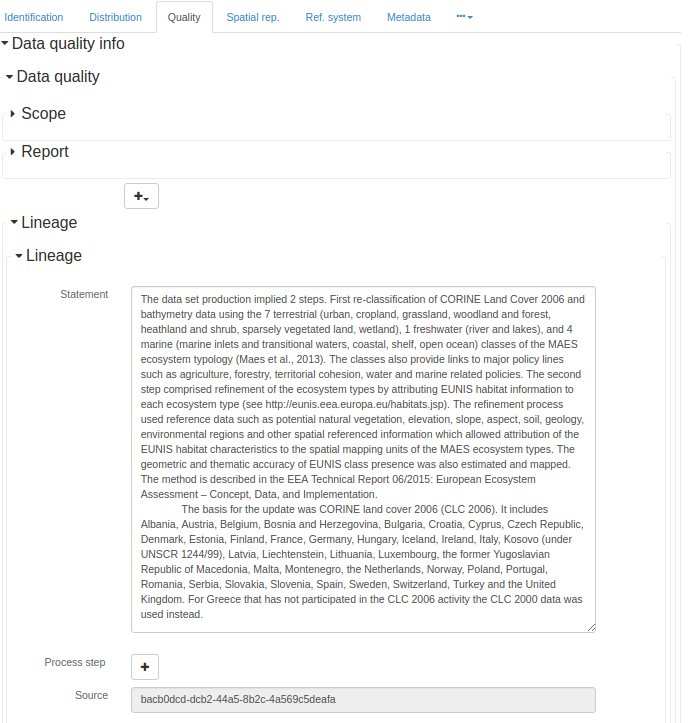
Data quality info
- Name:
gmd:dataQualityInfo
- Description:
<gmd:dataQualityInfo xmlns:gmd="http://www.isotc211.org/2005/gmd" xmlns:gml="http://www.opengis.net/gml"
                     xmlns:xlink="http://www.w3.org/1999/xlink">
   <gmd:DQ_DataQuality>
      <gmd:scope>
         <gmd:DQ_Scope>
            <gmd:level>
               <gmd:MD_ScopeCode codeListValue="dataset"
                                 codeList="http://standards.iso.org/ittf/PubliclyAvailableStandards/ISO_19139_Schemas/resources/codelist/ML_gmxCodelists.xml#MD_ScopeCode"/>
            </gmd:level>
         </gmd:DQ_Scope>
      </gmd:scope>
      <gmd:lineage>
         <gmd:LI_Lineage>
            <gmd:statement>
               <gco:CharacterString>The data set production implied 2 steps. First re-classification of
              CORINE Land Cover 2006 and bathymetry data using the 7 terrestrial (urban, cropland,
              grassland, woodland and forest, heathland and shrub, sparsely vegetated land,
              wetland), 1 freshwater (river and lakes), and 4 marine (marine inlets and transitional
              waters, coastal, shelf, open ocean) classes of the MAES ecosystem typology (Maes et
              al., 2013). The classes also provide links to major policy lines such as agriculture,
              forestry, territorial cohesion, water and marine related policies. The second step
              comprised refinement of the ecosystem types by attributing EUNIS habitat information
              to each ecosystem type (see http://eunis.eea.europa.eu/habitats.jsp). The refinement
              process used reference data such as potential natural vegetation, elevation, slope,
              aspect, soil, geology, environmental regions and other spatial referenced information
              which allowed attribution of the EUNIS habitat characteristics to the spatial mapping
              units of the MAES ecosystem types. The geometric and thematic accuracy of EUNIS class
              presence was also estimated and mapped. The method is described in the EEA Technical
              Report 06/2015: European Ecosystem Assessment – Concept, Data, and Implementation.
              The basis for the update was CORINE land cover 2006 (CLC 2006). It includes Albania,
              Austria, Belgium, Bosnia and Herzegovina, Bulgaria, Croatia, Cyprus, Czech Republic,
              Denmark, Estonia, Finland, France, Germany, Hungary, Iceland, Ireland, Italy, Kosovo
              (under UNSCR 1244/99), Latvia, Liechtenstein, Lithuania, Luxembourg, the former
              Yugoslavian Republic of Macedonia, Malta, Montenegro, the Netherlands, Norway, Poland,
              Portugal, Romania, Serbia, Slovakia, Slovenia, Spain, Sweden, Switzerland, Turkey and
              the United Kingdom. For Greece that has not participated in the CLC 2006 activity the
              CLC 2000 data was used instead.
            </gco:CharacterString>
            </gmd:statement>
            <gmd:source uuidref="bacb0dcd-dcb2-44a5-8b2c-4a569c5deafa"/>
         </gmd:LI_Lineage>
      </gmd:lineage>
   </gmd:DQ_DataQuality>
</gmd:dataQualityInfo>
Dataset
- Name:
gmd:dataset
- Description:
Dataset URI
- Name:
gmd:dataSetURI
- Description:
Data type
- Name:
gmd:dataType
- Description:
- Condition:
mandatory
Date
- Name:
gmd:date
- Description:
- Condition:
mandatory
Date of last update
- Name:
gmd:date
- Context:
gmd:MD_Revision
- Description:
Date of next update
- Name:
gmd:date
- Context:
gmd:MD_MaintenanceInformation
- Description:
Date
- Name:
gmd:date
- Context:
gmd:CI_Citation
- Description:
- Condition:
mandatory
Date
- Name:
gmd:date
- Context:
gmd:CI_Date
- Description:
- Condition:
mandatory
Date of next update
- Name:
gmd:dateOfNextUpdate
- Description:
Date stamp
- Name:
gmd:dateStamp
- Description:
- Condition:
mandatory
<gmd:dateStamp xmlns:gmd="http://www.isotc211.org/2005/gmd" xmlns:gml="http://www.opengis.net/gml"
               xmlns:xlink="http://www.w3.org/1999/xlink">
   <gco:DateTime>2016-01-15T16:57:35</gco:DateTime>
</gmd:dateStamp>
Date / Time
- Name:
gmd:dateTime
- Description:
Date / Time
- Name:
gmd:dateTime
- Context:
LI_ProcessStep
- Description:
Date / Time
- Name:
gmd:dateTime
- Context:
gmd:DQ_Element
- Description:
Date type
- Name:
gmd:dateType
- Description:
- Condition:
mandatory
Definition
- Name:
gmd:definition
- Description:
- Condition:
mandatory
Delivery point
- Name:
gmd:deliveryPoint
- Description:
Denominator
- Name:
gmd:denominator
- Description:
- Condition:
add either a denominator or a distance
Recommended values
code |
label |
|---|---|
5000 |
1:5´000 |
10000 |
1:10´000 |
25000 |
1:25´000 |
50000 |
1:50´000 |
100000 |
1:100´000 |
200000 |
1:200´000 |
300000 |
1:300´000 |
500000 |
1:500´000 |
1000000 |
1:1´000´000 |
Density
- Name:
gmd:density
- Description:
Density units
- Name:
gmd:densityUnits
- Description:
- Condition:
conditional
Describes
- Name:
gmd:describes
- Description:
Description
- Name:
gmd:description
- Description:
Description
- Name:
gmd:description
- Context:
gmd:MD_AbstractClass
- Description:
Description
- Name:
gmd:description
- Context:
LI_ProcessStep
- Description:
- Condition:
mandatory
Description
- Name:
gmd:description
- Context:
LI_Source
- Description:
Description
- Name:
gmd:description
- Context:
gmd:EX_Extent
- Description:
Description
- Name:
gmd:description
- Context:
gmd:CI_OnlineResource
- Description:
Recommended values
code |
label |
|---|---|
ETRS89 / LAEA Europe |
|
Belge 1972 / Belgian Lambert 72 |
|
ETRS89-XYZ: 3D Cartesian in ETRS89 |
|
ETRS89-GRS80h: 3D geodetic in ETRS89 on GRS80 |
|
ETRS89-GRS802D: geodetic in ETRS89 on GRS80 |
|
ETRS89-LAEA2D: LAEA projection in ETRS89 on GRS80 |
|
ETRS89-LCC2D: LCC projection in ETRS89 on GRS80 |
|
ETRS89-TM26N2D: TM projection in ETRS89 on GRS80, zone 26N (30°W to 24°W) |
|
ETRS89-TM27N2D: TM projection in ETRS89 on GRS80, zone 27N (24°W to 18°W) |
|
ETRS89-TM28N: 2D TM projection in ETRS89 on GRS80, zone 28N (18°W to 12°W) |
|
ETRS89-TM29N: 2D TM projection in ETRS89 on GRS80, zone 29N (12°W to 6°W) |
|
ETRS89-TM30N: 2D TM projection in ETRS89 on GRS80, zone 30N (6°W to 0°) |
|
ETRS89-TM31N: 2D TM projection in ETRS89 on GRS80, zone 31N (0° to 6°E) |
|
ETRS89-TM32N: 2D TM projection in ETRS89 on GRS80, zone 32N (6°E to 12°E) |
|
ETRS89-TM33N: 2D TM projection in ETRS89 on GRS80, zone 33N (12°E to 18°E) |
|
ETRS89-TM34N: 2D TM projection in ETRS89 on GRS80, zone 34N (18°E to 24°E) |
|
ETRS89-TM35N: 2D TM projection in ETRS89 on GRS80, zone 35N (24°E to 30°E) |
|
ETRS89-TM36N: 2D TM projection in ETRS89 on GRS80, zone 36N (30°E to 36°E) |
|
ETRS89-TM37N: 2D TM projection in ETRS89 on GRS80, zone 37N (36°E to 42°E) |
|
ETRS89-TM38N: 2D TM projection in ETRS89 on GRS80, zone 38N (42°E to 48°E) |
|
ETRS89-TM39N: 2D TM projection in ETRS89 on GRS80, zone 39N (48°E to 54°E) |
|
EVRS: Height in EVRS |
|
ETRS89-GRS80-EVRS: 3D compound: 2D geodetic in ETRS89 on GRS80, and EVRS height |
|
RGF93 / Lambert-93 |
|
WGS 84 / UTM zone 20N |
|
RGFG95 / UTM zone 22N |
|
RGR92 / UTM zone 40S |
|
RGSPM06 / UTM zone 21N |
|
RGM04 / UTM zone 38S |
Description
- Name:
gmd:description
- Context:
gmd:MD_CodeDomain
- Description:
Value description
- Name:
gmd:description
- Context:
gmd:MD_CodeValue
- Description:
Description
- Name:
gmd:description
- Context:
gmd:MD_Attribute
- Description:
Description
- Name:
gmd:description
- Context:
gmd:MD_Role
- Description:
Descriptive keywords
- Name:
gmd:descriptiveKeywords
- Description:
Descriptor
- Name:
gmd:descriptor
- Description:
Dimension
- Name:
gmd:dimension
- Description:
Dimension name
- Name:
gmd:dimensionName
- Description:
- Condition:
mandatory
Dimension size
- Name:
gmd:dimensionSize
- Description:
- Condition:
mandatory
Distance
- Name:
gmd:distance
- Description:
- Condition:
Provide a distance if no equivalent Scale is documented
Recommended values
code |
label |
|---|---|
0.10 |
10 cm |
0.25 |
25 cm |
0.50 |
50 cm |
1 |
1 m |
30 |
30 m |
100 |
100 m |
<gmd:distance xmlns:gmd="http://www.isotc211.org/2005/gmd" xmlns:gml="http://www.opengis.net/gml"
              xmlns:xlink="http://www.w3.org/1999/xlink">
   <gco:Distance uom="m">100</gco:Distance>
</gmd:distance>
Distribution format
- Name:
gmd:distributionFormat
- Description:
- Condition:
mandatory
<gmd:distributionFormat xmlns:gmd="http://www.isotc211.org/2005/gmd" xmlns:gml="http://www.opengis.net/gml"
                        xmlns:xlink="http://www.w3.org/1999/xlink">
   <gmd:MD_Format>
      <gmd:name>
         <gco:CharacterString>GTiff</gco:CharacterString>
      </gmd:name>
      <gmd:version gco:nilReason="missing">
         <gco:CharacterString/>
      </gmd:version>
   </gmd:MD_Format>
</gmd:distributionFormat>
Distribution Information
- Name:
gmd:distributionInfo
- Description:
<gmd:distributionInfo xmlns:gmd="http://www.isotc211.org/2005/gmd" xmlns:gml="http://www.opengis.net/gml"
                      xmlns:xlink="http://www.w3.org/1999/xlink">
   <gmd:MD_Distribution>
      <gmd:distributionFormat>
         <gmd:MD_Format>
            <gmd:name>
               <gco:CharacterString>GTiff</gco:CharacterString>
            </gmd:name>
            <gmd:version gco:nilReason="missing">
               <gco:CharacterString/>
            </gmd:version>
         </gmd:MD_Format>
      </gmd:distributionFormat>
      <gmd:transferOptions>
         <gmd:MD_DigitalTransferOptions>
            <gmd:onLine>
               <gmd:CI_OnlineResource>
                  <gmd:linkage>
                     <gmd:URL>
                  http://www.eea.europa.eu/data-and-maps/data/ds_resolveuid/d851e1b7f678468b8f0b1b98930ba3e1
                </gmd:URL>
                  </gmd:linkage>
                  <gmd:protocol>
                     <gco:CharacterString>WWW:LINK-1.0-http--link</gco:CharacterString>
                  </gmd:protocol>
                  <gmd:function>
                     <gmd:CI_OnLineFunctionCode codeList="http://standards.iso.org/ittf/PubliclyAvailableStandards/ISO_19139_Schemas/resources/codelist/ML_gmxCodelists.xml#CI_OnLineFunctionCode"
                                                codeListValue="download"/>
                  </gmd:function>
               </gmd:CI_OnlineResource>
            </gmd:onLine>
         </gmd:MD_DigitalTransferOptions>
      </gmd:transferOptions>
   </gmd:MD_Distribution>
</gmd:distributionInfo>
Distribution / Order Process
- Name:
gmd:distributionOrderProcess
- Description:
Distributor
- Name:
gmd:distributor
- Description:
Distributor contact
- Name:
gmd:distributorContact
- Description:
- Condition:
mandatory
Distributor format
- Name:
gmd:distributorFormat
- Description:
- Condition:
conditional
Distributor transfer options
- Name:
gmd:distributorTransferOptions
- Description:
Domain code
- Name:
gmd:domainCode
- Description:
Domain of validity
- Name:
gmd:domainOfValidity
- Description:
Domain value
- Name:
gmd:domainValue
- Description:
Absolute external positional accuracy
- Name:
gmd:DQ_AbsoluteExternalPositionalAccuracy
- Description:
Accuracy of time measurement
- Name:
gmd:DQ_AccuracyOfATimeMeasurement
- Description:
Completeness commission
- Name:
gmd:DQ_CompletenessCommission
- Description:
Completeness omission
- Name:
gmd:DQ_CompletenessOmission
- Description:
Conceptual consistency
- Name:
gmd:DQ_ConceptualConsistency
- Description:
Conformance result
- Name:
gmd:DQ_ConformanceResult
- Description:
Data quality
- Name:
gmd:DQ_DataQuality
- Description:
<gmd:DQ_DataQuality xmlns:gmd="http://www.isotc211.org/2005/gmd" xmlns:gml="http://www.opengis.net/gml"
                    xmlns:xlink="http://www.w3.org/1999/xlink">
   <gmd:scope>
      <gmd:DQ_Scope>
         <gmd:level>
            <gmd:MD_ScopeCode codeListValue="dataset"
                              codeList="http://standards.iso.org/ittf/PubliclyAvailableStandards/ISO_19139_Schemas/resources/codelist/ML_gmxCodelists.xml#MD_ScopeCode"/>
         </gmd:level>
      </gmd:DQ_Scope>
   </gmd:scope>
   <gmd:lineage>
      <gmd:LI_Lineage>
         <gmd:statement>
            <gco:CharacterString>The data set production implied 2 steps. First re-classification of
              CORINE Land Cover 2006 and bathymetry data using the 7 terrestrial (urban, cropland,
              grassland, woodland and forest, heathland and shrub, sparsely vegetated land,
              wetland), 1 freshwater (river and lakes), and 4 marine (marine inlets and transitional
              waters, coastal, shelf, open ocean) classes of the MAES ecosystem typology (Maes et
              al., 2013). The classes also provide links to major policy lines such as agriculture,
              forestry, territorial cohesion, water and marine related policies. The second step
              comprised refinement of the ecosystem types by attributing EUNIS habitat information
              to each ecosystem type (see http://eunis.eea.europa.eu/habitats.jsp). The refinement
              process used reference data such as potential natural vegetation, elevation, slope,
              aspect, soil, geology, environmental regions and other spatial referenced information
              which allowed attribution of the EUNIS habitat characteristics to the spatial mapping
              units of the MAES ecosystem types. The geometric and thematic accuracy of EUNIS class
              presence was also estimated and mapped. The method is described in the EEA Technical
              Report 06/2015: European Ecosystem Assessment – Concept, Data, and Implementation.
              The basis for the update was CORINE land cover 2006 (CLC 2006). It includes Albania,
              Austria, Belgium, Bosnia and Herzegovina, Bulgaria, Croatia, Cyprus, Czech Republic,
              Denmark, Estonia, Finland, France, Germany, Hungary, Iceland, Ireland, Italy, Kosovo
              (under UNSCR 1244/99), Latvia, Liechtenstein, Lithuania, Luxembourg, the former
              Yugoslavian Republic of Macedonia, Malta, Montenegro, the Netherlands, Norway, Poland,
              Portugal, Romania, Serbia, Slovakia, Slovenia, Spain, Sweden, Switzerland, Turkey and
              the United Kingdom. For Greece that has not participated in the CLC 2006 activity the
              CLC 2000 data was used instead.
            </gco:CharacterString>
         </gmd:statement>
         <gmd:source uuidref="bacb0dcd-dcb2-44a5-8b2c-4a569c5deafa"/>
      </gmd:LI_Lineage>
   </gmd:lineage>
</gmd:DQ_DataQuality>
Domain consistency
- Name:
gmd:DQ_DomainConsistency
- Description:
Evaluation method type code
- Name:
gmd:DQ_EvaluationMethodTypeCode
- Description:
Standard codelists Evaluation method type code (gmd:DQ_EvaluationMethodTypeCode)
code |
label |
description |
|---|---|---|
directInternal |
Direct internal |
Method of evaluating the quality of a dataset based on inspection of items within the dataset, where all data required is internal to the dataset being evaluated |
directExternal |
Direct external |
Method of evaluating the quality of a dataset based on inspection of items within the dataset, where reference data external to the dataset being evaluated is required |
indirect |
Indirect |
Method of evaluating the quality of a dataset based on external knowledge |
Format consistency
- Name:
gmd:DQ_FormatConsistency
- Description:
Gridded data positional accuracy
- Name:
gmd:DQ_GriddedDataPositionalAccuracy
- Description:
Non quantitative attribute accuracy
- Name:
gmd:DQ_NonQuantitativeAttributeAccuracy
- Description:
Quantitative attribute accuracy
- Name:
gmd:DQ_QuantitativeAttributeAccuracy
- Description:
Quantitative result
- Name:
gmd:DQ_QuantitativeResult
- Description:
Relative internal positional accuracy
- Name:
gmd:DQ_RelativeInternalPositionalAccuracy
- Description:
Scope
- Name:
gmd:DQ_Scope
- Description:
<gmd:DQ_Scope xmlns:gmd="http://www.isotc211.org/2005/gmd" xmlns:gml="http://www.opengis.net/gml"
              xmlns:xlink="http://www.w3.org/1999/xlink">
   <gmd:level>
      <gmd:MD_ScopeCode codeListValue="dataset"
                        codeList="http://standards.iso.org/ittf/PubliclyAvailableStandards/ISO_19139_Schemas/resources/codelist/ML_gmxCodelists.xml#MD_ScopeCode"/>
   </gmd:level>
</gmd:DQ_Scope>
Temporal consistency
- Name:
gmd:DQ_TemporalConsistency
- Description:
Temporal validity
- Name:
gmd:DQ_TemporalValidity
- Description:
Thematic classification correctness
- Name:
gmd:DQ_ThematicClassificationCorrectness
- Description:
Topological consistency
- Name:
gmd:DQ_TopologicalConsistency
- Description:
DS_Association
- Name:
gmd:DS_Association
- Description:
Association Type
- Name:
gmd:DS_AssociationTypeCode
- Description:
Standard codelists Association Type (gmd:DS_AssociationTypeCode)
code |
label |
description |
|---|---|---|
crossReference |
Cross reference |
Reference from one dataset to another |
largerWorkCitation |
Larger work citation |
Reference to a master dataset of which this one is a part |
partOfSeamlessDatabase |
Part of seamless database |
Part of the same structured set of data held in a computer |
source |
Source |
Mapping and charting information from which the dataset content originates |
stereoMate |
Stereo mate |
Part of a set of imagery that when used together, provides three-dimensional images |
DS_DataSet
- Name:
gmd:DS_DataSet
- Description:
DS_Initiative
- Name:
gmd:DS_Initiative
- Description:
Initiative Type
- Name:
gmd:DS_InitiativeTypeCode
- Description:
Standard codelists Initiative Type (gmd:DS_InitiativeTypeCode)
code |
label |
description |
|---|---|---|
campaign |
Campaign |
Series of organized planned actions |
collection |
Collection |
Accumulation of datasets assembled for a specific purpose |
exercise |
Exercise |
Specific performance of a function or group of functions |
experiment |
Experiment |
Process designed to find if something is effective or valid |
investigation |
Investigation |
Search or systematic inquiry |
mission |
Mission |
Specific operation of a data collection system |
sensor |
Sensor |
Device or piece of equipment which detects or records |
operation |
Operation |
Action that is part of a series of actions |
platform |
Platform |
Vehicle or other support base that holds a sensor |
process |
Process |
Method of doing something involving a number of steps |
program |
Program |
Specific planned activity |
project |
Project |
Organized undertaking, research, or development |
study |
Study |
Examination or investigation |
task |
Task |
Piece of work |
trial |
Trial |
Process of testing to discover or demonstrate something |
DS_OtherAggregate
- Name:
gmd:DS_OtherAggregate
- Description:
DS_Platform
- Name:
gmd:DS_Platform
- Description:
DS_ProductionSeries
- Name:
gmd:DS_ProductionSeries
- Description:
DS_Sensor
- Name:
gmd:DS_Sensor
- Description:
DS_Series
- Name:
gmd:DS_Series
- Description:
DS_StereoMate
- Name:
gmd:DS_StereoMate
- Description:
East bound
- Name:
gmd:eastBoundLongitude
- Description:
- Condition:
mandatory
<gmd:eastBoundLongitude xmlns:gmd="http://www.isotc211.org/2005/gmd" xmlns:gml="http://www.opengis.net/gml"
                        xmlns:xlink="http://www.w3.org/1999/xlink">
   <gco:Decimal>38.1471</gco:Decimal>
</gmd:eastBoundLongitude>
Edition
- Name:
gmd:edition
- Description:
<gmd:edition xmlns:gmd="http://www.isotc211.org/2005/gmd" xmlns:gml="http://www.opengis.net/gml"
             xmlns:xlink="http://www.w3.org/1999/xlink">
   <gco:CharacterString>2.1</gco:CharacterString>
</gmd:edition>
Edition date
- Name:
gmd:editionDate
- Description:
Electronic mail address
- Name:
gmd:electronicMailAddress
- Description:
Environment description
- Name:
gmd:environmentDescription
- Description:
Equivalent scale
- Name:
gmd:equivalentScale
- Description:
Error statistic
- Name:
gmd:errorStatistic
- Description:
Evaluation method description
- Name:
gmd:evaluationMethodDescription
- Description:
Evaluation Method
- Name:
gmd:evaluationMethodType
- Description:
Evaluation procedure
- Name:
gmd:evaluationProcedure
- Description:
Bounding Polygon
- Name:
gmd:EX_BoundingPolygon
- Description:
Extent
- Name:
gmd:EX_Extent
- Description:
Geographic bounding box
- Name:
gmd:EX_GeographicBoundingBox
- Description:
<gmd:EX_GeographicBoundingBox xmlns:gmd="http://www.isotc211.org/2005/gmd" xmlns:gml="http://www.opengis.net/gml"
                              xmlns:xlink="http://www.w3.org/1999/xlink">
   <gmd:westBoundLongitude>
      <gco:Decimal>-33.90432</gco:Decimal>
   </gmd:westBoundLongitude>
   <gmd:eastBoundLongitude>
      <gco:Decimal>38.1471</gco:Decimal>
   </gmd:eastBoundLongitude>
   <gmd:southBoundLatitude>
      <gco:Decimal>26.988714</gco:Decimal>
   </gmd:southBoundLatitude>
   <gmd:northBoundLatitude>
      <gco:Decimal>60.57849</gco:Decimal>
   </gmd:northBoundLatitude>
</gmd:EX_GeographicBoundingBox>
Geographic description
- Name:
gmd:EX_GeographicDescription
- Description:
Spatial Temporal Extent
- Name:
gmd:EX_SpatialTemporalExtent
- Description:
Temporal Extent
- Name:
gmd:EX_TemporalExtent
- Description:
<gmd:EX_TemporalExtent xmlns:gmd="http://www.isotc211.org/2005/gmd" xmlns:gml="http://www.opengis.net/gml"
                       xmlns:xlink="http://www.w3.org/1999/xlink">
   <gmd:extent>
      <gml:TimePeriod gml:id="d28e322a1049886">
         <gml:beginPosition>2006-01-01</gml:beginPosition>
         <gml:endPosition>2006-12-31</gml:endPosition>
      </gml:TimePeriod>
   </gmd:extent>
</gmd:EX_TemporalExtent>
Vertical extent
- Name:
gmd:EX_VerticalExtent
- Description:
Explanation
- Name:
gmd:explanation
- Description:
- Condition:
mandatory
Extended element information
- Name:
gmd:extendedElementInformation
- Description:
Extension Online resource
- Name:
gmd:extensionOnLineResource
- Description:
Extent
- Name:
gmd:extent
- Context:
gmd:MD_DataIdentification
- Description:
Extent
- Name:
gmd:extent
- Context:
gmd:DQ_Scope
- Description:
Extent
- Name:
gmd:extent
- Context:
gmd:EX_TemporalExtent
- Description:
Extent type code
- Name:
gmd:extentTypeCode
- Description:
Facsimile
- Name:
gmd:facsimile
- Description:
Feature attribute
- Name:
gmd:featureAttribute
- Description:
Feature catalogue citation
- Name:
gmd:featureCatalogueCitation
- Description:
- Condition:
mandatory
<gmd:featureCatalogueCitation xmlns:gmd="http://www.isotc211.org/2005/gmd" xmlns:gml="http://www.opengis.net/gml"
uuidref="e38815ec-a386-45e5-9d1c-b13e0f6ca9e0"
xlink:href="http://sdi.eea.europa.eu/internal-catalogue/srv/eng/csw?service=CSW&request=GetRecordById&version=2.0.2&outputSchema=http://www.isotc211.org/2005/gmd&elementSetName=full&id=e38815ec-a386-45e5-9d1c-b13e0f6ca9e0"/>
Feature instances
- Name:
gmd:featureInstances
- Description:
Features
- Name:
gmd:features
- Description:
Feature type
- Name:
gmd:featureType
- Description:
Feature types
- Name:
gmd:featureTypes
- Description:
Fees
- Name:
gmd:fees
- Description:
File decompression technique
- Name:
gmd:fileDecompressionTechnique
- Description:
File description
- Name:
gmd:fileDescription
- Description:
File identifier
- Name:
gmd:fileIdentifier
- Description:
<gmd:fileIdentifier xmlns:gmd="http://www.isotc211.org/2005/gmd" xmlns:gml="http://www.opengis.net/gml"
                    xmlns:xlink="http://www.w3.org/1999/xlink">
   <gco:CharacterString>e8a366b7-0029-44d7-ae33-7578253179c0</gco:CharacterString>
</gmd:fileIdentifier>
File name
- Name:
gmd:fileName
- Description:
- Condition:
mandatory
<gmd:fileName xmlns:gmd="http://www.isotc211.org/2005/gmd" xmlns:gml="http://www.opengis.net/gml"
              xmlns:xlink="http://www.w3.org/1999/xlink">
   <gco:CharacterString>
              http://sdi.eea.europa.eu/public/catalogue-graphic-overview/e8a366b7-0029-44d7-ae33-7578253179c0.png
            </gco:CharacterString>
</gmd:fileName>
File type
- Name:
gmd:fileType
- Description:
Film distortion information availability
- Name:
gmd:filmDistortionInformationAvailability
- Description:
Format distributor
- Name:
gmd:formatDistributor
- Description:
Function
- Name:
gmd:function
- Description:
Geographic element
- Name:
gmd:geographicElement
- Description:
<gmd:geographicElement xmlns:gmd="http://www.isotc211.org/2005/gmd" xmlns:gml="http://www.opengis.net/gml"
                       xmlns:xlink="http://www.w3.org/1999/xlink">
   <gmd:EX_GeographicBoundingBox>
      <gmd:westBoundLongitude>
         <gco:Decimal>-33.90432</gco:Decimal>
      </gmd:westBoundLongitude>
      <gmd:eastBoundLongitude>
         <gco:Decimal>38.1471</gco:Decimal>
      </gmd:eastBoundLongitude>
      <gmd:southBoundLatitude>
         <gco:Decimal>26.988714</gco:Decimal>
      </gmd:southBoundLatitude>
      <gmd:northBoundLatitude>
         <gco:Decimal>60.57849</gco:Decimal>
      </gmd:northBoundLatitude>
   </gmd:EX_GeographicBoundingBox>
</gmd:geographicElement>
Geographic identifier
- Name:
gmd:geographicIdentifier
- Description:
- Condition:
mandatory
Geometric object count
- Name:
gmd:geometricObjectCount
- Description:
Geometric objects
- Name:
gmd:geometricObjects
- Description:
Geometric object type
- Name:
gmd:geometricObjectType
- Description:
- Condition:
mandatory
GeoreferencedParameters
- Name:
gmd:georeferencedParameters
- Description:
Graphic overview
- Name:
gmd:graphicOverview
- Description:
<gmd:graphicOverview xmlns:gmd="http://www.isotc211.org/2005/gmd" xmlns:gml="http://www.opengis.net/gml"
                     xmlns:xlink="http://www.w3.org/1999/xlink">
   <gmd:MD_BrowseGraphic>
      <gmd:fileName>
         <gco:CharacterString>
              http://sdi.eea.europa.eu/public/catalogue-graphic-overview/e8a366b7-0029-44d7-ae33-7578253179c0.png
            </gco:CharacterString>
      </gmd:fileName>
   </gmd:MD_BrowseGraphic>
</gmd:graphicOverview>
Graphics file
- Name:
gmd:graphicsFile
- Description:
Handling description
- Name:
gmd:handlingDescription
- Description:
Has
- Name:
gmd:has
- Description:
Hierarchy level
- Name:
gmd:hierarchyLevel
- Description:
<gmd:hierarchyLevel xmlns:gmd="http://www.isotc211.org/2005/gmd" xmlns:gml="http://www.opengis.net/gml"
                    xmlns:xlink="http://www.w3.org/1999/xlink">
   <gmd:MD_ScopeCode codeList="http://standards.iso.org/ittf/PubliclyAvailableStandards/ISO_19139_Schemas/resources/codelist/ML_gmxCodelists.xml#MD_ScopeCode"
                     codeListValue="dataset"/>
</gmd:hierarchyLevel>
Hierarchy level name
- Name:
gmd:hierarchyLevelName
- Description:
Hours of service
- Name:
gmd:hoursOfService
- Description:
Identification info
- Name:
gmd:identificationInfo
- Description:
- Condition:
mandatory
<gmd:identificationInfo xmlns:gmd="http://www.isotc211.org/2005/gmd" xmlns:gml="http://www.opengis.net/gml"
xmlns:xlink="http://www.w3.org/1999/xlink">
<gmd:MD_DataIdentification>
<gmd:citation>
<gmd:CI_Citation>
<gmd:title>
<gco:CharacterString>Ecosystem types of Europe based on EUNIS level 1 (raster 100m) -
version 2.1, Dec. 2015
</gco:CharacterString>
</gmd:title>
<gmd:date>
<gmd:CI_Date>
<gmd:date>
<gco:Date>2015-12-08</gco:Date>
</gmd:date>
<gmd:dateType>
<gmd:CI_DateTypeCode codeList="http://standards.iso.org/ittf/PubliclyAvailableStandards/ISO_19139_Schemas/resources/codelist/ML_gmxCodelists.xml#CI_DateTypeCode"
codeListValue="publication"/>
</gmd:dateType>
</gmd:CI_Date>
</gmd:date>
<gmd:date>
<gmd:CI_Date>
<gmd:date>
<gco:Date>2015-12-08</gco:Date>
</gmd:date>
<gmd:dateType>
<gmd:CI_DateTypeCode codeList="http://standards.iso.org/ittf/PubliclyAvailableStandards/ISO_19139_Schemas/resources/codelist/ML_gmxCodelists.xml#CI_DateTypeCode"
codeListValue="creation"/>
</gmd:dateType>
</gmd:CI_Date>
</gmd:date>
<gmd:edition>
<gco:CharacterString>2.1</gco:CharacterString>
</gmd:edition>
<gmd:identifier>
<gmd:RS_Identifier>
<gmd:code>
<gco:CharacterString>eea_r_3035_100_m_ecosystem-types-l1_2006_rev2-1
</gco:CharacterString>
</gmd:code>
</gmd:RS_Identifier>
</gmd:identifier>
</gmd:CI_Citation>
</gmd:citation>
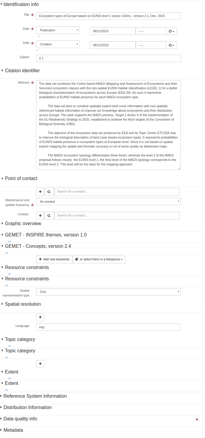
<gmd:abstract>
<gco:CharacterString>The data set combines the Corine based MAES (Mapping and Assessment of
Ecosystems and their Services) ecosystem classes with the non-spatial EUNIS habitat
classification (LEVEL 1) for a better biological characterization of ecosystems across
Europe (EEA-39). As such it represents probabilities of EUNIS habitat presence for each
MAES ecosystem type.
The data set aims to combine spatially explicit land cover information with non-spatially
referenced habitat information to improve our knowledge about ecosystems and their
distribution across Europe. The work supports the MAES process, Target 2 Action 5 of the
implementation of the EU Biodiversity Strategy to 2020, established to achieve the Aichi
targets of the Convention of Biological Diversity (CBD).
The objective of the ecosystem data set produced by EEA and its Topic Centre ETC/SIA was
to improve the biological description of land cover based ecosystem types. It represents
probabilities of EUNIS habitat presence in ecosystem types at European level. Since it is
not based on spatial explicit mapping the spatial and thematic accuracy is not of same
quality as delineated maps.
The MAES ecosystem typology differentiates three levels: whereas the level 2 of the MAES
proposal follows closely the EUNIS level 1, the third level of the MAES typology
corresponds to the EUNIS level 2. This level will be the base for the mapping approach.
</gco:CharacterString>
</gmd:abstract>
<gmd:pointOfContact>
<gmd:CI_ResponsibleParty>
<gmd:organisationName>
<gco:CharacterString>European Environment Agency</gco:CharacterString>
</gmd:organisationName>
<gmd:contactInfo>
<gmd:CI_Contact>
<gmd:address>
<gmd:CI_Address>
<gmd:deliveryPoint>
<gco:CharacterString>Kongens Nytorv 6</gco:CharacterString>
</gmd:deliveryPoint>
<gmd:city>
<gco:CharacterString>Copenhagen</gco:CharacterString>
</gmd:city>
<gmd:administrativeArea>
<gco:CharacterString>K</gco:CharacterString>
</gmd:administrativeArea>
<gmd:postalCode>
<gco:CharacterString>1050</gco:CharacterString>
</gmd:postalCode>
<gmd:country>
<gco:CharacterString>Denmark</gco:CharacterString>
</gmd:country>
<gmd:electronicMailAddress>
<gco:CharacterString>eea.enquiries@eea.europa.eu</gco:CharacterString>
</gmd:electronicMailAddress>
</gmd:CI_Address>
</gmd:address>
<gmd:onlineResource>
<gmd:CI_OnlineResource>
<gmd:linkage>
<gmd:URL>http://www.eea.europa.eu</gmd:URL>
</gmd:linkage>
<gmd:protocol>
<gco:CharacterString>WWW:LINK-1.0-http--link</gco:CharacterString>
</gmd:protocol>
<gmd:name>
<gco:CharacterString>Europen Environment Agency public website
</gco:CharacterString>
</gmd:name>
<gmd:function>
<gmd:CI_OnLineFunctionCode codeList="http://standards.iso.org/ittf/PubliclyAvailableStandards/ISO_19139_Schemas/resources/codelist/ML_gmxCodelists.xml#CI_OnLineFunctionCode"
codeListValue="information"/>
</gmd:function>
</gmd:CI_OnlineResource>
</gmd:onlineResource>
</gmd:CI_Contact>
</gmd:contactInfo>
<gmd:role>
<gmd:CI_RoleCode codeList="http://standards.iso.org/ittf/PubliclyAvailableStandards/ISO_19139_Schemas/resources/codelist/ML_gmxCodelists.xml#CI_RoleCode"
codeListValue="pointOfContact"/>
</gmd:role>
</gmd:CI_ResponsibleParty>
</gmd:pointOfContact>
<gmd:resourceMaintenance>
<gmd:MD_MaintenanceInformation>
<gmd:maintenanceAndUpdateFrequency>
<gmd:MD_MaintenanceFrequencyCode codeList="http://standards.iso.org/ittf/PubliclyAvailableStandards/ISO_19139_Schemas/resources/codelist/ML_gmxCodelists.xml#MD_MaintenanceFrequencyCode"
codeListValue="asNeeded"/>
</gmd:maintenanceAndUpdateFrequency>
</gmd:MD_MaintenanceInformation>
</gmd:resourceMaintenance>
<gmd:graphicOverview>
<gmd:MD_BrowseGraphic>
<gmd:fileName>
<gco:CharacterString>
http://sdi.eea.europa.eu/public/catalogue-graphic-overview/e8a366b7-0029-44d7-ae33-7578253179c0.png
</gco:CharacterString>
</gmd:fileName>
</gmd:MD_BrowseGraphic>
</gmd:graphicOverview>
<gmd:descriptiveKeywords>
<gmd:MD_Keywords>
<gmd:keyword>
<gco:CharacterString>Land cover</gco:CharacterString>
</gmd:keyword>
<gmd:keyword>
<gco:CharacterString>Habitats and biotopes</gco:CharacterString>
</gmd:keyword>
<gmd:type>
<gmd:MD_KeywordTypeCode codeList="http://www.isotc211.org/2005/resources/codeList.xml#MD_KeywordTypeCode"
codeListValue="theme"/>
</gmd:type>
<gmd:thesaurusName>
<gmd:CI_Citation>
<gmd:title>
<gco:CharacterString>GEMET - INSPIRE themes, version 1.0</gco:CharacterString>
</gmd:title>
<gmd:date>
<gmd:CI_Date>
<gmd:date>
<gco:Date>2008-06-01</gco:Date>
</gmd:date>
<gmd:dateType>
<gmd:CI_DateTypeCode codeList="http://standards.iso.org/ittf/PubliclyAvailableStandards/ISO_19139_Schemas/resources/codelist/ML_gmxCodelists.xml#CI_DateTypeCode"
codeListValue="publication"/>
</gmd:dateType>
</gmd:CI_Date>
</gmd:date>
<gmd:identifier>
<gmd:MD_Identifier>
<gmd:code>
<gmx:Anchor xmlns:gmx="http://www.isotc211.org/2005/gmx"
xlink:href="http://sdi.eea.europa.eu/internal-catalogue/srv/eng/thesaurus.download?ref=external.theme.httpinspireeceuropaeutheme-theme">
geonetwork.thesaurus.external.theme.httpinspireeceuropaeutheme-theme
</gmx:Anchor>
</gmd:code>
</gmd:MD_Identifier>
</gmd:identifier>
</gmd:CI_Citation>
</gmd:thesaurusName>
</gmd:MD_Keywords>
</gmd:descriptiveKeywords>
<gmd:descriptiveKeywords>
<gmd:MD_Keywords>
<gmd:keyword>
<gco:CharacterString>ecosystem</gco:CharacterString>
</gmd:keyword>
<gmd:keyword>
<gco:CharacterString>ecosystem type</gco:CharacterString>
</gmd:keyword>
<gmd:keyword>
<gco:CharacterString>land cover</gco:CharacterString>
</gmd:keyword>
<gmd:keyword>
<gco:CharacterString>environmental assessment</gco:CharacterString>
</gmd:keyword>
<gmd:keyword>
<gco:CharacterString>habitat</gco:CharacterString>
</gmd:keyword>
<gmd:type>
<gmd:MD_KeywordTypeCode codeList="http://www.isotc211.org/2005/resources/codeList.xml#MD_KeywordTypeCode"
codeListValue="theme"/>
</gmd:type>
<gmd:thesaurusName>
<gmd:CI_Citation>
<gmd:title>
<gco:CharacterString>GEMET - Concepts, version 2.4</gco:CharacterString>
</gmd:title>
<gmd:date>
<gmd:CI_Date>
<gmd:date>
<gco:Date>2010-01-13</gco:Date>
</gmd:date>
<gmd:dateType>
<gmd:CI_DateTypeCode codeList="http://standards.iso.org/ittf/PubliclyAvailableStandards/ISO_19139_Schemas/resources/codelist/ML_gmxCodelists.xml#CI_DateTypeCode"
codeListValue="publication"/>
</gmd:dateType>
</gmd:CI_Date>
</gmd:date>
<gmd:identifier>
<gmd:MD_Identifier>
<gmd:code>
<gmx:Anchor xmlns:gmx="http://www.isotc211.org/2005/gmx"
xlink:href="http://sdi.eea.europa.eu/internal-catalogue/srv/eng/thesaurus.download?ref=external.theme.gemet">
geonetwork.thesaurus.external.theme.gemet
</gmx:Anchor>
</gmd:code>
</gmd:MD_Identifier>
</gmd:identifier>
</gmd:CI_Citation>
</gmd:thesaurusName>
</gmd:MD_Keywords>
</gmd:descriptiveKeywords>
<gmd:resourceConstraints>
<gmd:MD_Constraints>
<gmd:useLimitation>
<gco:CharacterString>Unless otherwise indicated, re-use of content on the EEA website
for commercial or non-commercial purposes is permitted free of charge, provided that
the source is acknowledged. The EEA re-use policy follows Directive 2003/98/EC of the
European Parliament and the Council on the re-use of public sector information
throughout the European Union and Commission Decision 2006/291/EC, Euratom on the
re-use of Commission information. The EEA accepts no responsibility or liability
whatsoever for the re-use of content accessible on its website. Any inquiries about
re-use of content on the EEA website should be addressed to Ove Caspersen, EEA,
Kongens Nytorv 6, DK-1050 Copenhagen K, Tel +45 33 36 71 00, Fax +45 33 36 71 99,
e-mail copyrights at eea.europa.eu
</gco:CharacterString>
</gmd:useLimitation>
</gmd:MD_Constraints>
</gmd:resourceConstraints>
<gmd:resourceConstraints>
<gmd:MD_LegalConstraints>
<gmd:accessConstraints>
<gmd:MD_RestrictionCode codeList="http://standards.iso.org/ittf/PubliclyAvailableStandards/ISO_19139_Schemas/resources/codelist/ML_gmxCodelists.xml#MD_RestrictionCode"
codeListValue="otherRestrictions"/>
</gmd:accessConstraints>
<gmd:otherConstraints>
<gco:CharacterString>no limitations</gco:CharacterString>
</gmd:otherConstraints>
</gmd:MD_LegalConstraints>
</gmd:resourceConstraints>
<gmd:spatialRepresentationType>
<gmd:MD_SpatialRepresentationTypeCode codeList="http://standards.iso.org/ittf/PubliclyAvailableStandards/ISO_19139_Schemas/resources/codelist/ML_gmxCodelists.xml#MD_SpatialRepresentationTypeCode"
codeListValue="grid"/>
</gmd:spatialRepresentationType>
<gmd:spatialResolution>
<gmd:MD_Resolution>
<gmd:distance>
<gco:Distance uom="m">100</gco:Distance>
</gmd:distance>
</gmd:MD_Resolution>
</gmd:spatialResolution>
<gmd:language>
<gmd:LanguageCode codeList="http://www.loc.gov/standards/iso639-2/" codeListValue="eng"/>
</gmd:language>
<gmd:topicCategory>
<gmd:MD_TopicCategoryCode>biota</gmd:MD_TopicCategoryCode>
</gmd:topicCategory>
<gmd:topicCategory>
<gmd:MD_TopicCategoryCode>environment</gmd:MD_TopicCategoryCode>
</gmd:topicCategory>
<gmd:extent>
<gmd:EX_Extent>
<gmd:geographicElement>
<gmd:EX_GeographicBoundingBox>
<gmd:westBoundLongitude>
<gco:Decimal>-33.90432</gco:Decimal>
</gmd:westBoundLongitude>
<gmd:eastBoundLongitude>
<gco:Decimal>38.1471</gco:Decimal>
</gmd:eastBoundLongitude>
<gmd:southBoundLatitude>
<gco:Decimal>26.988714</gco:Decimal>
</gmd:southBoundLatitude>
<gmd:northBoundLatitude>
<gco:Decimal>60.57849</gco:Decimal>
</gmd:northBoundLatitude>
</gmd:EX_GeographicBoundingBox>
</gmd:geographicElement>
</gmd:EX_Extent>
</gmd:extent>
<gmd:extent>
<gmd:EX_Extent>
<gmd:temporalElement>
<gmd:EX_TemporalExtent>
<gmd:extent>
<gml:TimePeriod gml:id="d28e322a1049886">
<gml:beginPosition>2006-01-01</gml:beginPosition>
<gml:endPosition>2006-12-31</gml:endPosition>
</gml:TimePeriod>
</gmd:extent>
</gmd:EX_TemporalExtent>
</gmd:temporalElement>
</gmd:EX_Extent>
</gmd:extent>
</gmd:MD_DataIdentification>
</gmd:identificationInfo>
Identifier
- Name:
gmd:identifier
- Description:
Citation identifier
- Name:
gmd:identifier
- Context:
gmd:CI_Citation
- Description:
Illumination azimuth angle
- Name:
gmd:illuminationAzimuthAngle
- Description:
Illumination elevation angle
- Name:
gmd:illuminationElevationAngle
- Description:
Image quality code
- Name:
gmd:imageQualityCode
- Description:
Imaging condition
- Name:
gmd:imagingCondition
- Description:
Included with dataset
- Name:
gmd:includedWithDataset
- Description:
- Condition:
mandatory
<gmd:includedWithDataset xmlns:gmd="http://www.isotc211.org/2005/gmd" xmlns:gml="http://www.opengis.net/gml"
                         xmlns:xlink="http://www.w3.org/1999/xlink">
   <gco:Boolean>false</gco:Boolean>
</gmd:includedWithDataset>
Individual name
- Name:
gmd:individualName
- Description:
Initiative Type
- Name:
gmd:initiativeType
- Description:
ISBN
- Name:
gmd:ISBN
- Description:
ISSN
- Name:
gmd:ISSN
- Description:
Issue identification
- Name:
gmd:issueIdentification
- Description:
Keyword
- Name:
gmd:keyword
- Description:
Metadata language
- Name:
gmd:language
- Description:
- Condition:
conditional
Language
- Name:
gmd:language
- Context:
gmd:MD_DataIdentification
- Description:
Language
- Name:
gmd:language
- Context:
gmd:MD_FeatureCatalogueDescription
- Description:
Language
- Name:
gmd:languageCode
- Description:
ISO Language code
- Name:
gmd:LanguageCode
- Description:
Lens distortion information availability
- Name:
gmd:lensDistortionInformationAvailability
- Description:
Hierarchy level
- Name:
gmd:level
- Description:
- Condition:
mandatory
<gmd:level xmlns:gmd="http://www.isotc211.org/2005/gmd" xmlns:gml="http://www.opengis.net/gml"
           xmlns:xlink="http://www.w3.org/1999/xlink">
   <gmd:MD_ScopeCode codeListValue="dataset"
                     codeList="http://standards.iso.org/ittf/PubliclyAvailableStandards/ISO_19139_Schemas/resources/codelist/ML_gmxCodelists.xml#MD_ScopeCode"/>
</gmd:level>
Level description
- Name:
gmd:levelDescription
- Description:
Lineage
- Name:
gmd:LI_Lineage
- Description:
<gmd:LI_Lineage xmlns:gmd="http://www.isotc211.org/2005/gmd" xmlns:gml="http://www.opengis.net/gml"
                xmlns:xlink="http://www.w3.org/1999/xlink">
   <gmd:statement>
      <gco:CharacterString>The data set production implied 2 steps. First re-classification of
              CORINE Land Cover 2006 and bathymetry data using the 7 terrestrial (urban, cropland,
              grassland, woodland and forest, heathland and shrub, sparsely vegetated land,
              wetland), 1 freshwater (river and lakes), and 4 marine (marine inlets and transitional
              waters, coastal, shelf, open ocean) classes of the MAES ecosystem typology (Maes et
              al., 2013). The classes also provide links to major policy lines such as agriculture,
              forestry, territorial cohesion, water and marine related policies. The second step
              comprised refinement of the ecosystem types by attributing EUNIS habitat information
              to each ecosystem type (see http://eunis.eea.europa.eu/habitats.jsp). The refinement
              process used reference data such as potential natural vegetation, elevation, slope,
              aspect, soil, geology, environmental regions and other spatial referenced information
              which allowed attribution of the EUNIS habitat characteristics to the spatial mapping
              units of the MAES ecosystem types. The geometric and thematic accuracy of EUNIS class
              presence was also estimated and mapped. The method is described in the EEA Technical
              Report 06/2015: European Ecosystem Assessment – Concept, Data, and Implementation.
              The basis for the update was CORINE land cover 2006 (CLC 2006). It includes Albania,
              Austria, Belgium, Bosnia and Herzegovina, Bulgaria, Croatia, Cyprus, Czech Republic,
              Denmark, Estonia, Finland, France, Germany, Hungary, Iceland, Ireland, Italy, Kosovo
              (under UNSCR 1244/99), Latvia, Liechtenstein, Lithuania, Luxembourg, the former
              Yugoslavian Republic of Macedonia, Malta, Montenegro, the Netherlands, Norway, Poland,
              Portugal, Romania, Serbia, Slovakia, Slovenia, Spain, Sweden, Switzerland, Turkey and
              the United Kingdom. For Greece that has not participated in the CLC 2006 activity the
              CLC 2000 data was used instead.
            </gco:CharacterString>
   </gmd:statement>
   <gmd:source uuidref="bacb0dcd-dcb2-44a5-8b2c-4a569c5deafa"/>
</gmd:LI_Lineage>
Process step
- Name:
gmd:LI_ProcessStep
- Description:
Source
- Name:
gmd:LI_Source
- Description:
Lineage
- Name:
gmd:lineage
- Description:
<gmd:lineage xmlns:gmd="http://www.isotc211.org/2005/gmd" xmlns:gml="http://www.opengis.net/gml"
             xmlns:xlink="http://www.w3.org/1999/xlink">
   <gmd:LI_Lineage>
      <gmd:statement>
         <gco:CharacterString>The data set production implied 2 steps. First re-classification of
              CORINE Land Cover 2006 and bathymetry data using the 7 terrestrial (urban, cropland,
              grassland, woodland and forest, heathland and shrub, sparsely vegetated land,
              wetland), 1 freshwater (river and lakes), and 4 marine (marine inlets and transitional
              waters, coastal, shelf, open ocean) classes of the MAES ecosystem typology (Maes et
              al., 2013). The classes also provide links to major policy lines such as agriculture,
              forestry, territorial cohesion, water and marine related policies. The second step
              comprised refinement of the ecosystem types by attributing EUNIS habitat information
              to each ecosystem type (see http://eunis.eea.europa.eu/habitats.jsp). The refinement
              process used reference data such as potential natural vegetation, elevation, slope,
              aspect, soil, geology, environmental regions and other spatial referenced information
              which allowed attribution of the EUNIS habitat characteristics to the spatial mapping
              units of the MAES ecosystem types. The geometric and thematic accuracy of EUNIS class
              presence was also estimated and mapped. The method is described in the EEA Technical
              Report 06/2015: European Ecosystem Assessment – Concept, Data, and Implementation.
              The basis for the update was CORINE land cover 2006 (CLC 2006). It includes Albania,
              Austria, Belgium, Bosnia and Herzegovina, Bulgaria, Croatia, Cyprus, Czech Republic,
              Denmark, Estonia, Finland, France, Germany, Hungary, Iceland, Ireland, Italy, Kosovo
              (under UNSCR 1244/99), Latvia, Liechtenstein, Lithuania, Luxembourg, the former
              Yugoslavian Republic of Macedonia, Malta, Montenegro, the Netherlands, Norway, Poland,
              Portugal, Romania, Serbia, Slovakia, Slovenia, Spain, Sweden, Switzerland, Turkey and
              the United Kingdom. For Greece that has not participated in the CLC 2006 activity the
              CLC 2000 data was used instead.
            </gco:CharacterString>
      </gmd:statement>
      <gmd:source uuidref="bacb0dcd-dcb2-44a5-8b2c-4a569c5deafa"/>
   </gmd:LI_Lineage>
</gmd:lineage>
Linkage
- Name:
gmd:linkage
- Description:
- Condition:
mandatory
Other language
- Name:
gmd:locale
- Description:
Localised string
- Name:
gmd:LocalisedCharacterString
- Description:
Localised string
- Name:
gmd:localisedString
- Description:
Maintenance and update frequency
- Name:
gmd:maintenanceAndUpdateFrequency
- Description:
- Condition:
mandatory
<gmd:maintenanceAndUpdateFrequency xmlns:gmd="http://www.isotc211.org/2005/gmd" xmlns:gml="http://www.opengis.net/gml"
                                   xmlns:xlink="http://www.w3.org/1999/xlink">
   <gmd:MD_MaintenanceFrequencyCode codeList="http://standards.iso.org/ittf/PubliclyAvailableStandards/ISO_19139_Schemas/resources/codelist/ML_gmxCodelists.xml#MD_MaintenanceFrequencyCode"
                                    codeListValue="asNeeded"/>
</gmd:maintenanceAndUpdateFrequency>
Maintenance note
- Name:
gmd:maintenanceNote
- Description:
Maximum occurrence
- Name:
gmd:maximumOccurrence
- Description:
Maximum value
- Name:
gmd:maximumValue
- Description:
- Condition:
mandatory
Maximum value
- Name:
gmd:maxValue
- Description:
Aggregate Information
- Name:
gmd:MD_AggregateInformation
- Description:
Application Schema Information
- Name:
gmd:MD_ApplicationSchemaInformation
- Description:
Band
- Name:
gmd:MD_Band
- Description:
Browse Graphic
- Name:
gmd:MD_BrowseGraphic
- Description:
<gmd:MD_BrowseGraphic xmlns:gmd="http://www.isotc211.org/2005/gmd" xmlns:gml="http://www.opengis.net/gml"
                      xmlns:xlink="http://www.w3.org/1999/xlink">
   <gmd:fileName>
      <gco:CharacterString>
              http://sdi.eea.europa.eu/public/catalogue-graphic-overview/e8a366b7-0029-44d7-ae33-7578253179c0.png
            </gco:CharacterString>
   </gmd:fileName>
</gmd:MD_BrowseGraphic>
Cell geometry code
- Name:
gmd:MD_CellGeometryCode
- Description:
Standard codelists Cell geometry code (gmd:MD_CellGeometryCode)
code |
label |
description |
|---|---|---|
point |
Point |
Each cell represents a point |
area |
Area |
Each cell represents an area |
Characterset code
- Name:
gmd:MD_CharacterSetCode
- Description:
Standard codelists Characterset code (gmd:MD_CharacterSetCode)
code |
label |
description |
|---|---|---|
ucs2 |
UCS2 |
16-bit fixed size Universal Character Set, based on ISO/IEC 10646 |
ucs4 |
UCS4 |
32-bit fixed size Universal Character Set, based on ISO/IEC 10646 |
utf7 |
UTF7 |
7-bit variable size UCS Transfer Format, based on ISO/IEC 10646 |
utf8 |
UTF8 |
8-bit variable size UCS Transfer Format, based on ISO/IEC 10646 |
utf16 |
UTF16 |
16-bit variable size UCS Transfer Format, based on ISO/IEC 10646 |
8859part1 |
8859 Part 1 |
ISO/IEC 8859-1, Information technology - 8-bit single byte coded graphic character sets - Part 1 : Latin alphabet No.1 |
8859part2 |
8859 Part 2 |
ISO/IEC 8859-2, Information technology - 8-bit single byte coded graphic character sets - Part 2 : Latin alphabet No.2 |
8859part3 |
8859 Part 3 |
ISO/IEC 8859-3, Information technology - 8-bit single byte coded graphic character sets - Part 3 : Latin alphabet No.3 |
8859part4 |
8859 Part 4 |
ISO/IEC 8859-4, Information technology - 8-bit single byte coded graphic character sets - Part 4 : Latin alphabet No.4 |
8859part5 |
8859 Part 5 |
ISO/IEC 8859-5, Information technology - 8-bit single byte coded graphic character sets - Part 5 : Latin/Cyrillic alphabet |
8859part6 |
8859 Part 6 |
ISO/IEC 8859-6, Information technology - 8-bit single byte coded graphic character sets - Part 6 : Latin/Arabic alphabet |
8859part7 |
8859 Part 7 |
ISO/IEC 8859-7, Information technology - 8-bit single byte coded graphic character sets - Part 7 : Latin/Greek alphabet |
8859part8 |
8859 Part 8 |
ISO/IEC 8859-8, Information technology - 8-bit single byte coded graphic character sets - Part 8 : Latin/Hebrew alphabet |
8859part9 |
8859 Part 9 |
ISO/IEC 8859-9, Information technology - 8-bit single byte coded graphic character sets - Part 9 : Latin alphabet No.5 |
8859part10 |
8859 Part 10 |
ISO/IEC 8859-10, Information technology - 8-bit single byte coded graphic character sets - Part 10 : Latin alphabet No.6 |
8859part11 |
8859 Part 11 |
ISO/IEC 8859-11, Information technology - 8-bit single byte coded graphic character sets - Part 11 : Latin/Thai alphabet |
8859part13 |
8859 Part 13 |
ISO/IEC 8859-13, Information technology - 8-bit single byte coded graphic character sets - Part 13 : Latin alphabet No.7 |
8859part14 |
8859 Part 14 |
ISO/IEC 8859-14, Information technology - 8-bit single byte coded graphic character sets - Part 14 : Latin alphabet No.8 (Celtic) |
8859part15 |
8859 Part 15 |
ISO/IEC 8859-15, Information technology - 8-bit single byte coded graphic character sets - Part 15 : Latin alphabet No.9 |
8859part16 |
8859 Part 16 |
ISO/IEC 8859-16, Information technology - 8-bit single byte coded graphic character sets - Part 16 : Latin alphabet No.10 |
jis |
JIS |
Japanese code set used for electronic transmission |
shiftJIS |
Shift JIS |
Japanese code set used on MS-DOS machines |
eucJP |
EUC JP |
Japanese code set used on UNIX based machines |
usAscii |
US ASCII |
United States ASCII code set (ISO 646 US) |
ebcdic |
EBCDIC |
IBM mainframe code set |
eucKR |
EUC KR |
Korean code set |
big5 |
Big 5 |
Traditional Chinese code set used in Taiwan, Hong Kong of China and other areas |
GB2312 |
GB2312 |
Simplified Chinese code set |
<gmd:MD_CharacterSetCode xmlns:gmd="http://www.isotc211.org/2005/gmd" xmlns:gml="http://www.opengis.net/gml"
                         codeList="http://standards.iso.org/ittf/PubliclyAvailableStandards/ISO_19139_Schemas/resources/codelist/ML_gmxCodelists.xml#MD_CharacterSetCode"
                         codeListValue="utf8"/>
Classification code
- Name:
gmd:MD_ClassificationCode
- Description:
Standard codelists Classification code (gmd:MD_ClassificationCode)
code |
label |
description |
|---|---|---|
unclassified |
Unclassified |
Available for general disclosure |
restricted |
Restricted |
Not for general disclosure |
confidential |
Confidential |
Available for someone who can be entrusted with information |
secret |
Secret |
Kept or meant to be kept private, unknown, or hidden from all but a select group of people |
topSecret |
Top secret |
Of the highest secrecy |
Constraints
- Name:
gmd:MD_Constraints
- Description:
<gmd:MD_Constraints xmlns:gmd="http://www.isotc211.org/2005/gmd" xmlns:gml="http://www.opengis.net/gml"
                    xmlns:xlink="http://www.w3.org/1999/xlink">
   <gmd:useLimitation>
      <gco:CharacterString>Unless otherwise indicated, re-use of content on the EEA website
              for commercial or non-commercial purposes is permitted free of charge, provided that
              the source is acknowledged. The EEA re-use policy follows Directive 2003/98/EC of the
              European Parliament and the Council on the re-use of public sector information
              throughout the European Union and Commission Decision 2006/291/EC, Euratom on the
              re-use of Commission information. The EEA accepts no responsibility or liability
              whatsoever for the re-use of content accessible on its website. Any inquiries about
              re-use of content on the EEA website should be addressed to Ove Caspersen, EEA,
              Kongens Nytorv 6, DK-1050 Copenhagen K, Tel +45 33 36 71 00, Fax +45 33 36 71 99,
              e-mail copyrights at eea.europa.eu
            </gco:CharacterString>
   </gmd:useLimitation>
</gmd:MD_Constraints>
Content type code
- Name:
gmd:MD_CoverageContentTypeCode
- Description:
Standard codelists Content type code (gmd:MD_CoverageContentTypeCode)
code |
label |
description |
|---|---|---|
image |
Image |
Meaningful numerical representation of a physical parameter that is not the actual value of the physical parameter |
thematicClassification |
Thematic classification |
Code value with no quantitative meaning, used to represent a physical quantity |
physicalMeasurement |
Physical measurement |
Value in physical units of the quantity being measured |
Coverage Description
- Name:
gmd:MD_CoverageDescription
- Description:
Data identification
- Name:
gmd:MD_DataIdentification
- Description:
<gmd:MD_DataIdentification xmlns:gmd="http://www.isotc211.org/2005/gmd" xmlns:gml="http://www.opengis.net/gml"
                           xmlns:xlink="http://www.w3.org/1999/xlink">
   <gmd:citation>
      <gmd:CI_Citation>
         <gmd:title>
            <gco:CharacterString>Ecosystem types of Europe based on EUNIS level 1 (raster 100m) -
              version 2.1, Dec. 2015
            </gco:CharacterString>
         </gmd:title>
         <gmd:date>
            <gmd:CI_Date>
               <gmd:date>
                  <gco:Date>2015-12-08</gco:Date>
               </gmd:date>
               <gmd:dateType>
                  <gmd:CI_DateTypeCode codeList="http://standards.iso.org/ittf/PubliclyAvailableStandards/ISO_19139_Schemas/resources/codelist/ML_gmxCodelists.xml#CI_DateTypeCode"
                                       codeListValue="publication"/>
               </gmd:dateType>
            </gmd:CI_Date>
         </gmd:date>
         <gmd:date>
            <gmd:CI_Date>
               <gmd:date>
                  <gco:Date>2015-12-08</gco:Date>
               </gmd:date>
               <gmd:dateType>
                  <gmd:CI_DateTypeCode codeList="http://standards.iso.org/ittf/PubliclyAvailableStandards/ISO_19139_Schemas/resources/codelist/ML_gmxCodelists.xml#CI_DateTypeCode"
                                       codeListValue="creation"/>
               </gmd:dateType>
            </gmd:CI_Date>
         </gmd:date>
         <gmd:edition>
            <gco:CharacterString>2.1</gco:CharacterString>
         </gmd:edition>
         <gmd:identifier>
            <gmd:RS_Identifier>
               <gmd:code>
                  <gco:CharacterString>eea_r_3035_100_m_ecosystem-types-l1_2006_rev2-1
                </gco:CharacterString>
               </gmd:code>
            </gmd:RS_Identifier>
         </gmd:identifier>
      </gmd:CI_Citation>
   </gmd:citation>
   <gmd:abstract>
      <gco:CharacterString>The data set combines the Corine based MAES (Mapping and Assessment of
          Ecosystems and their Services) ecosystem classes with the non-spatial EUNIS habitat
          classification (LEVEL 1) for a better biological characterization of ecosystems across
          Europe (EEA-39). As such it represents probabilities of EUNIS habitat presence for each
          MAES ecosystem type.

          The data set aims to combine spatially explicit land cover information with non-spatially
          referenced habitat information to improve our knowledge about ecosystems and their
          distribution across Europe. The work supports the MAES process, Target 2 Action 5 of the
          implementation of the EU Biodiversity Strategy to 2020, established to achieve the Aichi
          targets of the Convention of Biological Diversity (CBD).

          The objective of the ecosystem data set produced by EEA and its Topic Centre ETC/SIA was
          to improve the biological description of land cover based ecosystem types. It represents
          probabilities of EUNIS habitat presence in ecosystem types at European level. Since it is
          not based on spatial explicit mapping the spatial and thematic accuracy is not of same
          quality as delineated maps.

          The MAES ecosystem typology differentiates three levels: whereas the level 2 of the MAES
          proposal follows closely the EUNIS level 1, the third level of the MAES typology
          corresponds to the EUNIS level 2. This level will be the base for the mapping approach.
        </gco:CharacterString>
   </gmd:abstract>
   <gmd:pointOfContact>
      <gmd:CI_ResponsibleParty>
         <gmd:organisationName>
            <gco:CharacterString>European Environment Agency</gco:CharacterString>
         </gmd:organisationName>
         <gmd:contactInfo>
            <gmd:CI_Contact>
               <gmd:address>
                  <gmd:CI_Address>
                     <gmd:deliveryPoint>
                        <gco:CharacterString>Kongens Nytorv 6</gco:CharacterString>
                     </gmd:deliveryPoint>
                     <gmd:city>
                        <gco:CharacterString>Copenhagen</gco:CharacterString>
                     </gmd:city>
                     <gmd:administrativeArea>
                        <gco:CharacterString>K</gco:CharacterString>
                     </gmd:administrativeArea>
                     <gmd:postalCode>
                        <gco:CharacterString>1050</gco:CharacterString>
                     </gmd:postalCode>
                     <gmd:country>
                        <gco:CharacterString>Denmark</gco:CharacterString>
                     </gmd:country>
                     <gmd:electronicMailAddress>
                        <gco:CharacterString>eea.enquiries@eea.europa.eu</gco:CharacterString>
                     </gmd:electronicMailAddress>
                  </gmd:CI_Address>
               </gmd:address>
               <gmd:onlineResource>
                  <gmd:CI_OnlineResource>
                     <gmd:linkage>
                        <gmd:URL>http://www.eea.europa.eu</gmd:URL>
                     </gmd:linkage>
                     <gmd:protocol>
                        <gco:CharacterString>WWW:LINK-1.0-http--link</gco:CharacterString>
                     </gmd:protocol>
                     <gmd:name>
                        <gco:CharacterString>Europen Environment Agency public website
                    </gco:CharacterString>
                     </gmd:name>
                     <gmd:function>
                        <gmd:CI_OnLineFunctionCode codeList="http://standards.iso.org/ittf/PubliclyAvailableStandards/ISO_19139_Schemas/resources/codelist/ML_gmxCodelists.xml#CI_OnLineFunctionCode"
                                                   codeListValue="information"/>
                     </gmd:function>
                  </gmd:CI_OnlineResource>
               </gmd:onlineResource>
            </gmd:CI_Contact>
         </gmd:contactInfo>
         <gmd:role>
            <gmd:CI_RoleCode codeList="http://standards.iso.org/ittf/PubliclyAvailableStandards/ISO_19139_Schemas/resources/codelist/ML_gmxCodelists.xml#CI_RoleCode"
                             codeListValue="pointOfContact"/>
         </gmd:role>
      </gmd:CI_ResponsibleParty>
   </gmd:pointOfContact>
   <gmd:resourceMaintenance>
      <gmd:MD_MaintenanceInformation>
         <gmd:maintenanceAndUpdateFrequency>
            <gmd:MD_MaintenanceFrequencyCode codeList="http://standards.iso.org/ittf/PubliclyAvailableStandards/ISO_19139_Schemas/resources/codelist/ML_gmxCodelists.xml#MD_MaintenanceFrequencyCode"
                                             codeListValue="asNeeded"/>
         </gmd:maintenanceAndUpdateFrequency>
      </gmd:MD_MaintenanceInformation>
   </gmd:resourceMaintenance>
   <gmd:graphicOverview>
      <gmd:MD_BrowseGraphic>
         <gmd:fileName>
            <gco:CharacterString>
              http://sdi.eea.europa.eu/public/catalogue-graphic-overview/e8a366b7-0029-44d7-ae33-7578253179c0.png
            </gco:CharacterString>
         </gmd:fileName>
      </gmd:MD_BrowseGraphic>
   </gmd:graphicOverview>
   <gmd:descriptiveKeywords>
      <gmd:MD_Keywords>
         <gmd:keyword>
            <gco:CharacterString>Land cover</gco:CharacterString>
         </gmd:keyword>
         <gmd:keyword>
            <gco:CharacterString>Habitats and biotopes</gco:CharacterString>
         </gmd:keyword>
         <gmd:type>
            <gmd:MD_KeywordTypeCode codeList="http://www.isotc211.org/2005/resources/codeList.xml#MD_KeywordTypeCode"
                                    codeListValue="theme"/>
         </gmd:type>
         <gmd:thesaurusName>
            <gmd:CI_Citation>
               <gmd:title>
                  <gco:CharacterString>GEMET - INSPIRE themes, version 1.0</gco:CharacterString>
               </gmd:title>
               <gmd:date>
                  <gmd:CI_Date>
                     <gmd:date>
                        <gco:Date>2008-06-01</gco:Date>
                     </gmd:date>
                     <gmd:dateType>
                        <gmd:CI_DateTypeCode codeList="http://standards.iso.org/ittf/PubliclyAvailableStandards/ISO_19139_Schemas/resources/codelist/ML_gmxCodelists.xml#CI_DateTypeCode"
                                             codeListValue="publication"/>
                     </gmd:dateType>
                  </gmd:CI_Date>
               </gmd:date>
               <gmd:identifier>
                  <gmd:MD_Identifier>
                     <gmd:code>
                        <gmx:Anchor xmlns:gmx="http://www.isotc211.org/2005/gmx"
                                    xlink:href="http://sdi.eea.europa.eu/internal-catalogue/srv/eng/thesaurus.download?ref=external.theme.httpinspireeceuropaeutheme-theme">
                      geonetwork.thesaurus.external.theme.httpinspireeceuropaeutheme-theme
                    </gmx:Anchor>
                     </gmd:code>
                  </gmd:MD_Identifier>
               </gmd:identifier>
            </gmd:CI_Citation>
         </gmd:thesaurusName>
      </gmd:MD_Keywords>
   </gmd:descriptiveKeywords>
   <gmd:descriptiveKeywords>
      <gmd:MD_Keywords>
         <gmd:keyword>
            <gco:CharacterString>ecosystem</gco:CharacterString>
         </gmd:keyword>
         <gmd:keyword>
            <gco:CharacterString>ecosystem type</gco:CharacterString>
         </gmd:keyword>
         <gmd:keyword>
            <gco:CharacterString>land cover</gco:CharacterString>
         </gmd:keyword>
         <gmd:keyword>
            <gco:CharacterString>environmental assessment</gco:CharacterString>
         </gmd:keyword>
         <gmd:keyword>
            <gco:CharacterString>habitat</gco:CharacterString>
         </gmd:keyword>
         <gmd:type>
            <gmd:MD_KeywordTypeCode codeList="http://www.isotc211.org/2005/resources/codeList.xml#MD_KeywordTypeCode"
                                    codeListValue="theme"/>
         </gmd:type>
         <gmd:thesaurusName>
            <gmd:CI_Citation>
               <gmd:title>
                  <gco:CharacterString>GEMET - Concepts, version 2.4</gco:CharacterString>
               </gmd:title>
               <gmd:date>
                  <gmd:CI_Date>
                     <gmd:date>
                        <gco:Date>2010-01-13</gco:Date>
                     </gmd:date>
                     <gmd:dateType>
                        <gmd:CI_DateTypeCode codeList="http://standards.iso.org/ittf/PubliclyAvailableStandards/ISO_19139_Schemas/resources/codelist/ML_gmxCodelists.xml#CI_DateTypeCode"
                                             codeListValue="publication"/>
                     </gmd:dateType>
                  </gmd:CI_Date>
               </gmd:date>
               <gmd:identifier>
                  <gmd:MD_Identifier>
                     <gmd:code>
                        <gmx:Anchor xmlns:gmx="http://www.isotc211.org/2005/gmx"
                                    xlink:href="http://sdi.eea.europa.eu/internal-catalogue/srv/eng/thesaurus.download?ref=external.theme.gemet">
                      geonetwork.thesaurus.external.theme.gemet
                    </gmx:Anchor>
                     </gmd:code>
                  </gmd:MD_Identifier>
               </gmd:identifier>
            </gmd:CI_Citation>
         </gmd:thesaurusName>
      </gmd:MD_Keywords>
   </gmd:descriptiveKeywords>
   <gmd:resourceConstraints>
      <gmd:MD_Constraints>
         <gmd:useLimitation>
            <gco:CharacterString>Unless otherwise indicated, re-use of content on the EEA website
              for commercial or non-commercial purposes is permitted free of charge, provided that
              the source is acknowledged. The EEA re-use policy follows Directive 2003/98/EC of the
              European Parliament and the Council on the re-use of public sector information
              throughout the European Union and Commission Decision 2006/291/EC, Euratom on the
              re-use of Commission information. The EEA accepts no responsibility or liability
              whatsoever for the re-use of content accessible on its website. Any inquiries about
              re-use of content on the EEA website should be addressed to Ove Caspersen, EEA,
              Kongens Nytorv 6, DK-1050 Copenhagen K, Tel +45 33 36 71 00, Fax +45 33 36 71 99,
              e-mail copyrights at eea.europa.eu
            </gco:CharacterString>
         </gmd:useLimitation>
      </gmd:MD_Constraints>
   </gmd:resourceConstraints>
   <gmd:resourceConstraints>
      <gmd:MD_LegalConstraints>
         <gmd:accessConstraints>
            <gmd:MD_RestrictionCode codeList="http://standards.iso.org/ittf/PubliclyAvailableStandards/ISO_19139_Schemas/resources/codelist/ML_gmxCodelists.xml#MD_RestrictionCode"
                                    codeListValue="otherRestrictions"/>
         </gmd:accessConstraints>
         <gmd:otherConstraints>
            <gco:CharacterString>no limitations</gco:CharacterString>
         </gmd:otherConstraints>
      </gmd:MD_LegalConstraints>
   </gmd:resourceConstraints>
   <gmd:spatialRepresentationType>
      <gmd:MD_SpatialRepresentationTypeCode codeList="http://standards.iso.org/ittf/PubliclyAvailableStandards/ISO_19139_Schemas/resources/codelist/ML_gmxCodelists.xml#MD_SpatialRepresentationTypeCode"
                                            codeListValue="grid"/>
   </gmd:spatialRepresentationType>
   <gmd:spatialResolution>
      <gmd:MD_Resolution>
         <gmd:distance>
            <gco:Distance uom="m">100</gco:Distance>
         </gmd:distance>
      </gmd:MD_Resolution>
   </gmd:spatialResolution>
   <gmd:language>
      <gmd:LanguageCode codeList="http://www.loc.gov/standards/iso639-2/" codeListValue="eng"/>
   </gmd:language>
   <gmd:topicCategory>
      <gmd:MD_TopicCategoryCode>biota</gmd:MD_TopicCategoryCode>
   </gmd:topicCategory>
   <gmd:topicCategory>
      <gmd:MD_TopicCategoryCode>environment</gmd:MD_TopicCategoryCode>
   </gmd:topicCategory>
   <gmd:extent>
      <gmd:EX_Extent>
         <gmd:geographicElement>
            <gmd:EX_GeographicBoundingBox>
               <gmd:westBoundLongitude>
                  <gco:Decimal>-33.90432</gco:Decimal>
               </gmd:westBoundLongitude>
               <gmd:eastBoundLongitude>
                  <gco:Decimal>38.1471</gco:Decimal>
               </gmd:eastBoundLongitude>
               <gmd:southBoundLatitude>
                  <gco:Decimal>26.988714</gco:Decimal>
               </gmd:southBoundLatitude>
               <gmd:northBoundLatitude>
                  <gco:Decimal>60.57849</gco:Decimal>
               </gmd:northBoundLatitude>
            </gmd:EX_GeographicBoundingBox>
         </gmd:geographicElement>
      </gmd:EX_Extent>
   </gmd:extent>
   <gmd:extent>
      <gmd:EX_Extent>
         <gmd:temporalElement>
            <gmd:EX_TemporalExtent>
               <gmd:extent>
                  <gml:TimePeriod gml:id="d28e322a1049886">
                     <gml:beginPosition>2006-01-01</gml:beginPosition>
                     <gml:endPosition>2006-12-31</gml:endPosition>
                  </gml:TimePeriod>
               </gmd:extent>
            </gmd:EX_TemporalExtent>
         </gmd:temporalElement>
      </gmd:EX_Extent>
   </gmd:extent>
</gmd:MD_DataIdentification>
Data type code
- Name:
gmd:MD_DatatypeCode
- Description:
Standard codelists Data type code (gmd:MD_DatatypeCode)
code |
label |
description |
|---|---|---|
class |
Class |
Descriptor of a set of objects that share the same attributes, operations, methods, relationships, and behavior |
codelist |
Codelist |
Descriptor of a set of objects that share the same attributes, operations, methods, relationships, and behavior |
enumeration |
Enumeration |
Data type whose instances form a list of named literal values, not extendable |
codelistElement |
Codelist element |
Permissible value for a codelist or enumeration |
abstractClass |
Abstract class |
Class that cannot be directly instantiated |
aggregateClass |
Aggregate class |
Class that is composed of classes it is connected to by an aggregate relationship |
specifiedClass |
Specified class |
Subclass that may be substituted for its superclass |
datatypeClass |
Datatype class |
Class with few or no operations whose primary purpose is to hold the abstract state of another class for transmittal, storage, encoding or persistent storage |
interfaceClass |
Interface class |
Named set of operations that characterize the behavior of an element |
unionClass |
Union class |
Class describing a selection of one of the specified types |
metaClass |
Meta class |
Class whose instances are classes |
typeClass |
Type class |
Class used for specification of a domain of instances (objects), together with the operations applicable to the objects. A type may have attributes and associations |
characterString |
Character string |
Free text field |
integer |
Integer |
Numerical field |
association |
Association |
Semantic relationship between two classes that involves connections among their instances |
Digital transfer options
- Name:
gmd:MD_DigitalTransferOptions
- Description:
<gmd:MD_DigitalTransferOptions xmlns:gmd="http://www.isotc211.org/2005/gmd" xmlns:gml="http://www.opengis.net/gml"
                               xmlns:xlink="http://www.w3.org/1999/xlink">
   <gmd:onLine>
      <gmd:CI_OnlineResource>
         <gmd:linkage>
            <gmd:URL>
                  http://www.eea.europa.eu/data-and-maps/data/ds_resolveuid/d851e1b7f678468b8f0b1b98930ba3e1
                </gmd:URL>
         </gmd:linkage>
         <gmd:protocol>
            <gco:CharacterString>WWW:LINK-1.0-http--link</gco:CharacterString>
         </gmd:protocol>
         <gmd:function>
            <gmd:CI_OnLineFunctionCode codeList="http://standards.iso.org/ittf/PubliclyAvailableStandards/ISO_19139_Schemas/resources/codelist/ML_gmxCodelists.xml#CI_OnLineFunctionCode"
                                       codeListValue="download"/>
         </gmd:function>
      </gmd:CI_OnlineResource>
   </gmd:onLine>
</gmd:MD_DigitalTransferOptions>
Dimension
- Name:
gmd:MD_Dimension
- Description:
Dimension type code
- Name:
gmd:MD_DimensionNameTypeCode
- Description:
Standard codelists Dimension type code (gmd:MD_DimensionNameTypeCode)
code |
label |
description |
|---|---|---|
row |
Row |
Ordinate (y) axis |
column |
Column |
Abscissa (x) axis |
vertical |
Vertical |
Vertical (z) axis |
track |
Track |
Along the direction of motion of the scan point |
crossTrack |
Cross track |
Perpendicular to the direction of motion of the scan point |
line |
Line |
Scan line of a sensor |
sample |
Sample |
Element along a scan line |
time |
Time |
Duration |
Distribution
- Name:
gmd:MD_Distribution
- Description:
<gmd:MD_Distribution xmlns:gmd="http://www.isotc211.org/2005/gmd" xmlns:gml="http://www.opengis.net/gml"
                     xmlns:xlink="http://www.w3.org/1999/xlink">
   <gmd:distributionFormat>
      <gmd:MD_Format>
         <gmd:name>
            <gco:CharacterString>GTiff</gco:CharacterString>
         </gmd:name>
         <gmd:version gco:nilReason="missing">
            <gco:CharacterString/>
         </gmd:version>
      </gmd:MD_Format>
   </gmd:distributionFormat>
   <gmd:transferOptions>
      <gmd:MD_DigitalTransferOptions>
         <gmd:onLine>
            <gmd:CI_OnlineResource>
               <gmd:linkage>
                  <gmd:URL>
                  http://www.eea.europa.eu/data-and-maps/data/ds_resolveuid/d851e1b7f678468b8f0b1b98930ba3e1
                </gmd:URL>
               </gmd:linkage>
               <gmd:protocol>
                  <gco:CharacterString>WWW:LINK-1.0-http--link</gco:CharacterString>
               </gmd:protocol>
               <gmd:function>
                  <gmd:CI_OnLineFunctionCode codeList="http://standards.iso.org/ittf/PubliclyAvailableStandards/ISO_19139_Schemas/resources/codelist/ML_gmxCodelists.xml#CI_OnLineFunctionCode"
                                             codeListValue="download"/>
               </gmd:function>
            </gmd:CI_OnlineResource>
         </gmd:onLine>
      </gmd:MD_DigitalTransferOptions>
   </gmd:transferOptions>
</gmd:MD_Distribution>
Distribution Units
- Name:
gmd:MD_DistributionUnits
- Description:
Distributor
- Name:
gmd:MD_Distributor
- Description:
Extended Element Information
- Name:
gmd:MD_ExtendedElementInformation
- Description:
Feature catalogue description
- Name:
gmd:MD_FeatureCatalogueDescription
- Description:
<gmd:MD_FeatureCatalogueDescription xmlns:gmd="http://www.isotc211.org/2005/gmd" xmlns:gml="http://www.opengis.net/gml"
xmlns:xlink="http://www.w3.org/1999/xlink">
<gmd:includedWithDataset>
<gco:Boolean>false</gco:Boolean>
</gmd:includedWithDataset>
<gmd:featureCatalogueCitation uuidref="e38815ec-a386-45e5-9d1c-b13e0f6ca9e0"
xlink:href="http://sdi.eea.europa.eu/internal-catalogue/srv/eng/csw?service=CSW&request=GetRecordById&version=2.0.2&outputSchema=http://www.isotc211.org/2005/gmd&elementSetName=full&id=e38815ec-a386-45e5-9d1c-b13e0f6ca9e0"/>
</gmd:MD_FeatureCatalogueDescription>
Format
- Name:
gmd:MD_Format
- Description:
<gmd:MD_Format xmlns:gmd="http://www.isotc211.org/2005/gmd" xmlns:gml="http://www.opengis.net/gml"
               xmlns:xlink="http://www.w3.org/1999/xlink">
   <gmd:name>
      <gco:CharacterString>GTiff</gco:CharacterString>
   </gmd:name>
   <gmd:version gco:nilReason="missing">
      <gco:CharacterString/>
   </gmd:version>
</gmd:MD_Format>
Geometric objects
- Name:
gmd:MD_GeometricObjects
- Description:
Geometric Object Type
- Name:
gmd:MD_GeometricObjectTypeCode
- Description:
Standard codelists Geometric Object Type (gmd:MD_GeometricObjectTypeCode)
code |
label |
description |
|---|---|---|
complex |
Complex |
Set of geometric primitives such that their boundaries can be represented as a union of other primitives |
composite |
Composite |
Connected set of curves, solids or surfaces |
curve |
Curve |
Bounded, 1-dimensional geometric primitive, representing the continuous image of a line |
point |
Point |
Zero-dimensional geometric primitive, representing a position but not having an extent |
solid |
Solid |
Bounded, connected 3-dimensional geometric primitive, representing the continuous image of a region of space |
surface |
Surface |
Bounded, connected 2-dimensional geometric primitive, representing the continuous image of a region of a plane |
Georectified
- Name:
gmd:MD_Georectified
- Description:
Georeferenceable
- Name:
gmd:MD_Georeferenceable
- Description:
Grid spatial representation
- Name:
gmd:MD_GridSpatialRepresentation
- Description:
Identifier
- Name:
gmd:MD_Identifier
- Description:
Image description
- Name:
gmd:MD_ImageDescription
- Description:
Imaging Condition Code
- Name:
gmd:MD_ImagingConditionCode
- Description:
Standard codelists Imaging Condition Code (gmd:MD_ImagingConditionCode)
code |
label |
description |
|---|---|---|
blurredImage |
Blurred image |
Portion of the image is blurred |
cloud |
Cloud |
Portion of the image is partially obscured by cloud cover |
degradingObliquity |
Degrading obliquity |
Acute angle between the plane of the ecliptic (the plane of the Earth s orbit) and the plane of the celestial equator |
fog |
Fog |
Portion of the image is partially obscured by fog |
heavySmokeOrDust |
Heavy smoke or dust |
Portion of the image is partially obscured by heavy smoke or dust |
night |
Night |
Image was taken at night |
rain |
Rain |
Image was taken during rainfall |
semiDarkness |
Semi darkness |
Image was taken during semi-dark conditions – twilight conditions |
shadow |
Shadow |
Portion of the image is obscured by shadow |
snow |
Snow |
Portion of the image is obscured by snow |
terrainMasking |
Terrain masking |
The absence of collection data of a given point or area caused by the relative location of topographic features which obstruct the collection path between the collector(s) and the subject(s) of interest |
Keywords
- Name:
gmd:MD_Keywords
- Description:
Keyword Type Code
- Name:
gmd:MD_KeywordTypeCode
- Description:
Standard codelists Keyword Type Code (gmd:MD_KeywordTypeCode)
code |
label |
description |
|---|---|---|
discipline |
Discipline |
Keyword identifies a branch of instruction or specialized learning |
place |
Place |
Keyword identifies a location |
stratum |
Stratum |
Keyword identifies the layer(s) of any deposited substance |
temporal |
Temporal |
Keyword identifies a time period related to the dataset |
theme |
Theme |
Keyword identifies a particular subject or topic |
Legal constraints
- Name:
gmd:MD_LegalConstraints
- Description:
<gmd:MD_LegalConstraints xmlns:gmd="http://www.isotc211.org/2005/gmd" xmlns:gml="http://www.opengis.net/gml"
                         xmlns:xlink="http://www.w3.org/1999/xlink">
   <gmd:accessConstraints>
      <gmd:MD_RestrictionCode codeList="http://standards.iso.org/ittf/PubliclyAvailableStandards/ISO_19139_Schemas/resources/codelist/ML_gmxCodelists.xml#MD_RestrictionCode"
                              codeListValue="otherRestrictions"/>
   </gmd:accessConstraints>
   <gmd:otherConstraints>
      <gco:CharacterString>no limitations</gco:CharacterString>
   </gmd:otherConstraints>
</gmd:MD_LegalConstraints>
Maintenance Frequency
- Name:
gmd:MD_MaintenanceFrequencyCode
- Description:
Standard codelists Maintenance Frequency (gmd:MD_MaintenanceFrequencyCode)
code |
label |
description |
|---|---|---|
continual |
Continual |
Data is repeatedly and frequently updated |
daily |
Daily |
Data is updated each day |
weekly |
Weekly |
Data is updated on a weekly basis |
fortnightly |
Fortnightly |
Data is updated every two weeks |
monthly |
Monthly |
Data is updated each month |
quarterly |
Quarterly |
Data is updated every three months |
biannually |
Biannually |
Data is updated twice each year |
annually |
Annually |
Data is updated every year |
asNeeded |
As needed |
Data is updated as deemed necessary |
irregular |
Irregular |
Data is updated in intervals that are uneven in duration |
notPlanned |
Not planned |
There are no plans to update the data |
unknown |
Unknown |
Frequency of maintenance for the data is not known |
<gmd:MD_MaintenanceFrequencyCode xmlns:gmd="http://www.isotc211.org/2005/gmd" xmlns:gml="http://www.opengis.net/gml"
                                 codeList="http://standards.iso.org/ittf/PubliclyAvailableStandards/ISO_19139_Schemas/resources/codelist/ML_gmxCodelists.xml#MD_MaintenanceFrequencyCode"
                                 codeListValue="asNeeded"/>
Maintenance information
- Name:
gmd:MD_MaintenanceInformation
- Description:
<gmd:MD_MaintenanceInformation xmlns:gmd="http://www.isotc211.org/2005/gmd" xmlns:gml="http://www.opengis.net/gml"
                               xmlns:xlink="http://www.w3.org/1999/xlink">
   <gmd:maintenanceAndUpdateFrequency>
      <gmd:MD_MaintenanceFrequencyCode codeList="http://standards.iso.org/ittf/PubliclyAvailableStandards/ISO_19139_Schemas/resources/codelist/ML_gmxCodelists.xml#MD_MaintenanceFrequencyCode"
                                       codeListValue="asNeeded"/>
   </gmd:maintenanceAndUpdateFrequency>
</gmd:MD_MaintenanceInformation>
Medium
- Name:
gmd:MD_Medium
- Description:
Medium format
- Name:
gmd:MD_MediumFormatCode
- Description:
Standard codelists Medium format (gmd:MD_MediumFormatCode)
code |
label |
description |
|---|---|---|
cpio |
CPIO |
CoPy In / Out (UNIX file format and command) |
tar |
TAR |
Tape ARchive |
highSierra |
High sierra |
High sierra file system |
iso9660 |
ISO9660 |
Information processing volume and file structure of CD-ROM |
iso9660RockRidge |
ISO9660 Rock Ridge |
Rock ridge interchange protocol (UNIX) |
iso9660AppleHFS |
ISO9660 Apple HFS |
Hierarchical file system (Macintosh) |
Medium name code
- Name:
gmd:MD_MediumNameCode
- Description:
Standard codelists Medium name code (gmd:MD_MediumNameCode)
code |
label |
description |
|---|---|---|
cdRom |
CDROM |
Read-only optical disk |
dvd |
DVD |
Digital versatile disk |
dvdRom |
DVDROM |
Digital versatile disk, read only |
3halfInchFloppy |
3 Half Inch Floppy |
3,5 inch magnetic disk |
5quarterInchFloppy |
5 Quarter Inch Floppy |
5,25 inch magnetic disk |
7trackTape |
7 Track tape |
7 track magnetic tape |
9trackTape |
9 track tape |
9 track magnetic tape |
3480Cartridge |
3480 Cartridge |
3480 cartridge tape drive |
3490Cartridge |
3490 Cartridge |
3490 cartridge tape drive |
3580Cartridge |
3580 Cartridge |
3580 cartridge tape drive |
4mmCartridgeTape |
4 mm Cartridge tape |
4 millimetre magnetic tape |
8mmCartridgeTape |
8 mm Cartridge tape |
8 millimetre magnetic tape |
1quarterInchCartridgeTape |
1 Quarter inch cartridge tape |
0,25 inch magnetic tape |
digitalLinearTap |
Digital linear tape |
Half inch cartridge streaming tape drive |
onLine |
Online |
Direct computer linkage |
satellite |
Satellite |
Linkage through a satellite communication system |
telephoneLink |
Telephone link |
Communication through a telephone network |
hardcopy |
Hardcopy |
Pamphlet or leaflet giving descriptive information |
Metadata
- Name:
gmd:MD_Metadata
- Description:
<gmd:MD_Metadata xmlns:gmd="http://www.isotc211.org/2005/gmd" xmlns:gml="http://www.opengis.net/gml"
xsi:schemaLocation="http://www.isotc211.org/2005/gmd http://www.isotc211.org/2005/gmd/gmd.xsd">
<gmd:fileIdentifier>
<gco:CharacterString>e8a366b7-0029-44d7-ae33-7578253179c0</gco:CharacterString>
</gmd:fileIdentifier>
<gmd:language>
<gmd:LanguageCode codeList="http://www.loc.gov/standards/iso639-2/" codeListValue="eng"/>
</gmd:language>
<gmd:characterSet>
<gmd:MD_CharacterSetCode codeList="http://standards.iso.org/ittf/PubliclyAvailableStandards/ISO_19139_Schemas/resources/codelist/ML_gmxCodelists.xml#MD_CharacterSetCode"
codeListValue="utf8"/>
</gmd:characterSet>
<gmd:parentIdentifier>
<gco:CharacterString>df69de7e-3af1-4b4d-94d4-8bebe84c80b0</gco:CharacterString>
</gmd:parentIdentifier>
<gmd:hierarchyLevel>
<gmd:MD_ScopeCode codeList="http://standards.iso.org/ittf/PubliclyAvailableStandards/ISO_19139_Schemas/resources/codelist/ML_gmxCodelists.xml#MD_ScopeCode"
codeListValue="dataset"/>
</gmd:hierarchyLevel>
<gmd:contact>
<gmd:CI_ResponsibleParty>
<gmd:organisationName>
<gco:CharacterString>European Environment Agency</gco:CharacterString>
</gmd:organisationName>
<gmd:contactInfo>
<gmd:CI_Contact>
<gmd:address>
<gmd:CI_Address>
<gmd:deliveryPoint>
<gco:CharacterString>Kongens Nytorv 6</gco:CharacterString>
</gmd:deliveryPoint>
<gmd:city>
<gco:CharacterString>Copenhagen</gco:CharacterString>
</gmd:city>
<gmd:administrativeArea>
<gco:CharacterString>K</gco:CharacterString>
</gmd:administrativeArea>
<gmd:postalCode>
<gco:CharacterString>1050</gco:CharacterString>
</gmd:postalCode>
<gmd:country>
<gco:CharacterString>Denmark</gco:CharacterString>
</gmd:country>
<gmd:electronicMailAddress>
<gco:CharacterString>eea.enquiries@eea.europa.eu</gco:CharacterString>
</gmd:electronicMailAddress>
</gmd:CI_Address>
</gmd:address>
</gmd:CI_Contact>
</gmd:contactInfo>
<gmd:role>
<gmd:CI_RoleCode codeList="http://standards.iso.org/ittf/PubliclyAvailableStandards/ISO_19139_Schemas/resources/codelist/ML_gmxCodelists.xml#CI_RoleCode"
codeListValue="pointOfContact"/>
</gmd:role>
</gmd:CI_ResponsibleParty>
</gmd:contact>
<gmd:dateStamp>
<gco:DateTime>2016-01-15T16:57:35</gco:DateTime>
</gmd:dateStamp>
<gmd:metadataStandardName>
<gco:CharacterString xmlns:gmx="http://www.isotc211.org/2005/gmx">ISO 19115:2003/19139
</gco:CharacterString>
</gmd:metadataStandardName>
<gmd:metadataStandardVersion>
<gco:CharacterString xmlns:gmx="http://www.isotc211.org/2005/gmx">1.0
</gco:CharacterString>
</gmd:metadataStandardVersion>
<gmd:referenceSystemInfo>
<gmd:MD_ReferenceSystem>
<gmd:referenceSystemIdentifier>
<gmd:RS_Identifier>
<gmd:code>
<gco:CharacterString>urn:ogc:def:crs:EPSG:7.1:3035</gco:CharacterString>
</gmd:code>
<gmd:codeSpace>
<gco:CharacterString>OGP Surveying & Positioning Committee</gco:CharacterString>
</gmd:codeSpace>
</gmd:RS_Identifier>
</gmd:referenceSystemIdentifier>
</gmd:MD_ReferenceSystem>
</gmd:referenceSystemInfo>
<gmd:identificationInfo>
<gmd:MD_DataIdentification>
<gmd:citation>
<gmd:CI_Citation>
<gmd:title>
<gco:CharacterString>Ecosystem types of Europe based on EUNIS level 1 (raster 100m) -
version 2.1, Dec. 2015
</gco:CharacterString>
</gmd:title>
<gmd:date>
<gmd:CI_Date>
<gmd:date>
<gco:Date>2015-12-08</gco:Date>
</gmd:date>
<gmd:dateType>
<gmd:CI_DateTypeCode codeList="http://standards.iso.org/ittf/PubliclyAvailableStandards/ISO_19139_Schemas/resources/codelist/ML_gmxCodelists.xml#CI_DateTypeCode"
codeListValue="publication"/>
</gmd:dateType>
</gmd:CI_Date>
</gmd:date>
<gmd:date>
<gmd:CI_Date>
<gmd:date>
<gco:Date>2015-12-08</gco:Date>
</gmd:date>
<gmd:dateType>
<gmd:CI_DateTypeCode codeList="http://standards.iso.org/ittf/PubliclyAvailableStandards/ISO_19139_Schemas/resources/codelist/ML_gmxCodelists.xml#CI_DateTypeCode"
codeListValue="creation"/>
</gmd:dateType>
</gmd:CI_Date>
</gmd:date>
<gmd:edition>
<gco:CharacterString>2.1</gco:CharacterString>
</gmd:edition>
<gmd:identifier>
<gmd:RS_Identifier>
<gmd:code>
<gco:CharacterString>eea_r_3035_100_m_ecosystem-types-l1_2006_rev2-1
</gco:CharacterString>
</gmd:code>
</gmd:RS_Identifier>
</gmd:identifier>
</gmd:CI_Citation>
</gmd:citation>
<gmd:abstract>
<gco:CharacterString>The data set combines the Corine based MAES (Mapping and Assessment of
Ecosystems and their Services) ecosystem classes with the non-spatial EUNIS habitat
classification (LEVEL 1) for a better biological characterization of ecosystems across
Europe (EEA-39). As such it represents probabilities of EUNIS habitat presence for each
MAES ecosystem type.
The data set aims to combine spatially explicit land cover information with non-spatially
referenced habitat information to improve our knowledge about ecosystems and their
distribution across Europe. The work supports the MAES process, Target 2 Action 5 of the
implementation of the EU Biodiversity Strategy to 2020, established to achieve the Aichi
targets of the Convention of Biological Diversity (CBD).
The objective of the ecosystem data set produced by EEA and its Topic Centre ETC/SIA was
to improve the biological description of land cover based ecosystem types. It represents
probabilities of EUNIS habitat presence in ecosystem types at European level. Since it is
not based on spatial explicit mapping the spatial and thematic accuracy is not of same
quality as delineated maps.
The MAES ecosystem typology differentiates three levels: whereas the level 2 of the MAES
proposal follows closely the EUNIS level 1, the third level of the MAES typology
corresponds to the EUNIS level 2. This level will be the base for the mapping approach.
</gco:CharacterString>
</gmd:abstract>
<gmd:pointOfContact>
<gmd:CI_ResponsibleParty>
<gmd:organisationName>
<gco:CharacterString>European Environment Agency</gco:CharacterString>
</gmd:organisationName>
<gmd:contactInfo>
<gmd:CI_Contact>
<gmd:address>
<gmd:CI_Address>
<gmd:deliveryPoint>
<gco:CharacterString>Kongens Nytorv 6</gco:CharacterString>
</gmd:deliveryPoint>
<gmd:city>
<gco:CharacterString>Copenhagen</gco:CharacterString>
</gmd:city>
<gmd:administrativeArea>
<gco:CharacterString>K</gco:CharacterString>
</gmd:administrativeArea>
<gmd:postalCode>
<gco:CharacterString>1050</gco:CharacterString>
</gmd:postalCode>
<gmd:country>
<gco:CharacterString>Denmark</gco:CharacterString>
</gmd:country>
<gmd:electronicMailAddress>
<gco:CharacterString>eea.enquiries@eea.europa.eu</gco:CharacterString>
</gmd:electronicMailAddress>
</gmd:CI_Address>
</gmd:address>
<gmd:onlineResource>
<gmd:CI_OnlineResource>
<gmd:linkage>
<gmd:URL>http://www.eea.europa.eu</gmd:URL>
</gmd:linkage>
<gmd:protocol>
<gco:CharacterString>WWW:LINK-1.0-http--link</gco:CharacterString>
</gmd:protocol>
<gmd:name>
<gco:CharacterString>Europen Environment Agency public website
</gco:CharacterString>
</gmd:name>
<gmd:function>
<gmd:CI_OnLineFunctionCode codeList="http://standards.iso.org/ittf/PubliclyAvailableStandards/ISO_19139_Schemas/resources/codelist/ML_gmxCodelists.xml#CI_OnLineFunctionCode"
codeListValue="information"/>
</gmd:function>
</gmd:CI_OnlineResource>
</gmd:onlineResource>
</gmd:CI_Contact>
</gmd:contactInfo>
<gmd:role>
<gmd:CI_RoleCode codeList="http://standards.iso.org/ittf/PubliclyAvailableStandards/ISO_19139_Schemas/resources/codelist/ML_gmxCodelists.xml#CI_RoleCode"
codeListValue="pointOfContact"/>
</gmd:role>
</gmd:CI_ResponsibleParty>
</gmd:pointOfContact>
<gmd:resourceMaintenance>
<gmd:MD_MaintenanceInformation>
<gmd:maintenanceAndUpdateFrequency>
<gmd:MD_MaintenanceFrequencyCode codeList="http://standards.iso.org/ittf/PubliclyAvailableStandards/ISO_19139_Schemas/resources/codelist/ML_gmxCodelists.xml#MD_MaintenanceFrequencyCode"
codeListValue="asNeeded"/>
</gmd:maintenanceAndUpdateFrequency>
</gmd:MD_MaintenanceInformation>
</gmd:resourceMaintenance>
<gmd:graphicOverview>
<gmd:MD_BrowseGraphic>
<gmd:fileName>
<gco:CharacterString>
http://sdi.eea.europa.eu/public/catalogue-graphic-overview/e8a366b7-0029-44d7-ae33-7578253179c0.png
</gco:CharacterString>
</gmd:fileName>
</gmd:MD_BrowseGraphic>
</gmd:graphicOverview>
<gmd:descriptiveKeywords>
<gmd:MD_Keywords>
<gmd:keyword>
<gco:CharacterString>Land cover</gco:CharacterString>
</gmd:keyword>
<gmd:keyword>
<gco:CharacterString>Habitats and biotopes</gco:CharacterString>
</gmd:keyword>
<gmd:type>
<gmd:MD_KeywordTypeCode codeList="http://www.isotc211.org/2005/resources/codeList.xml#MD_KeywordTypeCode"
codeListValue="theme"/>
</gmd:type>
<gmd:thesaurusName>
<gmd:CI_Citation>
<gmd:title>
<gco:CharacterString>GEMET - INSPIRE themes, version 1.0</gco:CharacterString>
</gmd:title>
<gmd:date>
<gmd:CI_Date>
<gmd:date>
<gco:Date>2008-06-01</gco:Date>
</gmd:date>
<gmd:dateType>
<gmd:CI_DateTypeCode codeList="http://standards.iso.org/ittf/PubliclyAvailableStandards/ISO_19139_Schemas/resources/codelist/ML_gmxCodelists.xml#CI_DateTypeCode"
codeListValue="publication"/>
</gmd:dateType>
</gmd:CI_Date>
</gmd:date>
<gmd:identifier>
<gmd:MD_Identifier>
<gmd:code>
<gmx:Anchor xmlns:gmx="http://www.isotc211.org/2005/gmx"
xlink:href="http://sdi.eea.europa.eu/internal-catalogue/srv/eng/thesaurus.download?ref=external.theme.httpinspireeceuropaeutheme-theme">
geonetwork.thesaurus.external.theme.httpinspireeceuropaeutheme-theme
</gmx:Anchor>
</gmd:code>
</gmd:MD_Identifier>
</gmd:identifier>
</gmd:CI_Citation>
</gmd:thesaurusName>
</gmd:MD_Keywords>
</gmd:descriptiveKeywords>
<gmd:descriptiveKeywords>
<gmd:MD_Keywords>
<gmd:keyword>
<gco:CharacterString>ecosystem</gco:CharacterString>
</gmd:keyword>
<gmd:keyword>
<gco:CharacterString>ecosystem type</gco:CharacterString>
</gmd:keyword>
<gmd:keyword>
<gco:CharacterString>land cover</gco:CharacterString>
</gmd:keyword>
<gmd:keyword>
<gco:CharacterString>environmental assessment</gco:CharacterString>
</gmd:keyword>
<gmd:keyword>
<gco:CharacterString>habitat</gco:CharacterString>
</gmd:keyword>
<gmd:type>
<gmd:MD_KeywordTypeCode codeList="http://www.isotc211.org/2005/resources/codeList.xml#MD_KeywordTypeCode"
codeListValue="theme"/>
</gmd:type>
<gmd:thesaurusName>
<gmd:CI_Citation>
<gmd:title>
<gco:CharacterString>GEMET - Concepts, version 2.4</gco:CharacterString>
</gmd:title>
<gmd:date>
<gmd:CI_Date>
<gmd:date>
<gco:Date>2010-01-13</gco:Date>
</gmd:date>
<gmd:dateType>
<gmd:CI_DateTypeCode codeList="http://standards.iso.org/ittf/PubliclyAvailableStandards/ISO_19139_Schemas/resources/codelist/ML_gmxCodelists.xml#CI_DateTypeCode"
codeListValue="publication"/>
</gmd:dateType>
</gmd:CI_Date>
</gmd:date>
<gmd:identifier>
<gmd:MD_Identifier>
<gmd:code>
<gmx:Anchor xmlns:gmx="http://www.isotc211.org/2005/gmx"
xlink:href="http://sdi.eea.europa.eu/internal-catalogue/srv/eng/thesaurus.download?ref=external.theme.gemet">
geonetwork.thesaurus.external.theme.gemet
</gmx:Anchor>
</gmd:code>
</gmd:MD_Identifier>
</gmd:identifier>
</gmd:CI_Citation>
</gmd:thesaurusName>
</gmd:MD_Keywords>
</gmd:descriptiveKeywords>
<gmd:resourceConstraints>
<gmd:MD_Constraints>
<gmd:useLimitation>
<gco:CharacterString>Unless otherwise indicated, re-use of content on the EEA website
for commercial or non-commercial purposes is permitted free of charge, provided that
the source is acknowledged. The EEA re-use policy follows Directive 2003/98/EC of the
European Parliament and the Council on the re-use of public sector information
throughout the European Union and Commission Decision 2006/291/EC, Euratom on the
re-use of Commission information. The EEA accepts no responsibility or liability
whatsoever for the re-use of content accessible on its website. Any inquiries about
re-use of content on the EEA website should be addressed to Ove Caspersen, EEA,
Kongens Nytorv 6, DK-1050 Copenhagen K, Tel +45 33 36 71 00, Fax +45 33 36 71 99,
e-mail copyrights at eea.europa.eu
</gco:CharacterString>
</gmd:useLimitation>
</gmd:MD_Constraints>
</gmd:resourceConstraints>
<gmd:resourceConstraints>
<gmd:MD_LegalConstraints>
<gmd:accessConstraints>
<gmd:MD_RestrictionCode codeList="http://standards.iso.org/ittf/PubliclyAvailableStandards/ISO_19139_Schemas/resources/codelist/ML_gmxCodelists.xml#MD_RestrictionCode"
codeListValue="otherRestrictions"/>
</gmd:accessConstraints>
<gmd:otherConstraints>
<gco:CharacterString>no limitations</gco:CharacterString>
</gmd:otherConstraints>
</gmd:MD_LegalConstraints>
</gmd:resourceConstraints>
<gmd:spatialRepresentationType>
<gmd:MD_SpatialRepresentationTypeCode codeList="http://standards.iso.org/ittf/PubliclyAvailableStandards/ISO_19139_Schemas/resources/codelist/ML_gmxCodelists.xml#MD_SpatialRepresentationTypeCode"
codeListValue="grid"/>
</gmd:spatialRepresentationType>
<gmd:spatialResolution>
<gmd:MD_Resolution>
<gmd:distance>
<gco:Distance uom="m">100</gco:Distance>
</gmd:distance>
</gmd:MD_Resolution>
</gmd:spatialResolution>
<gmd:language>
<gmd:LanguageCode codeList="http://www.loc.gov/standards/iso639-2/" codeListValue="eng"/>
</gmd:language>
<gmd:topicCategory>
<gmd:MD_TopicCategoryCode>biota</gmd:MD_TopicCategoryCode>
</gmd:topicCategory>
<gmd:topicCategory>
<gmd:MD_TopicCategoryCode>environment</gmd:MD_TopicCategoryCode>
</gmd:topicCategory>
<gmd:extent>
<gmd:EX_Extent>
<gmd:geographicElement>
<gmd:EX_GeographicBoundingBox>
<gmd:westBoundLongitude>
<gco:Decimal>-33.90432</gco:Decimal>
</gmd:westBoundLongitude>
<gmd:eastBoundLongitude>
<gco:Decimal>38.1471</gco:Decimal>
</gmd:eastBoundLongitude>
<gmd:southBoundLatitude>
<gco:Decimal>26.988714</gco:Decimal>
</gmd:southBoundLatitude>
<gmd:northBoundLatitude>
<gco:Decimal>60.57849</gco:Decimal>
</gmd:northBoundLatitude>
</gmd:EX_GeographicBoundingBox>
</gmd:geographicElement>
</gmd:EX_Extent>
</gmd:extent>
<gmd:extent>
<gmd:EX_Extent>
<gmd:temporalElement>
<gmd:EX_TemporalExtent>
<gmd:extent>
<gml:TimePeriod gml:id="d28e322a1049886">
<gml:beginPosition>2006-01-01</gml:beginPosition>
<gml:endPosition>2006-12-31</gml:endPosition>
</gml:TimePeriod>
</gmd:extent>
</gmd:EX_TemporalExtent>
</gmd:temporalElement>
</gmd:EX_Extent>
</gmd:extent>
</gmd:MD_DataIdentification>
</gmd:identificationInfo>
<gmd:contentInfo>
<gmd:MD_FeatureCatalogueDescription>
<gmd:includedWithDataset>
<gco:Boolean>false</gco:Boolean>
</gmd:includedWithDataset>
<gmd:featureCatalogueCitation uuidref="e38815ec-a386-45e5-9d1c-b13e0f6ca9e0"
xlink:href="http://sdi.eea.europa.eu/internal-catalogue/srv/eng/csw?service=CSW&request=GetRecordById&version=2.0.2&outputSchema=http://www.isotc211.org/2005/gmd&elementSetName=full&id=e38815ec-a386-45e5-9d1c-b13e0f6ca9e0"/>
</gmd:MD_FeatureCatalogueDescription>
</gmd:contentInfo>
<gmd:distributionInfo>
<gmd:MD_Distribution>
<gmd:distributionFormat>
<gmd:MD_Format>
<gmd:name>
<gco:CharacterString>GTiff</gco:CharacterString>
</gmd:name>
<gmd:version gco:nilReason="missing">
<gco:CharacterString/>
</gmd:version>
</gmd:MD_Format>
</gmd:distributionFormat>
<gmd:transferOptions>
<gmd:MD_DigitalTransferOptions>
<gmd:onLine>
<gmd:CI_OnlineResource>
<gmd:linkage>
<gmd:URL>
http://www.eea.europa.eu/data-and-maps/data/ds_resolveuid/d851e1b7f678468b8f0b1b98930ba3e1
</gmd:URL>
</gmd:linkage>
<gmd:protocol>
<gco:CharacterString>WWW:LINK-1.0-http--link</gco:CharacterString>
</gmd:protocol>
<gmd:function>
<gmd:CI_OnLineFunctionCode codeList="http://standards.iso.org/ittf/PubliclyAvailableStandards/ISO_19139_Schemas/resources/codelist/ML_gmxCodelists.xml#CI_OnLineFunctionCode"
codeListValue="download"/>
</gmd:function>
</gmd:CI_OnlineResource>
</gmd:onLine>
</gmd:MD_DigitalTransferOptions>
</gmd:transferOptions>
</gmd:MD_Distribution>
</gmd:distributionInfo>
<gmd:dataQualityInfo>
<gmd:DQ_DataQuality>
<gmd:scope>
<gmd:DQ_Scope>
<gmd:level>
<gmd:MD_ScopeCode codeListValue="dataset"
codeList="http://standards.iso.org/ittf/PubliclyAvailableStandards/ISO_19139_Schemas/resources/codelist/ML_gmxCodelists.xml#MD_ScopeCode"/>
</gmd:level>
</gmd:DQ_Scope>
</gmd:scope>
<gmd:lineage>
<gmd:LI_Lineage>
<gmd:statement>
<gco:CharacterString>The data set production implied 2 steps. First re-classification of
CORINE Land Cover 2006 and bathymetry data using the 7 terrestrial (urban, cropland,
grassland, woodland and forest, heathland and shrub, sparsely vegetated land,
wetland), 1 freshwater (river and lakes), and 4 marine (marine inlets and transitional
waters, coastal, shelf, open ocean) classes of the MAES ecosystem typology (Maes et
al., 2013). The classes also provide links to major policy lines such as agriculture,
forestry, territorial cohesion, water and marine related policies. The second step
comprised refinement of the ecosystem types by attributing EUNIS habitat information
to each ecosystem type (see http://eunis.eea.europa.eu/habitats.jsp). The refinement
process used reference data such as potential natural vegetation, elevation, slope,
aspect, soil, geology, environmental regions and other spatial referenced information
which allowed attribution of the EUNIS habitat characteristics to the spatial mapping
units of the MAES ecosystem types. The geometric and thematic accuracy of EUNIS class
presence was also estimated and mapped. The method is described in the EEA Technical
Report 06/2015: European Ecosystem Assessment – Concept, Data, and Implementation.
The basis for the update was CORINE land cover 2006 (CLC 2006). It includes Albania,
Austria, Belgium, Bosnia and Herzegovina, Bulgaria, Croatia, Cyprus, Czech Republic,
Denmark, Estonia, Finland, France, Germany, Hungary, Iceland, Ireland, Italy, Kosovo
(under UNSCR 1244/99), Latvia, Liechtenstein, Lithuania, Luxembourg, the former
Yugoslavian Republic of Macedonia, Malta, Montenegro, the Netherlands, Norway, Poland,
Portugal, Romania, Serbia, Slovakia, Slovenia, Spain, Sweden, Switzerland, Turkey and
the United Kingdom. For Greece that has not participated in the CLC 2006 activity the
CLC 2000 data was used instead.
</gco:CharacterString>
</gmd:statement>
<gmd:source uuidref="bacb0dcd-dcb2-44a5-8b2c-4a569c5deafa"/>
</gmd:LI_Lineage>
</gmd:lineage>
</gmd:DQ_DataQuality>
</gmd:dataQualityInfo>
</gmd:MD_Metadata>
Metadata Extension Information
- Name:
gmd:MD_MetadataExtensionInformation
- Description:
Obligation code
- Name:
gmd:MD_ObligationCode
- Description:
Standard codelists Obligation code (gmd:MD_ObligationCode)
code |
label |
description |
|---|---|---|
mandatory |
Mandatory |
Element is always required |
optional |
Optional |
Element is not required |
conditional |
Conditional |
Element is required when a specific condition is met |
Pixel orientation code
- Name:
gmd:MD_PixelOrientationCode
- Description:
Standard codelists Pixel orientation code (gmd:MD_PixelOrientationCode)
code |
label |
description |
|---|---|---|
center |
Center |
Point halfway between the lower left and the upper right of the pixel |
lowerLeft |
Lower left |
The corner in the pixel closest to the origin of the SRS; if two are at the same distance from the origin, the one with the smallest x-value |
lowerRight |
Lower right |
Next corner counterclockwise from the lower left |
upperRight |
Upper right |
Next corner counterclockwise from the lower right |
upperLeft |
Upper left |
Next corner counterclockwise from the upper right |
Portrayal catalogue reference
- Name:
gmd:MD_PortrayalCatalogueReference
- Description:
Progress
- Name:
gmd:MD_ProgressCode
- Description:
Standard codelists Progress (gmd:MD_ProgressCode)
code |
label |
description |
|---|---|---|
completed |
Completed |
Production of the data has been completed |
historicalArchive |
Historical archive |
Data has been stored in an offline storage facility |
obsolete |
Obsolete |
Data is no longer relevant |
onGoing |
On going |
Data is continually being updated |
planned |
Planned |
Fixed date has been established upon or by which the data will be created or updated |
required |
Required |
Data needs to be generated or updated |
underDevelopment |
Under development |
Data is currently in the process of being created |
Those values are defined in the standard but hidden when editing.
code |
label |
description |
|---|---|---|
notobsolete |
Not obsolete |
Range dimension
- Name:
gmd:MD_RangeDimension
- Description:
Reference system
- Name:
gmd:MD_ReferenceSystem
- Description:
<gmd:MD_ReferenceSystem xmlns:gmd="http://www.isotc211.org/2005/gmd" xmlns:gml="http://www.opengis.net/gml"
xmlns:xlink="http://www.w3.org/1999/xlink">
<gmd:referenceSystemIdentifier>
<gmd:RS_Identifier>
<gmd:code>
<gco:CharacterString>urn:ogc:def:crs:EPSG:7.1:3035</gco:CharacterString>
</gmd:code>
<gmd:codeSpace>
<gco:CharacterString>OGP Surveying & Positioning Committee</gco:CharacterString>
</gmd:codeSpace>
</gmd:RS_Identifier>
</gmd:referenceSystemIdentifier>
</gmd:MD_ReferenceSystem>
Representative fraction
- Name:
gmd:MD_RepresentativeFraction
- Description:
Resolution
- Name:
gmd:MD_Resolution
- Description:
<gmd:MD_Resolution xmlns:gmd="http://www.isotc211.org/2005/gmd" xmlns:gml="http://www.opengis.net/gml"
                   xmlns:xlink="http://www.w3.org/1999/xlink">
   <gmd:distance>
      <gco:Distance uom="m">100</gco:Distance>
   </gmd:distance>
</gmd:MD_Resolution>
Access Restriction
- Name:
gmd:MD_RestrictionCode
- Context:
gmd:accessConstraints
- Description:
Standard codelists Access Restriction (gmd:MD_RestrictionCode)
code |
label |
description |
|---|---|---|
copyright |
Copyright |
Exclusive right to the publication, production, or sale of the rights to a literary, dramatic, musical, or artistic work, or to the use of a commercial print or label, granted by law for a specified period of time to an author, composer, artist, distributor |
patent |
Patent |
Government has granted exclusive right to make, sell, use or license an invention or discovery |
patentPending |
Pending patent |
Produced or sold information awaiting a patent |
trademark |
Trademark |
A name, symbol, or other device identifying a product, officially registered and legally restricted to the use of the owner or manufacturer |
license |
License |
Formal permission to do something |
intellectualPropertyRights |
Intellectual property rights |
Rights to financial benefit from and control of distribution of non-tangible property that is a result of creativity |
restricted |
Restricted |
Withheld from general circulation or disclosure |
otherRestrictions |
Other restrictions |
Limitation not listed |
<gmd:MD_RestrictionCode xmlns:gmd="http://www.isotc211.org/2005/gmd" xmlns:gml="http://www.opengis.net/gml"
                        codeList="http://standards.iso.org/ittf/PubliclyAvailableStandards/ISO_19139_Schemas/resources/codelist/ML_gmxCodelists.xml#MD_RestrictionCode"
                        codeListValue="otherRestrictions"/>
Use Restriction
- Name:
gmd:MD_RestrictionCode
- Context:
gmd:useConstraints
- Description:
Standard codelists Access Restriction (gmd:MD_RestrictionCode)
code |
label |
description |
|---|---|---|
copyright |
Copyright |
Exclusive right to the publication, production, or sale of the rights to a literary, dramatic, musical, or artistic work, or to the use of a commercial print or label, granted by law for a specified period of time to an author, composer, artist, distributor |
patent |
Patent |
Government has granted exclusive right to make, sell, use or license an invention or discovery |
patentPending |
Pending patent |
Produced or sold information awaiting a patent |
trademark |
Trademark |
A name, symbol, or other device identifying a product, officially registered and legally restricted to the use of the owner or manufacturer |
license |
License |
Formal permission to do something |
intellectualPropertyRights |
Intellectual property rights |
Rights to financial benefit from and control of distribution of non-tangible property that is a result of creativity |
restricted |
Restricted |
Withheld from general circulation or disclosure |
otherRestrictions |
Other restrictions |
Limitation not listed |
<gmd:MD_RestrictionCode xmlns:gmd="http://www.isotc211.org/2005/gmd" xmlns:gml="http://www.opengis.net/gml"
                        codeList="http://standards.iso.org/ittf/PubliclyAvailableStandards/ISO_19139_Schemas/resources/codelist/ML_gmxCodelists.xml#MD_RestrictionCode"
                        codeListValue="otherRestrictions"/>
Scope code
- Name:
gmd:MD_ScopeCode
- Description:
Standard codelists Scope code (gmd:MD_ScopeCode)
code |
label |
description |
|---|---|---|
attribute |
Attribute |
Information applies to the attribute class |
attributeType |
Attribute type |
Information applies to the characteristic of a feature |
collectionHardware |
Collection hardware |
Information applies to the collection hardware class |
collectionSession |
Collection session |
Information applies to the collection session |
dataset |
Dataset |
Information applies to the dataset |
series |
Series |
Information applies to the series |
nonGeographicDataset |
Non geographic dataset |
Information applies to non-geographic data |
dimensionGroup |
Dimension group |
Information applies to a dimension group |
feature |
Feature |
Information applies to a feature |
featureType |
Feature type |
Information applies to a feature type |
propertyType |
Property type |
Information applies to a property type |
fieldSession |
Field session |
Information applies to a field session |
software |
Software |
Information applies to a computer program or routine |
service |
Service |
Information applies to a capability which a service provider entity makes available to a service user entity through a set of interfaces that define a behaviour, such as a use case |
model |
Model |
Information applies to a copy or imitation of an existing or hypothetical object |
tile |
Tile |
Information applies to a tile, a spatial subset of geographic data |
Those values are defined in the standard but hidden when editing.
code |
label |
description |
|---|---|---|
map |
Map |
|
staticMap |
Static map |
|
interactiveMap |
Interactive map |
|
featureCatalog |
Feature catalog |
- Displayed only if:
/ancestor::node()[name()=’gmd:MD_Metadata’]/gmd:identificationInfo/srv:SV_ServiceIdentification
Standard codelists Scope code (gmd:MD_ScopeCode)
code |
label |
description |
|---|---|---|
service |
Service |
Information applies to a capability which a service provider entity makes available to a service user entity through a set of interfaces that define a behaviour, such as a use case |
Scope description
- Name:
gmd:MD_ScopeDescription
- Description:
- Condition:
Either attributes, features, featureInstances, attributeInstnaces, dataset or other must be provided
Security constraints
- Name:
gmd:MD_SecurityConstraints
- Description:
Service Identification
- Name:
gmd:MD_ServiceIdentification
- Description:
Spatial Representation Type
- Name:
gmd:MD_SpatialRepresentationTypeCode
- Description:
Standard codelists Spatial Representation Type (gmd:MD_SpatialRepresentationTypeCode)
code |
label |
description |
|---|---|---|
vector |
Vector |
Vector data is used to represent geographic data |
grid |
Grid |
Grid data is used to represent geographic data |
textTable |
Text, table |
Textual or tabular data is used to represent geographic data |
tin |
TIN |
Triangulated irregular network |
stereoModel |
Stereo model |
Three-dimensional view formed by the intersecting homologous rays of an overlapping pair of images |
video |
Video |
Scene from a video recording |
<gmd:MD_SpatialRepresentationTypeCode xmlns:gmd="http://www.isotc211.org/2005/gmd" xmlns:gml="http://www.opengis.net/gml"
                                      codeList="http://standards.iso.org/ittf/PubliclyAvailableStandards/ISO_19139_Schemas/resources/codelist/ML_gmxCodelists.xml#MD_SpatialRepresentationTypeCode"
                                      codeListValue="grid"/>
Standard order process
- Name:
gmd:MD_StandardOrderProcess
- Description:
Topic category code
- Name:
gmd:MD_TopicCategoryCode
- Description:
Standard codelists Topic category code (gmd:MD_TopicCategoryCode)
code |
label |
description |
|---|---|---|
farming |
Farming |
Rearing of animals and/or cultivation of plants. Examples: agriculture, irrigation, aquaculture, plantations, herding, pests and diseases affecting crops and livestock |
biota |
Biota |
Flora and/or fauna in natural environment. Examples: wildlife, vegetation, biological sciences, ecology, wilderness, sealife, wetlands, habitat |
boundaries |
Boundaries |
Legal land descriptions. Examples: political and administrative boundaries |
climatologyMeteorologyAtmosphere |
Climatology, meteorology, atmosphere |
Processes and phenomena of the atmosphere. Examples: cloud cover, weather, climate, atmospheric conditions, climate change, precipitation |
economy |
Economy |
Economic activities, conditions and employment. Examples: production, labour, revenue, commerce, industry, tourism and ecotourism, forestry, fisheries, commercial or subsistence hunting, exploration and exploitation of resources such as minerals, oil and gas |
elevation |
Elevation |
Height above or below sea level. Examples: altitude, bathymetry, digital elevation models, slope, derived products |
environment |
Environment |
Environmental resources, protection and conservation. Examples: environmental pollution, waste storage and treatment, environmental impact assessment, monitoring environmental risk, nature reserves, landscape |
geoscientificInformation |
Geoscientific information |
Information pertaining to earth sciences. Examples: geophysical features and processes, geology, minerals, sciences dealing with the composition, structure and origin of the earth s rocks, risks of earthquakes, volcanic activity, landslides, gravity information, soils, permafrost, hydrogeology, erosion |
health |
Health |
Health, health services, human ecology, and safety. Examples: disease and illness, factors affecting health, hygiene, substance abuse, mental and physical health, health services |
imageryBaseMapsEarthCover |
Imagery base maps earth cover |
Base maps. Examples: land cover, topographic maps, imagery, unclassified images, annotations |
intelligenceMilitary |
Intelligence military |
Military bases, structures, activities. Examples: barracks, training grounds, military transportation, information collection |
inlandWaters |
Inland waters |
Inland water features, drainage systems and their characteristics. Examples: rivers and glaciers, salt lakes, water utilization plans, dams, currents, floods, water quality, hydrographic charts |
location |
Location |
Positional information and services. Examples: addresses, geodetic networks, control points, postal zones and services, place names |
oceans |
Oceans |
Features and characteristics of salt water bodies (excluding inland waters). Examples: tides, tidal waves, coastal information, reefs |
planningCadastre |
Planning cadastre |
Information used for appropriate actions for future use of the land. Examples: land use maps, zoning maps, cadastral surveys, land ownership |
society |
Society |
Characteristics of society and cultures. Examples: settlements, anthropology, archaeology, education, traditional beliefs, manners and customs, demographic data, recreational areas and activities, social impact assessments, crime and justice, census information |
structure |
Structure |
Man-made construction. Examples: buildings, museums, churches, factories, housing, monuments, shops, towers |
transportation |
Transportation |
Means and aids for conveying persons and/or goods. Examples: roads, airports/airstrips, shipping routes, tunnels, nautical charts, vehicle or vessel location, aeronautical charts, railways |
utilitiesCommunication |
Utilities communication |
Energy, water and waste systems and communications infrastructure and services. Examples: hydroelectricity, geothermal, solar and nuclear sources of energy, water purification and distribution, sewage collection and disposal, electricity and gas distribution, data communication, telecommunication, radio, communication networks |
Topology Level
- Name:
gmd:MD_TopologyLevelCode
- Description:
Standard codelists Topology Level (gmd:MD_TopologyLevelCode)
code |
label |
description |
|---|---|---|
geometryOnly |
Geometry only |
Geometry objects without any additional structure which describes topology |
topology1D |
Topology 1D |
1-dimensional topological complex – commonly called chain-node topology |
planarGraph |
Planar graph |
1-dimensional topological complex that is planar. (A planar graph is a graph that can be drawn in a plane in such a way that no two edges intersect except at a vertex.) |
fullPlanarGraph |
Full planar graph |
2-dimensional topological complex that is planar. (A 2-dimensional topological complex is commonly called full topology in a cartographic 2D environment.) |
surfaceGraph |
Surface graph |
1-dimensional topological complex that is isomorphic to a subset of a surface. (A geometric complex is isomorphic to a topological complex if their elements are in a one-to-one, dimensional-and boundry-preserving correspondence to one another.) |
fullSurfaceGraph |
Full surface graph |
2-dimensional topological complex that is isomorphic to a subset of a surface |
topology3D |
Topology 3D |
3-dimensional topological complex. (A topological complex is a collection of topological primitives that are closed under the boundary operations.) |
fullTopology3D |
Full topology 3D |
Complete coverage of a 3D Euclidean coordinate space |
abstract |
Abstract |
Topological complex without any specified geometric realisation |
Usage
- Name:
gmd:MD_Usage
- Description:
Vector spatial representation
- Name:
gmd:MD_VectorSpatialRepresentation
- Description:
Measure description
- Name:
gmd:measureDescription
- Description:
Measure identification
- Name:
gmd:measureIdentification
- Description:
Medium format
- Name:
gmd:mediumFormat
- Description:
Medium note
- Name:
gmd:mediumNote
- Description:
Metadata constraints
- Name:
gmd:metadataConstraints
- Context:
gmd:MD_Metadata
- Description:
Metadata constraints
- Name:
gmd:metadataConstraints
- Description:
Metadata Extension Information
- Name:
gmd:metadataExtensionInfo
- Description:
Metadata maintenance
- Name:
gmd:metadataMaintenance
- Description:
Metadata standard name
- Name:
gmd:metadataStandardName
- Description:
<gmd:metadataStandardName xmlns:gmd="http://www.isotc211.org/2005/gmd" xmlns:gml="http://www.opengis.net/gml"
                          xmlns:xlink="http://www.w3.org/1999/xlink">
   <gco:CharacterString xmlns:gmx="http://www.isotc211.org/2005/gmx">ISO 19115:2003/19139
    </gco:CharacterString>
</gmd:metadataStandardName>
Metadata standard version
- Name:
gmd:metadataStandardVersion
- Description:
<gmd:metadataStandardVersion xmlns:gmd="http://www.isotc211.org/2005/gmd" xmlns:gml="http://www.opengis.net/gml"
                             xmlns:xlink="http://www.w3.org/1999/xlink">
   <gco:CharacterString xmlns:gmx="http://www.isotc211.org/2005/gmx">1.0
    </gco:CharacterString>
</gmd:metadataStandardVersion>
Minimum value
- Name:
gmd:minimumValue
- Description:
- Condition:
mandatory
Minimum value
- Name:
gmd:minValue
- Description:
Name
- Name:
gmd:name
- Context:
gmd:MD_AbstractClass
- Description:
Name
- Name:
gmd:name
- Context:
gmd:MD_Medium
- Description:
Name
- Name:
gmd:name
- Context:
gmd:RS_ReferenceSystem
- Description:
- Condition:
mandatory
Name
- Name:
gmd:name
- Context:
gmd:MD_Format
- Description:
- Condition:
mandatory
Recommended values
code |
label |
|---|---|
Text |
Text |
ESRI Shapefile |
ESRI Shapefile |
Mapinfo MIF/MID |
Mapinfo MIF/MID |
Mapinfo TAB |
Mapinfo TAB |
KML |
KML |
GML |
GML |
GeoTIFF |
GeoTIFF |
TIFF |
TIFF |
ECW |
ECW |
JPEG2000 |
JPEG2000 |
ZIP |
ZIP |
PNG |
PNG |
JPEG |
JPEG |
OGC:WMC |
OGC:WMC |
OGC:OWS-C |
OGC OWS Context |
Name
- Name:
gmd:name
- Context:
gmd:MD_ExtendedElementInformation
- Description:
- Condition:
mandatory
Name
- Name:
gmd:name
- Context:
gmd:MD_ApplicationSchemaInformation
- Description:
- Condition:
mandatory
Name of the resource
- Name:
gmd:name
- Context:
gmd:CI_OnlineResource
- Description:
Name
- Name:
gmd:name
- Context:
gmd:CI_Series
- Description:
Name
- Name:
gmd:name
- Context:
gmd:MD_CodeDomain
- Description:
Name
- Name:
gmd:name
- Context:
gmd:MD_CodeValue
- Description:
Name
- Name:
gmd:name
- Context:
gmd:MD_Attribute
- Description:
Name
- Name:
gmd:name
- Context:
gmd:MD_Role
- Description:
Name
- Name:
gmd:name
- Description:
Name of measure
- Name:
gmd:nameOfMeasure
- Description:
Recommended values
code |
label |
|---|---|
Excess item |
Excess item |
Number of excess items |
Number of excess items |
Rate of excess items |
Rate of excess items |
Number of duplicate feature instances |
Number of duplicate feature instances |
Missing item |
Missing item |
Number of missing items |
Number of missing items |
Rate of missing items |
Rate of missing items – Logical consistency / Conceptual consistency – |
Conceptual schema noncompliance |
Conceptual schema noncompliance |
Conceptual schema compliance |
Conceptual schema compliance |
Number of items noncompliant to the rules of the conceptual schema |
Number of items noncompliant to the rules of the conceptual schema |
Number of invalid overlaps of surfaces |
Number of invalid overlaps of surfaces |
Non-compliance rate with respect to the rules of the conceptual schema |
Non-compliance rate with respect to the rules of the conceptual schema |
Compliance rate with the rules of the conceptual schema |
Compliance rate with the rules of the conceptual schema – Logical consistency / Domain consistency – |
Value domain non-conformance |
Value domain non-conformance |
Value domain conformance |
Value domain conformance |
Number of items not in conformance with their value domain |
Number of items not in conformance with their value domain |
Value domain conformance rate |
Value domain conformance rate |
Value domain non-conformance rate |
Value domain non-conformance rate |
Physical structure conflicts |
Physical structure conflicts |
Physical structure conflict rate |
Physical structure conflict rate – Logical consistency / Topological consistency – |
Number of faulty point-curve connections |
Number of faulty point-curve connections |
Rate of faulty point-curve connections |
Rate of faulty point-curve connections |
Number of missing connection due to undershoots |
Number of missing connection due to undershoots |
Number of missing connections due to overshoots |
Number of missing connections due to overshoots |
Number of invalid slivers |
Number of invalid slivers |
Number of invalid self intersect errors |
Number of invalid self intersect errors |
Number of invalid self overlap errors |
Number of invalid self overlap errors – Positional accuracy / Absolute or external accuracy / General measures – |
Mean value of positional uncertainties |
Mean value of positional uncertainties |
Mean value of positional uncertainties excluding outliers |
Mean value of positional uncertainties excluding outliers |
Number of positional uncertainties above a given threshold |
Number of positional uncertainties above a given threshold |
Rate of positional errors above a given threshold |
Rate of positional errors above a given threshold |
Covariance matrix |
Covariance matrix – Positional accuracy / Absolute or external accuracy / Vertical – |
Linear error probable |
Linear error probable |
Standard linear error |
Standard linear error |
Linear map accuracy at 90% significance level |
Linear map accuracy at 90% significance level |
Linear map accuracy at 95% significance level |
Linear map accuracy at 95% significance level |
Linear map accuracy at 99% significance level |
Linear map accuracy at 99% significance level |
Near certainty linear error |
Near certainty linear error |
Root mean square error |
Root mean square error |
Absolute linear error at 90% significance level of biased vertical data (Alternative 1) |
Absolute linear error at 90% significance level of biased vertical data (Alternative 1) |
Absolute linear error at 90% significance level of biased vertical data |
Absolute linear error at 90% significance level of biased vertical data – Positional accuracy / Absolute or external accuracy / Horizontal – |
Circular standard deviation |
Circular standard deviation |
Circular error probable |
Circular error probable |
Circular map accuracy standard |
Circular map accuracy standard |
Circular error at 95% significance level |
Circular error at 95% significance level |
Circular near certainty error |
Circular near certainty error |
Root mean square error of planimetry |
Root mean square error of planimetry |
Absolute circular error at 90% significance level of biased data (Alternative 2) |
Absolute circular error at 90% significance level of biased data (Alternative 2) |
Absolute circular error at 90% significance level of biased data |
Absolute circular error at 90% significance level of biased data |
Uncertainty ellipse |
Uncertainty ellipse |
Confidence ellipse |
Confidence ellipse – Positional accuracy / Relative or internal accuracy – |
Relative vertical error |
Relative vertical error |
Relative horizontal error |
Relative horizontal error – Temporal accuracy / Accuracy of a time measurement – |
Time accuracy at 68.3% significance level |
Time accuracy at 68.3% significance level |
Time accuracy at 50% significance level |
Time accuracy at 50% significance level |
Time accuracy at 90% significance level |
Time accuracy at 90% significance level |
Time accuracy at 95% significance level |
Time accuracy at 95% significance level |
Time accuracy at 99% significance level |
Time accuracy at 99% significance level |
Time accuracy at 99.8% significance level |
Time accuracy at 99.8% significance level – Thematic accuracy / Classification correctness – |
Number of incorrectly classified features |
Number of incorrectly classified features |
Misclassification rate |
Misclassification rate |
Misclassification matrix |
Misclassification matrix |
Relative misclassification matrix |
Relative misclassification matrix |
Kappa coefficient |
Kappa coefficient – Thematic accuracy / Non-quantitative attribute correctness – |
Number of incorrect attribute values |
Number of incorrect attribute values |
Rate of correct attribute values |
Rate of correct attribute values |
Rate of incorrect attribute values |
Rate of incorrect attribute values – Thematic accuracy / Quantitative attribute accuracy – |
Attribute value uncertainty at 68.3% significance level |
Attribute value uncertainty at 68.3% significance level |
Attribute value uncertainty at 50% significance level |
Attribute value uncertainty at 50% significance level |
Attribute value uncertainty at 90% significance level |
Attribute value uncertainty at 90% significance level |
Attribute value uncertainty at 95% significance level |
Attribute value uncertainty at 95% significance level |
Attribute value uncertainty at 99% significance level |
Attribute value uncertainty at 99% significance level |
Attribute value uncertainty at 99.8% significance level |
Attribute value uncertainty at 99.8% significance level |
North bound
- Name:
gmd:northBoundLatitude
- Description:
- Condition:
mandatory
<gmd:northBoundLatitude xmlns:gmd="http://www.isotc211.org/2005/gmd" xmlns:gml="http://www.opengis.net/gml"
                        xmlns:xlink="http://www.w3.org/1999/xlink">
   <gco:Decimal>60.57849</gco:Decimal>
</gmd:northBoundLatitude>
Number of dimensions
- Name:
gmd:numberOfDimensions
- Description:
- Condition:
mandatory
Obligation
- Name:
gmd:obligation
- Description:
Offline
- Name:
gmd:offLine
- Description:
Offset
- Name:
gmd:offset
- Description:
OnLine resource
- Name:
gmd:onLine
- Description:
<gmd:onLine xmlns:gmd="http://www.isotc211.org/2005/gmd" xmlns:gml="http://www.opengis.net/gml"
            xmlns:xlink="http://www.w3.org/1999/xlink">
   <gmd:CI_OnlineResource>
      <gmd:linkage>
         <gmd:URL>
                  http://www.eea.europa.eu/data-and-maps/data/ds_resolveuid/d851e1b7f678468b8f0b1b98930ba3e1
                </gmd:URL>
      </gmd:linkage>
      <gmd:protocol>
         <gco:CharacterString>WWW:LINK-1.0-http--link</gco:CharacterString>
      </gmd:protocol>
      <gmd:function>
         <gmd:CI_OnLineFunctionCode codeList="http://standards.iso.org/ittf/PubliclyAvailableStandards/ISO_19139_Schemas/resources/codelist/ML_gmxCodelists.xml#CI_OnLineFunctionCode"
                                    codeListValue="download"/>
      </gmd:function>
   </gmd:CI_OnlineResource>
</gmd:onLine>
Website
- Name:
gmd:onlineResource
- Description:
<gmd:onlineResource xmlns:gmd="http://www.isotc211.org/2005/gmd" xmlns:gml="http://www.opengis.net/gml"
                    xmlns:xlink="http://www.w3.org/1999/xlink">
   <gmd:CI_OnlineResource>
      <gmd:linkage>
         <gmd:URL>http://www.eea.europa.eu</gmd:URL>
      </gmd:linkage>
      <gmd:protocol>
         <gco:CharacterString>WWW:LINK-1.0-http--link</gco:CharacterString>
      </gmd:protocol>
      <gmd:name>
         <gco:CharacterString>Europen Environment Agency public website
                    </gco:CharacterString>
      </gmd:name>
      <gmd:function>
         <gmd:CI_OnLineFunctionCode codeList="http://standards.iso.org/ittf/PubliclyAvailableStandards/ISO_19139_Schemas/resources/codelist/ML_gmxCodelists.xml#CI_OnLineFunctionCode"
                                    codeListValue="information"/>
      </gmd:function>
   </gmd:CI_OnlineResource>
</gmd:onlineResource>
Ordering instructions
- Name:
gmd:orderingInstructions
- Description:
Organisation name
- Name:
gmd:organisationName
- Description:
- Condition:
conditional
Orientation parameter availability
- Name:
gmd:orientationParameterAvailability
- Description:
- Condition:
mandatory
Orientation parameter description
- Name:
gmd:orientationParameterDescription
- Description:
Other
- Name:
gmd:other
- Description:
Other citation details
- Name:
gmd:otherCitationDetails
- Description:
Other constraints
- Name:
gmd:otherConstraints
- Description:
- Condition:
conditional
<gmd:otherConstraints xmlns:gmd="http://www.isotc211.org/2005/gmd" xmlns:gml="http://www.opengis.net/gml"
                      xmlns:xlink="http://www.w3.org/1999/xlink">
   <gco:CharacterString>no limitations</gco:CharacterString>
</gmd:otherConstraints>
Page
- Name:
gmd:page
- Description:
Parameter citation
- Name:
gmd:parameterCitation
- Description:
Parent entity
- Name:
gmd:parentEntity
- Description:
- Condition:
mandatory
Parent identifier
- Name:
gmd:parentIdentifier
- Description:
<gmd:parentIdentifier xmlns:gmd="http://www.isotc211.org/2005/gmd" xmlns:gml="http://www.opengis.net/gml"
                      xmlns:xlink="http://www.w3.org/1999/xlink">
   <gco:CharacterString>df69de7e-3af1-4b4d-94d4-8bebe84c80b0</gco:CharacterString>
</gmd:parentIdentifier>
PartOf
- Name:
gmd:partOf
- Description:
Pass
- Name:
gmd:pass
- Description:
- Condition:
mandatory
Peak response
- Name:
gmd:peakResponse
- Description:
Phone
- Name:
gmd:phone
- Description:
Planned available datetime
- Name:
gmd:plannedAvailableDateTime
- Description:
Point in Pixel
- Name:
gmd:pointInPixel
- Description:
- Condition:
mandatory
Point of contact
- Name:
gmd:pointOfContact
- Description:
<gmd:pointOfContact xmlns:gmd="http://www.isotc211.org/2005/gmd" xmlns:gml="http://www.opengis.net/gml"
                    xmlns:xlink="http://www.w3.org/1999/xlink">
   <gmd:CI_ResponsibleParty>
      <gmd:organisationName>
         <gco:CharacterString>European Environment Agency</gco:CharacterString>
      </gmd:organisationName>
      <gmd:contactInfo>
         <gmd:CI_Contact>
            <gmd:address>
               <gmd:CI_Address>
                  <gmd:deliveryPoint>
                     <gco:CharacterString>Kongens Nytorv 6</gco:CharacterString>
                  </gmd:deliveryPoint>
                  <gmd:city>
                     <gco:CharacterString>Copenhagen</gco:CharacterString>
                  </gmd:city>
                  <gmd:administrativeArea>
                     <gco:CharacterString>K</gco:CharacterString>
                  </gmd:administrativeArea>
                  <gmd:postalCode>
                     <gco:CharacterString>1050</gco:CharacterString>
                  </gmd:postalCode>
                  <gmd:country>
                     <gco:CharacterString>Denmark</gco:CharacterString>
                  </gmd:country>
                  <gmd:electronicMailAddress>
                     <gco:CharacterString>eea.enquiries@eea.europa.eu</gco:CharacterString>
                  </gmd:electronicMailAddress>
               </gmd:CI_Address>
            </gmd:address>
            <gmd:onlineResource>
               <gmd:CI_OnlineResource>
                  <gmd:linkage>
                     <gmd:URL>http://www.eea.europa.eu</gmd:URL>
                  </gmd:linkage>
                  <gmd:protocol>
                     <gco:CharacterString>WWW:LINK-1.0-http--link</gco:CharacterString>
                  </gmd:protocol>
                  <gmd:name>
                     <gco:CharacterString>Europen Environment Agency public website
                    </gco:CharacterString>
                  </gmd:name>
                  <gmd:function>
                     <gmd:CI_OnLineFunctionCode codeList="http://standards.iso.org/ittf/PubliclyAvailableStandards/ISO_19139_Schemas/resources/codelist/ML_gmxCodelists.xml#CI_OnLineFunctionCode"
                                                codeListValue="information"/>
                  </gmd:function>
               </gmd:CI_OnlineResource>
            </gmd:onlineResource>
         </gmd:CI_Contact>
      </gmd:contactInfo>
      <gmd:role>
         <gmd:CI_RoleCode codeList="http://standards.iso.org/ittf/PubliclyAvailableStandards/ISO_19139_Schemas/resources/codelist/ML_gmxCodelists.xml#CI_RoleCode"
                          codeListValue="pointOfContact"/>
      </gmd:role>
   </gmd:CI_ResponsibleParty>
</gmd:pointOfContact>
Polygon
- Name:
gmd:polygon
- Description:
- Condition:
mandatory
Portrayal catalogue citation
- Name:
gmd:portrayalCatalogueCitation
- Description:
- Condition:
mandatory
Portrayal catalogue info
- Name:
gmd:portrayalCatalogueInfo
- Description:
Position name
- Name:
gmd:positionName
- Description:
- Condition:
conditional
Postal code
- Name:
gmd:postalCode
- Description:
Presentation form
- Name:
gmd:presentationForm
- Description:
Processing level code
- Name:
gmd:processingLevelCode
- Description:
Processor
- Name:
gmd:processor
- Description:
Process step
- Name:
gmd:processStep
- Description:
- Condition:
conditional
PropertyType
- Name:
gmd:propertyType
- Description:
Protocol
- Name:
gmd:protocol
- Description:
Recommended values
code |
label |
|---|---|
ESRI:AIMS–http–configuration |
ArcIMS Map Service Configuration File (*.AXL) |
ESRI:AIMS–http-get-feature |
ArcIMS Internet Feature Map Service |
ESRI:AIMS–http-get-image |
ArcIMS Internet Image Map Service |
GLG:KML-2.0-http-get-map |
Google Earth KML service (ver 2.0) |
OGC:CSW |
OGC-CSW Catalogue Service for the Web |
OGC:KML |
OGC-KML Keyhole Markup Language |
OGC:GML |
OGC-GML Geography Markup Language |
OGC:ODS |
OGC-ODS OpenLS Directory Service |
OGC:OGS |
OGC-ODS OpenLS Gateway Service |
OGC:OUS |
OGC-ODS OpenLS Utility Service |
OGC:OPS |
OGC-ODS OpenLS Presentation Service |
OGC:ORS |
OGC-ODS OpenLS Route Service |
OGC:SOS |
OGC-SOS Sensor Observation Service |
OGC:SPS |
OGC-SPS Sensor Planning Service |
OGC:SAS |
OGC-SAS Sensor Alert Service |
OGC:WCS |
OGC-WCS Web Coverage Service |
OGC:WCS-1.1.0-http-get-capabilities |
OGC-WCS Web Coverage Service (ver 1.1.0) |
OGC:WCTS |
OGC-WCTS Web Coordinate Transformation Service |
OGC:WFS |
OGC-WFS Web Feature Service |
OGC:WFS-1.0.0-http-get-capabilities |
OGC-WFS Web Feature Service (ver 1.0.0) |
OGC:WFS-G |
OGC-WFS-G Gazzetteer Service |
OGC:WMC |
OGC-WMC Web Map Context |
OGC:WMS |
OGC-WMS Web Map Service |
OGC:WMS-1.1.1-http-get-capabilities |
OGC-WMS Capabilities service (ver 1.1.1) |
OGC:WMS-1.3.0-http-get-capabilities |
OGC-WMS Capabilities service (ver 1.3.0) |
OGC:WMS-1.1.1-http-get-map |
OGC Web Map Service (ver 1.1.1) |
OGC:WMS-1.3.0-http-get-map |
OGC Web Map Service (ver 1.3.0) |
OGC:WMTS |
OGC-WMTS Web Map Tiled Service |
OGC:WMTS-1.0.0-http-get-capabilities |
OGC-WMTS Capabilities service (ver 1.0.0) |
OGC:SOS-1.0.0-http-get-observation |
OGC-SOS Get Observation (ver 1.0.0) |
OGC:SOS-1.0.0-http-post-observation |
OGC-SOS Get Observation (POST) (ver 1.0.0) |
OGC:WNS |
OGC-WNS Web Notification Service |
OGC:WPS |
OGC-WPS Web Processing Service |
OGC:OWS-C |
OGC OWS Context |
TMS |
Tiled Map Service |
WWW:DOWNLOAD-1.0-ftp–download |
File for download through FTP |
WWW:DOWNLOAD-1.0-http–download |
File for download |
GIS file |
|
GIS RASTER file |
|
WWW:LINK-1.0-http–ical |
iCalendar (URL) |
WWW:LINK-1.0-http–link |
Web address (URL) |
DOI |
Digital Object Identifier (DOI) |
WWW:LINK-1.0-http–partners |
Partner web address (URL) |
WWW:LINK-1.0-http–related |
Related link (URL) |
WWW:LINK-1.0-http–rss |
RSS News feed (URL) |
WWW:LINK-1.0-http–samples |
Showcase product (URL) |
DB:POSTGIS |
PostGIS database table |
DB:ORACLE |
ORACLE database table |
WWW:LINK-1.0-http–opendap |
OPeNDAP URL |
RBNB:DATATURBINE |
Data Turbine |
UKST |
Unknown Service Type |
Free text
- Name:
gmd:PT_FreeText
- Description:
Locale
- Name:
gmd:PT_Locale
- Description:
PT_LocaleContainer
- Name:
gmd:PT_LocaleContainer
- Description:
Purpose
- Name:
gmd:purpose
- Description:
Radiometric calibration data availability
- Name:
gmd:radiometricCalibrationDataAvailability
- Description:
Rationale
- Name:
gmd:rationale
- Description:
Rationale
- Name:
gmd:rationale
- Context:
gmd:MD_ExtendedElementInformation
- Description:
Reference system identifier
- Name:
gmd:referenceSystemIdentifier
- Description:
- Condition:
conditional
<gmd:referenceSystemIdentifier xmlns:gmd="http://www.isotc211.org/2005/gmd" xmlns:gml="http://www.opengis.net/gml"
xmlns:xlink="http://www.w3.org/1999/xlink">
<gmd:RS_Identifier>
<gmd:code>
<gco:CharacterString>urn:ogc:def:crs:EPSG:7.1:3035</gco:CharacterString>
</gmd:code>
<gmd:codeSpace>
<gco:CharacterString>OGP Surveying & Positioning Committee</gco:CharacterString>
</gmd:codeSpace>
</gmd:RS_Identifier>
</gmd:referenceSystemIdentifier>
Reference System Information
- Name:
gmd:referenceSystemInfo
- Description:
<gmd:referenceSystemInfo xmlns:gmd="http://www.isotc211.org/2005/gmd" xmlns:gml="http://www.opengis.net/gml"
xmlns:xlink="http://www.w3.org/1999/xlink">
<gmd:MD_ReferenceSystem>
<gmd:referenceSystemIdentifier>
<gmd:RS_Identifier>
<gmd:code>
<gco:CharacterString>urn:ogc:def:crs:EPSG:7.1:3035</gco:CharacterString>
</gmd:code>
<gmd:codeSpace>
<gco:CharacterString>OGP Surveying & Positioning Committee</gco:CharacterString>
</gmd:codeSpace>
</gmd:RS_Identifier>
</gmd:referenceSystemIdentifier>
</gmd:MD_ReferenceSystem>
</gmd:referenceSystemInfo>
Report
- Name:
gmd:report
- Description:
- Condition:
conditional
Resolution
- Name:
gmd:resolution
- Description:
Resource constraints
- Name:
gmd:resourceConstraints
- Description:
Resource format
- Name:
gmd:resourceFormat
- Description:
Resource maintenance
- Name:
gmd:resourceMaintenance
- Description:
<gmd:resourceMaintenance xmlns:gmd="http://www.isotc211.org/2005/gmd" xmlns:gml="http://www.opengis.net/gml"
                         xmlns:xlink="http://www.w3.org/1999/xlink">
   <gmd:MD_MaintenanceInformation>
      <gmd:maintenanceAndUpdateFrequency>
         <gmd:MD_MaintenanceFrequencyCode codeList="http://standards.iso.org/ittf/PubliclyAvailableStandards/ISO_19139_Schemas/resources/codelist/ML_gmxCodelists.xml#MD_MaintenanceFrequencyCode"
                                          codeListValue="asNeeded"/>
      </gmd:maintenanceAndUpdateFrequency>
   </gmd:MD_MaintenanceInformation>
</gmd:resourceMaintenance>
Resource specific usage
- Name:
gmd:resourceSpecificUsage
- Description:
Responsible Party
- Name:
gmd:responsibleParty
- Description:
Result
- Name:
gmd:result
- Description:
- Condition:
mandatory
Role
- Name:
gmd:role
- Context:
gmd:MD_Association
- Description:
Role
- Name:
gmd:role
- Description:
- Condition:
mandatory
Identifier
- Name:
gmd:RS_Identifier
- Description:
Rule
- Name:
gmd:rule
- Description:
- Condition:
mandatory
Scale Denominator
- Name:
gmd:scaleDenominator
- Description:
Scale factor
- Name:
gmd:scaleFactor
- Description:
Schema ASCII
- Name:
gmd:schemaAscii
- Description:
Schema language
- Name:
gmd:schemaLanguage
- Description:
- Condition:
mandatory
Scope
- Name:
gmd:scope
- Description:
<gmd:scope xmlns:gmd="http://www.isotc211.org/2005/gmd" xmlns:gml="http://www.opengis.net/gml"
           xmlns:xlink="http://www.w3.org/1999/xlink">
   <gmd:DQ_Scope>
      <gmd:level>
         <gmd:MD_ScopeCode codeListValue="dataset"
                           codeList="http://standards.iso.org/ittf/PubliclyAvailableStandards/ISO_19139_Schemas/resources/codelist/ML_gmxCodelists.xml#MD_ScopeCode"/>
      </gmd:level>
   </gmd:DQ_Scope>
</gmd:scope>
Sequence identifier
- Name:
gmd:sequenceIdentifier
- Description:
Series
- Name:
gmd:series
- Description:
SeriesMetadata
- Name:
gmd:seriesMetadata
- Description:
Short name
- Name:
gmd:shortName
- Description:
Software development file
- Name:
gmd:softwareDevelopmentFile
- Description:
Software development file format
- Name:
gmd:softwareDevelopmentFileFormat
- Description:
Source
- Name:
gmd:source
- Description:
- Condition:
mandatory
<gmd:source xmlns:gmd="http://www.isotc211.org/2005/gmd" xmlns:gml="http://www.opengis.net/gml"
            uuidref="bacb0dcd-dcb2-44a5-8b2c-4a569c5deafa"/>
Source
- Name:
gmd:source
- Context:
gmd:MD_ExtendedElementInformation
- Description:
- Condition:
mandatory
<gmd:source xmlns:gmd="http://www.isotc211.org/2005/gmd" xmlns:gml="http://www.opengis.net/gml"
            uuidref="bacb0dcd-dcb2-44a5-8b2c-4a569c5deafa"/>
Source citation
- Name:
gmd:sourceCitation
- Description:
Source extent
- Name:
gmd:sourceExtent
- Description:
- Condition:
conditional
Source reference system
- Name:
gmd:sourceReferenceSystem
- Description:
Source step
- Name:
gmd:sourceStep
- Description:
South bound
- Name:
gmd:southBoundLatitude
- Description:
- Condition:
mandatory
<gmd:southBoundLatitude xmlns:gmd="http://www.isotc211.org/2005/gmd" xmlns:gml="http://www.opengis.net/gml"
                        xmlns:xlink="http://www.w3.org/1999/xlink">
   <gco:Decimal>26.988714</gco:Decimal>
</gmd:southBoundLatitude>
Spatial extent
- Name:
gmd:spatialExtent
- Description:
- Condition:
mandatory
Spatial representation info
- Name:
gmd:spatialRepresentationInfo
- Description:
Spatial representation type
- Name:
gmd:spatialRepresentationType
- Description:
<gmd:spatialRepresentationType xmlns:gmd="http://www.isotc211.org/2005/gmd" xmlns:gml="http://www.opengis.net/gml"
                               xmlns:xlink="http://www.w3.org/1999/xlink">
   <gmd:MD_SpatialRepresentationTypeCode codeList="http://standards.iso.org/ittf/PubliclyAvailableStandards/ISO_19139_Schemas/resources/codelist/ML_gmxCodelists.xml#MD_SpatialRepresentationTypeCode"
                                         codeListValue="grid"/>
</gmd:spatialRepresentationType>
Spatial resolution
- Name:
gmd:spatialResolution
- Description:
<gmd:spatialResolution xmlns:gmd="http://www.isotc211.org/2005/gmd" xmlns:gml="http://www.opengis.net/gml"
                       xmlns:xlink="http://www.w3.org/1999/xlink">
   <gmd:MD_Resolution>
      <gmd:distance>
         <gco:Distance uom="m">100</gco:Distance>
      </gmd:distance>
   </gmd:MD_Resolution>
</gmd:spatialResolution>
Specification
- Name:
gmd:specification
- Context:
gmd:DQ_ConformanceResult
- Description:
- Condition:
mandatory
Specification
- Name:
gmd:specification
- Context:
gmd:MD_Format
- Description:
Specification
- Name:
gmd:specification
- Description:
Specific usage
- Name:
gmd:specificUsage
- Description:
- Condition:
mandatory
Statement
- Name:
gmd:statement
- Description:
- Condition:
conditional
<gmd:statement xmlns:gmd="http://www.isotc211.org/2005/gmd" xmlns:gml="http://www.opengis.net/gml"
               xmlns:xlink="http://www.w3.org/1999/xlink">
   <gco:CharacterString>The data set production implied 2 steps. First re-classification of
              CORINE Land Cover 2006 and bathymetry data using the 7 terrestrial (urban, cropland,
              grassland, woodland and forest, heathland and shrub, sparsely vegetated land,
              wetland), 1 freshwater (river and lakes), and 4 marine (marine inlets and transitional
              waters, coastal, shelf, open ocean) classes of the MAES ecosystem typology (Maes et
              al., 2013). The classes also provide links to major policy lines such as agriculture,
              forestry, territorial cohesion, water and marine related policies. The second step
              comprised refinement of the ecosystem types by attributing EUNIS habitat information
              to each ecosystem type (see http://eunis.eea.europa.eu/habitats.jsp). The refinement
              process used reference data such as potential natural vegetation, elevation, slope,
              aspect, soil, geology, environmental regions and other spatial referenced information
              which allowed attribution of the EUNIS habitat characteristics to the spatial mapping
              units of the MAES ecosystem types. The geometric and thematic accuracy of EUNIS class
              presence was also estimated and mapped. The method is described in the EEA Technical
              Report 06/2015: European Ecosystem Assessment – Concept, Data, and Implementation.
              The basis for the update was CORINE land cover 2006 (CLC 2006). It includes Albania,
              Austria, Belgium, Bosnia and Herzegovina, Bulgaria, Croatia, Cyprus, Czech Republic,
              Denmark, Estonia, Finland, France, Germany, Hungary, Iceland, Ireland, Italy, Kosovo
              (under UNSCR 1244/99), Latvia, Liechtenstein, Lithuania, Luxembourg, the former
              Yugoslavian Republic of Macedonia, Malta, Montenegro, the Netherlands, Norway, Poland,
              Portugal, Romania, Serbia, Slovakia, Slovenia, Spain, Sweden, Switzerland, Turkey and
              the United Kingdom. For Greece that has not participated in the CLC 2006 activity the
              CLC 2000 data was used instead.
            </gco:CharacterString>
</gmd:statement>
Status
- Name:
gmd:status
- Description:
Subset
- Name:
gmd:subset
- Description:
Superset
- Name:
gmd:superset
- Description:
Supplemental Information
- Name:
gmd:supplementalInformation
- Description:
Temporal element
- Name:
gmd:temporalElement
- Description:
- Condition:
conditional
<gmd:temporalElement xmlns:gmd="http://www.isotc211.org/2005/gmd" xmlns:gml="http://www.opengis.net/gml"
                     xmlns:xlink="http://www.w3.org/1999/xlink">
   <gmd:EX_TemporalExtent>
      <gmd:extent>
         <gml:TimePeriod gml:id="d28e322a1049886">
            <gml:beginPosition>2006-01-01</gml:beginPosition>
            <gml:endPosition>2006-12-31</gml:endPosition>
         </gml:TimePeriod>
      </gmd:extent>
   </gmd:EX_TemporalExtent>
</gmd:temporalElement>
TextGroup
- Name:
gmd:textGroup
- Description:
Thesaurus name
- Name:
gmd:thesaurusName
- Description:
Title
- Name:
gmd:title
- Description:
- Condition:
mandatory
Title
- Name:
gmd:title
- Context:
gmd:MD_Legislation
- Description:
Tone gradation
- Name:
gmd:toneGradation
- Description:
Topic category
- Name:
gmd:topicCategory
- Description:
- Condition:
mandatory
Topology level
- Name:
gmd:topologyLevel
- Description:
Transfer options
- Name:
gmd:transferOptions
- Description:
<gmd:transferOptions xmlns:gmd="http://www.isotc211.org/2005/gmd" xmlns:gml="http://www.opengis.net/gml"
                     xmlns:xlink="http://www.w3.org/1999/xlink">
   <gmd:MD_DigitalTransferOptions>
      <gmd:onLine>
         <gmd:CI_OnlineResource>
            <gmd:linkage>
               <gmd:URL>
                  http://www.eea.europa.eu/data-and-maps/data/ds_resolveuid/d851e1b7f678468b8f0b1b98930ba3e1
                </gmd:URL>
            </gmd:linkage>
            <gmd:protocol>
               <gco:CharacterString>WWW:LINK-1.0-http--link</gco:CharacterString>
            </gmd:protocol>
            <gmd:function>
               <gmd:CI_OnLineFunctionCode codeList="http://standards.iso.org/ittf/PubliclyAvailableStandards/ISO_19139_Schemas/resources/codelist/ML_gmxCodelists.xml#CI_OnLineFunctionCode"
                                          codeListValue="download"/>
            </gmd:function>
         </gmd:CI_OnlineResource>
      </gmd:onLine>
   </gmd:MD_DigitalTransferOptions>
</gmd:transferOptions>
Transfer size
- Name:
gmd:transferSize
- Description:
Transformation dimension description
- Name:
gmd:transformationDimensionDescription
- Description:
Transformation dimension mapping
- Name:
gmd:transformationDimensionMapping
- Description:
Transformation parameter availability
- Name:
gmd:transformationParameterAvailability
- Description:
- Condition:
mandatory
Triangulation indicator
- Name:
gmd:triangulationIndicator
- Description:
Turnaround
- Name:
gmd:turnaround
- Description:
Type
- Name:
gmd:type
- Description:
Type
- Name:
gmd:type
- Context:
gmd:MD_CodeDomain
- Description:
Type definition
- Name:
gmd:type
- Context:
gmd:MD_Type
- Description:
Value unit
- Name:
gmd:units
- Description:
Units of distribution
- Name:
gmd:unitsOfDistribution
- Description:
Update scope
- Name:
gmd:updateScope
- Description:
Update scope description
- Name:
gmd:updateScopeDescription
- Description:
URL
- Name:
gmd:URL
- Description:
Usage datetime
- Name:
gmd:usageDateTime
- Description:
Use constraints
- Name:
gmd:useConstraints
- Description:
Use limitation
- Name:
gmd:useLimitation
- Description:
<gmd:useLimitation xmlns:gmd="http://www.isotc211.org/2005/gmd" xmlns:gml="http://www.opengis.net/gml"
                   xmlns:xlink="http://www.w3.org/1999/xlink">
   <gco:CharacterString>Unless otherwise indicated, re-use of content on the EEA website
              for commercial or non-commercial purposes is permitted free of charge, provided that
              the source is acknowledged. The EEA re-use policy follows Directive 2003/98/EC of the
              European Parliament and the Council on the re-use of public sector information
              throughout the European Union and Commission Decision 2006/291/EC, Euratom on the
              re-use of Commission information. The EEA accepts no responsibility or liability
              whatsoever for the re-use of content accessible on its website. Any inquiries about
              re-use of content on the EEA website should be addressed to Ove Caspersen, EEA,
              Kongens Nytorv 6, DK-1050 Copenhagen K, Tel +45 33 36 71 00, Fax +45 33 36 71 99,
              e-mail copyrights at eea.europa.eu
            </gco:CharacterString>
</gmd:useLimitation>
User contact info
- Name:
gmd:userContactInfo
- Description:
- Condition:
mandatory
User defined maintenance frequency
- Name:
gmd:userDefinedMaintenanceFrequency
- Description:
User determined limitations
- Name:
gmd:userDeterminedLimitations
- Description:
User note
- Name:
gmd:userNote
- Description:
Value
- Name:
gmd:value
- Context:
gmd:DQ_QuantitativeResult
- Description:
- Condition:
mandatory
Value
- Name:
gmd:value
- Description:
Value
- Name:
gmd:value
- Context:
gmd:MD_Type
- Description:
Value type
- Name:
gmd:valueType
- Description:
Recommended values
code |
label |
|---|---|
Boolean |
Boolean |
Real |
Real |
Integer |
Integer |
Ratio |
Ratio |
Percentage |
Percentage |
Measure(s) (value(s) + unit(s)) |
Measure(s) (value(s) + unit(s)) |
Value unit
- Name:
gmd:valueUnit
- Description:
- Condition:
mandatory
Version
- Name:
gmd:version
- Context:
gmd:RS_Identifier
- Description:
<gmd:version xmlns:gmd="http://www.isotc211.org/2005/gmd" xmlns:gml="http://www.opengis.net/gml"
             gco:nilReason="missing">
   <gco:CharacterString/>
</gmd:version>
Version
- Name:
gmd:version
- Description:
- Condition:
mandatory
<gmd:version xmlns:gmd="http://www.isotc211.org/2005/gmd" xmlns:gml="http://www.opengis.net/gml"
             gco:nilReason="missing">
   <gco:CharacterString/>
</gmd:version>
Vertical CRS
- Name:
gmd:verticalCRS
- Description:
Vertical element
- Name:
gmd:verticalElement
- Description:
- Condition:
conditional
Voice
- Name:
gmd:voice
- Description:
Volumes
- Name:
gmd:volumes
- Description:
West bound
- Name:
gmd:westBoundLongitude
- Description:
- Condition:
mandatory
<gmd:westBoundLongitude xmlns:gmd="http://www.isotc211.org/2005/gmd" xmlns:gml="http://www.opengis.net/gml"
                        xmlns:xlink="http://www.w3.org/1999/xlink">
   <gco:Decimal>-33.90432</gco:Decimal>
</gmd:westBoundLongitude>
Axis
- Name:
gml:axis
- Description:
Axis abbreviation
- Name:
gml:axisAbbrev
- Description:
Axis direction
- Name:
gml:axisDirection
- Description:
Begin
- Name:
gml:begin
- Description:
Begin date
- Name:
gml:beginPosition
- Description:
<gml:beginPosition xmlns:gmd="http://www.isotc211.org/2005/gmd" xmlns:gml="http://www.opengis.net/gml"
                   xmlns:xlink="http://www.w3.org/1999/xlink">2006-01-01</gml:beginPosition>
Catalogue symbol
- Name:
gml:catalogSymbol
- Description:
Coordinates
- Name:
gml:coordinates
- Description:
Coordinate system axis
- Name:
gml:CoordinateSystemAxis
- Description:
Description
- Name:
gml:description
- Description:
Description reference
- Name:
gml:descriptionReference
- Description:
Domain of validity
- Name:
gml:domainOfValidity
- Description:
Duration
- Name:
gml:duration
- Description:
End
- Name:
gml:end
- Description:
End date
- Name:
gml:endPosition
- Description:
<gml:endPosition xmlns:gmd="http://www.isotc211.org/2005/gmd" xmlns:gml="http://www.opengis.net/gml"
                 xmlns:xlink="http://www.w3.org/1999/xlink">2006-12-31</gml:endPosition>
Outer boundary
- Name:
gml:exterior
- Description:
Identifier
- Name:
gml:id
- Description:
Ellipsoid
- Name:
gml:id
- Context:
gmd:MD_CRS
- Description:
Identifier
- Name:
gml:identifier
- Description:
Inner boundary
- Name:
gml:interior
- Description:
Linear ring
- Name:
gml:LinearRing
- Description:
Line
- Name:
gml:LineString
- Description:
Maximum value
- Name:
gml:maximumValue
- Description:
Metadata property
- Name:
gml:metaDataProperty
- Description:
Minimum value
- Name:
gml:minimumValue
- Description:
Name
- Name:
gml:name
- Description:
Point
- Name:
gml:Point
- Description:
Polygon
- Name:
gml:Polygon
- Description:
Projected CRS
- Name:
gml:ProjectedCRS
- Description:
Quantity Type
- Name:
gml:quantityType
- Description:
Quantity Type Reference
- Name:
gml:quantityTypeReference
- Description:
Range meaning
- Name:
gml:rangeMeaning
- Description:
Realization epoch
- Name:
gml:realizationEpoch
- Description:
Remarks
- Name:
gml:remarks
- Description:
Scope
- Name:
gml:scope
- Description:
Time edge
- Name:
gml:TimeEdge
- Description:
Time instant
- Name:
gml:TimeInstant
- Description:
Time interval
- Name:
gml:timeInterval
- Description:
Time node
- Name:
gml:TimeNode
- Description:
Time period
- Name:
gml:TimePeriod
- Description:
<gml:TimePeriod xmlns:gmd="http://www.isotc211.org/2005/gmd" xmlns:gml="http://www.opengis.net/gml"
                gml:id="d28e322a1049886">
   <gml:beginPosition>2006-01-01</gml:beginPosition>
   <gml:endPosition>2006-12-31</gml:endPosition>
</gml:TimePeriod>
Time position
- Name:
gml:timePosition
- Description:
Time position
- Name:
gml:TimePosition
- Description:
unitsSystem
- Name:
gml:unitsSystem
- Description:
Unit of measure
- Name:
gml:uom
- Description:
Vertical CRS
- Name:
gml:VerticalCRS
- Description:
Vertical CS
- Name:
gml:verticalCS
- Description:
Vertical CS
- Name:
gml:VerticalCS
- Description:
Vertical datum
- Name:
gml:verticalDatum
- Description:
Vertical datum
- Name:
gml:VerticalDatum
- Description:
Anchor
- Name:
gmx:Anchor
- Description:
Field of application
- Name:
gmx:fieldOfApplication
- Description:
File name
- Name:
gmx:FileName
- Description:
Name
- Name:
gmx:name
- Description:
Scope
- Name:
gmx:scope
- Description:
Date
- Name:
gmx:versionDate
- Description:
Version
- Name:
gmx:versionNumber
- Description:
Period duration
- Name:
gts:TM_PeriodDuration
- Description:
Identifier
- Name:
id
- Description:
Indeterminate position
- Name:
indeterminatePosition
- Description:
Standard codelists Indeterminate position (indeterminatePosition)
code |
label |
|---|---|
after |
After |
before |
Before |
now |
Now |
unknown |
Unknown |
Indirect projection system (for non geographical resources)
- Name:
InDirectReferenceSystem
- Description:
Radix
- Name:
radix
- Description:
Source URL
- Name:
src
- Description:
Spatial Reference System Name
- Name:
srsName
- Description:
Access Properties
- Name:
srv:accessProperties
- Description:
Connect Point
- Name:
srv:connectPoint
- Description:
Contains Operations
- Name:
srv:containsOperations
- Description:
Coupled Resource
- Name:
srv:coupledResource
- Description:
Coupling Type
- Name:
srv:couplingType
- Description:
Distributed Computing Platforms
- Name:
srv:DCP
- Description:
Distributed Computing Platforms list
- Name:
srv:DCPList
- Description:
Standard codelists Distributed Computing Platforms list (srv:DCPList)
description |
code |
label |
|---|---|---|
DCP is XML |
XML |
XML |
DCP is CORBA |
CORBA |
CORBA |
DCP is JAVA |
JAVA |
JAVA |
DCP is COM |
COM |
COM |
DCP is SQL |
SQL |
SQL |
DCP is WebServices |
WebServices |
Web services |
Depends On
- Name:
srv:dependsOn
- Description:
Description
- Name:
srv:description
- Description:
Direction
- Name:
srv:direction
- Description:
Extent
- Name:
srv:extent
- Description:
Identifier
- Name:
srv:identifier
- Description:
Invocation Name
- Name:
srv:invocationName
- Description:
Keywords
- Name:
srv:keywords
- Description:
Name
- Name:
srv:name
- Description:
Operates On
- Name:
srv:operatesOn
- Description:
Operation Description
- Name:
srv:operationDescription
- Description:
Operation Name
- Name:
srv:operationName
- Description:
Optionality
- Name:
srv:optionality
- Description:
Parameters
- Name:
srv:parameters
- Description:
Provider Name
- Name:
srv:providerName
- Description:
Repeatability
- Name:
srv:repeatability
- Description:
Restrictions
- Name:
srv:restrictions
- Description:
Service Contact
- Name:
srv:serviceContact
- Description:
Service Type
- Name:
srv:serviceType
- Description:
Recommended values
code |
label |
|---|---|
OGC:WMS |
OGC Web Map Service (OGC:WMS) |
OGC:WFS |
OGC Web Feature Service (OGC:WFS) |
OGC:WCS |
OGC Web Coverage Service (OGC:WCS) |
W3C:HTML:DOWNLOAD |
Download (W3C:HTML:DOWNLOAD) |
W3C:HTML:LINK |
Information (W3C:HTML:LINK) |
discovery |
INSPIRE Discovery Service (discovery) |
view |
INSPIRE View Service (view) |
download |
INSPIRE Download Service (download) |
transformation |
INSPIRE Transformation Service (transformation) |
other |
INSPIRE Other Services (other) |
Service Version
- Name:
srv:serviceTypeVersion
- Description:
Coupled Resource
- Name:
srv:SV_CoupledResource
- Description:
Coupling Type
- Name:
srv:SV_CouplingType
- Description:
Standard codelists Coupling Type (srv:SV_CouplingType)
code |
label |
description |
|---|---|---|
tight |
Tight |
Tightly coupled: data associated |
mixed |
Mixed |
Mixed coupled: data associated; in addition, external data might be processed |
loose |
Loose |
Loosely coupled: no data associated |
Operation
- Name:
srv:SV_OperationMetadata
- Description:
Parameter
- Name:
srv:SV_Parameter
- Description:
Parameter direction
- Name:
srv:SV_ParameterDirection
- Description:
Standard codelists Parameter direction (srv:SV_ParameterDirection)
code |
label |
|---|---|
in |
Input |
out |
Output |
in/out |
Input/output |
Service Identification (19119)
- Name:
srv:SV_ServiceIdentification
- Description:
Value type
- Name:
srv:valueType
- Description:
Unit
- Name:
unit
- Description:
Units of measure
- Name:
uom
- Description:
Recommended values
code |
label |
|---|---|
m |
meters |
Metadata uuid
- Name:
uuidref
- Description:
URL
- Name:
xlink:href
- Description:
URL title
- Name:
xlink:title
- Description:
Years
- Name:
years
- Description:
Zone
- Name:
zone
- Description:
Standard codelists
List of all codelists available in the standard.
Standard codelists Date type code (gmd:CI_DateTypeCode)
code |
label |
description |
|---|---|---|
creation |
Creation |
Date identifies when the resource was brought into existence |
publication |
Publication |
Date identifies when the resource was issued |
revision |
Revision |
Date identifies when the resource was examined or re-examined and improved or amended |
Standard codelists OnLine function code (gmd:CI_OnLineFunctionCode)
code |
label |
description |
|---|---|---|
download |
Download |
Online instructions for transferring data from one storage device or system to another |
information |
Information |
Online information about the resource |
offlineAccess |
Offline access |
Online instructions for requesting the resource from the provider |
order |
Order |
Online order process for obtening the resource |
search |
Search |
Online search interface for seeking out information about the resource |
Standard codelists Presentatiewijze code (gmd:CI_PresentationFormCode)
code |
label |
description |
|---|---|---|
documentDigital |
Digital document |
Digital representation of a primarily textual item (can contain illustrations also) |
imageDigital |
Digital image |
Likeness of natural or man-made features, objects, and activities acquired through the sensing of visual or any other segment of the electromagnetic spectrum by sensors, such as thermal infrared, and high resolution radar and stored in digital format |
documentHardcopy |
Hardcopy document |
Representation of a primarily textual item (can contain illustrations also) on paper, photograhic material, or other media |
imageHardcopy |
Hardcopy image |
Likeness of natural or man-made features, objects, and activities acquired through the sensing of visual or any other segment of the electromagnetic spectrum by sensors, such as thermal infrared, and high resolution radar and reproduced on paper, photographic material, or other media for use directly by the human user |
mapDigital |
Digital map |
Map represented in raster or vector form |
mapHardcopy |
Hardcopy map |
Map printed on paper, photographic material, or other media for use directly by the human user |
modelDigital |
Digital model |
Multi-dimensional digital representation of a feature, process, etc. |
modelHardcopy |
Hardcopy model |
3-dimensional, physical model |
profileDigital |
Digital profile |
Vertical cross-section in digital form |
profileHardcopy |
Hardcopy profile |
Vertical cross-section printed on paper, etc. |
tableDigital |
Digital table |
Digital representation of facts or figures systematically displayed, especially in columns |
tableHardcopy |
Hardcopy table |
Representation of facts or figures systematically displayed, especially in columns, printed onpapers, photographic material, or other media |
videoDigital |
Digital video |
Digital video recording |
videoHardcopy |
Hardcopy video |
Video recording on film |
Standard codelists Role code (gmd:CI_RoleCode)
code |
label |
description |
|---|---|---|
resourceProvider |
Resource provider |
Party that supplies the resource |
custodian |
Custodian |
Party that accepts accountability and responsability for the data and ensures appropriate care and maintenance of the resource |
owner |
Owner |
Party that owns the resource |
user |
User |
Party who uses the resource |
distributor |
Distributor |
Party who distributes the resource |
originator |
Originator |
Party who created the resource |
pointOfContact |
Point of contact |
Party who can be contacted for acquiring knowledge about or acquisition of the resource |
principalInvestigator |
Principal investigator |
Key party responsible for gathering information and conducting research |
processor |
Processor |
Party wha has processed the data in a manner such that the resource has been modified |
publisher |
Publisher |
Party who published the resource |
author |
Author |
Party who authored the resource |
Standard codelists Evaluation method type code (gmd:DQ_EvaluationMethodTypeCode)
code |
label |
description |
|---|---|---|
directInternal |
Direct internal |
Method of evaluating the quality of a dataset based on inspection of items within the dataset, where all data required is internal to the dataset being evaluated |
directExternal |
Direct external |
Method of evaluating the quality of a dataset based on inspection of items within the dataset, where reference data external to the dataset being evaluated is required |
indirect |
Indirect |
Method of evaluating the quality of a dataset based on external knowledge |
Standard codelists Association Type (gmd:DS_AssociationTypeCode)
code |
label |
description |
|---|---|---|
crossReference |
Cross reference |
Reference from one dataset to another |
largerWorkCitation |
Larger work citation |
Reference to a master dataset of which this one is a part |
partOfSeamlessDatabase |
Part of seamless database |
Part of the same structured set of data held in a computer |
source |
Source |
Mapping and charting information from which the dataset content originates |
stereoMate |
Stereo mate |
Part of a set of imagery that when used together, provides three-dimensional images |
Standard codelists Initiative Type (gmd:DS_InitiativeTypeCode)
code |
label |
description |
|---|---|---|
campaign |
Campaign |
Series of organized planned actions |
collection |
Collection |
Accumulation of datasets assembled for a specific purpose |
exercise |
Exercise |
Specific performance of a function or group of functions |
experiment |
Experiment |
Process designed to find if something is effective or valid |
investigation |
Investigation |
Search or systematic inquiry |
mission |
Mission |
Specific operation of a data collection system |
sensor |
Sensor |
Device or piece of equipment which detects or records |
operation |
Operation |
Action that is part of a series of actions |
platform |
Platform |
Vehicle or other support base that holds a sensor |
process |
Process |
Method of doing something involving a number of steps |
program |
Program |
Specific planned activity |
project |
Project |
Organized undertaking, research, or development |
study |
Study |
Examination or investigation |
task |
Task |
Piece of work |
trial |
Trial |
Process of testing to discover or demonstrate something |
Standard codelists Cell geometry code (gmd:MD_CellGeometryCode)
code |
label |
description |
|---|---|---|
point |
Point |
Each cell represents a point |
area |
Area |
Each cell represents an area |
Standard codelists Characterset code (gmd:MD_CharacterSetCode)
code |
label |
description |
|---|---|---|
ucs2 |
UCS2 |
16-bit fixed size Universal Character Set, based on ISO/IEC 10646 |
ucs4 |
UCS4 |
32-bit fixed size Universal Character Set, based on ISO/IEC 10646 |
utf7 |
UTF7 |
7-bit variable size UCS Transfer Format, based on ISO/IEC 10646 |
utf8 |
UTF8 |
8-bit variable size UCS Transfer Format, based on ISO/IEC 10646 |
utf16 |
UTF16 |
16-bit variable size UCS Transfer Format, based on ISO/IEC 10646 |
8859part1 |
8859 Part 1 |
ISO/IEC 8859-1, Information technology - 8-bit single byte coded graphic character sets - Part 1 : Latin alphabet No.1 |
8859part2 |
8859 Part 2 |
ISO/IEC 8859-2, Information technology - 8-bit single byte coded graphic character sets - Part 2 : Latin alphabet No.2 |
8859part3 |
8859 Part 3 |
ISO/IEC 8859-3, Information technology - 8-bit single byte coded graphic character sets - Part 3 : Latin alphabet No.3 |
8859part4 |
8859 Part 4 |
ISO/IEC 8859-4, Information technology - 8-bit single byte coded graphic character sets - Part 4 : Latin alphabet No.4 |
8859part5 |
8859 Part 5 |
ISO/IEC 8859-5, Information technology - 8-bit single byte coded graphic character sets - Part 5 : Latin/Cyrillic alphabet |
8859part6 |
8859 Part 6 |
ISO/IEC 8859-6, Information technology - 8-bit single byte coded graphic character sets - Part 6 : Latin/Arabic alphabet |
8859part7 |
8859 Part 7 |
ISO/IEC 8859-7, Information technology - 8-bit single byte coded graphic character sets - Part 7 : Latin/Greek alphabet |
8859part8 |
8859 Part 8 |
ISO/IEC 8859-8, Information technology - 8-bit single byte coded graphic character sets - Part 8 : Latin/Hebrew alphabet |
8859part9 |
8859 Part 9 |
ISO/IEC 8859-9, Information technology - 8-bit single byte coded graphic character sets - Part 9 : Latin alphabet No.5 |
8859part10 |
8859 Part 10 |
ISO/IEC 8859-10, Information technology - 8-bit single byte coded graphic character sets - Part 10 : Latin alphabet No.6 |
8859part11 |
8859 Part 11 |
ISO/IEC 8859-11, Information technology - 8-bit single byte coded graphic character sets - Part 11 : Latin/Thai alphabet |
8859part13 |
8859 Part 13 |
ISO/IEC 8859-13, Information technology - 8-bit single byte coded graphic character sets - Part 13 : Latin alphabet No.7 |
8859part14 |
8859 Part 14 |
ISO/IEC 8859-14, Information technology - 8-bit single byte coded graphic character sets - Part 14 : Latin alphabet No.8 (Celtic) |
8859part15 |
8859 Part 15 |
ISO/IEC 8859-15, Information technology - 8-bit single byte coded graphic character sets - Part 15 : Latin alphabet No.9 |
8859part16 |
8859 Part 16 |
ISO/IEC 8859-16, Information technology - 8-bit single byte coded graphic character sets - Part 16 : Latin alphabet No.10 |
jis |
JIS |
Japanese code set used for electronic transmission |
shiftJIS |
Shift JIS |
Japanese code set used on MS-DOS machines |
eucJP |
EUC JP |
Japanese code set used on UNIX based machines |
usAscii |
US ASCII |
United States ASCII code set (ISO 646 US) |
ebcdic |
EBCDIC |
IBM mainframe code set |
eucKR |
EUC KR |
Korean code set |
big5 |
Big 5 |
Traditional Chinese code set used in Taiwan, Hong Kong of China and other areas |
GB2312 |
GB2312 |
Simplified Chinese code set |
Standard codelists Classification code (gmd:MD_ClassificationCode)
code |
label |
description |
|---|---|---|
unclassified |
Unclassified |
Available for general disclosure |
restricted |
Restricted |
Not for general disclosure |
confidential |
Confidential |
Available for someone who can be entrusted with information |
secret |
Secret |
Kept or meant to be kept private, unknown, or hidden from all but a select group of people |
topSecret |
Top secret |
Of the highest secrecy |
Standard codelists Content type code (gmd:MD_CoverageContentTypeCode)
code |
label |
description |
|---|---|---|
image |
Image |
Meaningful numerical representation of a physical parameter that is not the actual value of the physical parameter |
thematicClassification |
Thematic classification |
Code value with no quantitative meaning, used to represent a physical quantity |
physicalMeasurement |
Physical measurement |
Value in physical units of the quantity being measured |
Standard codelists Data type code (gmd:MD_DatatypeCode)
code |
label |
description |
|---|---|---|
class |
Class |
Descriptor of a set of objects that share the same attributes, operations, methods, relationships, and behavior |
codelist |
Codelist |
Descriptor of a set of objects that share the same attributes, operations, methods, relationships, and behavior |
enumeration |
Enumeration |
Data type whose instances form a list of named literal values, not extendable |
codelistElement |
Codelist element |
Permissible value for a codelist or enumeration |
abstractClass |
Abstract class |
Class that cannot be directly instantiated |
aggregateClass |
Aggregate class |
Class that is composed of classes it is connected to by an aggregate relationship |
specifiedClass |
Specified class |
Subclass that may be substituted for its superclass |
datatypeClass |
Datatype class |
Class with few or no operations whose primary purpose is to hold the abstract state of another class for transmittal, storage, encoding or persistent storage |
interfaceClass |
Interface class |
Named set of operations that characterize the behavior of an element |
unionClass |
Union class |
Class describing a selection of one of the specified types |
metaClass |
Meta class |
Class whose instances are classes |
typeClass |
Type class |
Class used for specification of a domain of instances (objects), together with the operations applicable to the objects. A type may have attributes and associations |
characterString |
Character string |
Free text field |
integer |
Integer |
Numerical field |
association |
Association |
Semantic relationship between two classes that involves connections among their instances |
Standard codelists Dimension type code (gmd:MD_DimensionNameTypeCode)
code |
label |
description |
|---|---|---|
row |
Row |
Ordinate (y) axis |
column |
Column |
Abscissa (x) axis |
vertical |
Vertical |
Vertical (z) axis |
track |
Track |
Along the direction of motion of the scan point |
crossTrack |
Cross track |
Perpendicular to the direction of motion of the scan point |
line |
Line |
Scan line of a sensor |
sample |
Sample |
Element along a scan line |
time |
Time |
Duration |
Standard codelists Geometric Object Type (gmd:MD_GeometricObjectTypeCode)
code |
label |
description |
|---|---|---|
complex |
Complex |
Set of geometric primitives such that their boundaries can be represented as a union of other primitives |
composite |
Composite |
Connected set of curves, solids or surfaces |
curve |
Curve |
Bounded, 1-dimensional geometric primitive, representing the continuous image of a line |
point |
Point |
Zero-dimensional geometric primitive, representing a position but not having an extent |
solid |
Solid |
Bounded, connected 3-dimensional geometric primitive, representing the continuous image of a region of space |
surface |
Surface |
Bounded, connected 2-dimensional geometric primitive, representing the continuous image of a region of a plane |
Standard codelists Imaging Condition Code (gmd:MD_ImagingConditionCode)
code |
label |
description |
|---|---|---|
blurredImage |
Blurred image |
Portion of the image is blurred |
cloud |
Cloud |
Portion of the image is partially obscured by cloud cover |
degradingObliquity |
Degrading obliquity |
Acute angle between the plane of the ecliptic (the plane of the Earth s orbit) and the plane of the celestial equator |
fog |
Fog |
Portion of the image is partially obscured by fog |
heavySmokeOrDust |
Heavy smoke or dust |
Portion of the image is partially obscured by heavy smoke or dust |
night |
Night |
Image was taken at night |
rain |
Rain |
Image was taken during rainfall |
semiDarkness |
Semi darkness |
Image was taken during semi-dark conditions – twilight conditions |
shadow |
Shadow |
Portion of the image is obscured by shadow |
snow |
Snow |
Portion of the image is obscured by snow |
terrainMasking |
Terrain masking |
The absence of collection data of a given point or area caused by the relative location of topographic features which obstruct the collection path between the collector(s) and the subject(s) of interest |
Standard codelists Keyword Type Code (gmd:MD_KeywordTypeCode)
code |
label |
description |
|---|---|---|
discipline |
Discipline |
Keyword identifies a branch of instruction or specialized learning |
place |
Place |
Keyword identifies a location |
stratum |
Stratum |
Keyword identifies the layer(s) of any deposited substance |
temporal |
Temporal |
Keyword identifies a time period related to the dataset |
theme |
Theme |
Keyword identifies a particular subject or topic |
Standard codelists Maintenance Frequency (gmd:MD_MaintenanceFrequencyCode)
code |
label |
description |
|---|---|---|
continual |
Continual |
Data is repeatedly and frequently updated |
daily |
Daily |
Data is updated each day |
weekly |
Weekly |
Data is updated on a weekly basis |
fortnightly |
Fortnightly |
Data is updated every two weeks |
monthly |
Monthly |
Data is updated each month |
quarterly |
Quarterly |
Data is updated every three months |
biannually |
Biannually |
Data is updated twice each year |
annually |
Annually |
Data is updated every year |
asNeeded |
As needed |
Data is updated as deemed necessary |
irregular |
Irregular |
Data is updated in intervals that are uneven in duration |
notPlanned |
Not planned |
There are no plans to update the data |
unknown |
Unknown |
Frequency of maintenance for the data is not known |
Standard codelists Medium format (gmd:MD_MediumFormatCode)
code |
label |
description |
|---|---|---|
cpio |
CPIO |
CoPy In / Out (UNIX file format and command) |
tar |
TAR |
Tape ARchive |
highSierra |
High sierra |
High sierra file system |
iso9660 |
ISO9660 |
Information processing volume and file structure of CD-ROM |
iso9660RockRidge |
ISO9660 Rock Ridge |
Rock ridge interchange protocol (UNIX) |
iso9660AppleHFS |
ISO9660 Apple HFS |
Hierarchical file system (Macintosh) |
Standard codelists Medium name code (gmd:MD_MediumNameCode)
code |
label |
description |
|---|---|---|
cdRom |
CDROM |
Read-only optical disk |
dvd |
DVD |
Digital versatile disk |
dvdRom |
DVDROM |
Digital versatile disk, read only |
3halfInchFloppy |
3 Half Inch Floppy |
3,5 inch magnetic disk |
5quarterInchFloppy |
5 Quarter Inch Floppy |
5,25 inch magnetic disk |
7trackTape |
7 Track tape |
7 track magnetic tape |
9trackTape |
9 track tape |
9 track magnetic tape |
3480Cartridge |
3480 Cartridge |
3480 cartridge tape drive |
3490Cartridge |
3490 Cartridge |
3490 cartridge tape drive |
3580Cartridge |
3580 Cartridge |
3580 cartridge tape drive |
4mmCartridgeTape |
4 mm Cartridge tape |
4 millimetre magnetic tape |
8mmCartridgeTape |
8 mm Cartridge tape |
8 millimetre magnetic tape |
1quarterInchCartridgeTape |
1 Quarter inch cartridge tape |
0,25 inch magnetic tape |
digitalLinearTap |
Digital linear tape |
Half inch cartridge streaming tape drive |
onLine |
Online |
Direct computer linkage |
satellite |
Satellite |
Linkage through a satellite communication system |
telephoneLink |
Telephone link |
Communication through a telephone network |
hardcopy |
Hardcopy |
Pamphlet or leaflet giving descriptive information |
Standard codelists Obligation code (gmd:MD_ObligationCode)
code |
label |
description |
|---|---|---|
mandatory |
Mandatory |
Element is always required |
optional |
Optional |
Element is not required |
conditional |
Conditional |
Element is required when a specific condition is met |
Standard codelists Pixel orientation code (gmd:MD_PixelOrientationCode)
code |
label |
description |
|---|---|---|
center |
Center |
Point halfway between the lower left and the upper right of the pixel |
lowerLeft |
Lower left |
The corner in the pixel closest to the origin of the SRS; if two are at the same distance from the origin, the one with the smallest x-value |
lowerRight |
Lower right |
Next corner counterclockwise from the lower left |
upperRight |
Upper right |
Next corner counterclockwise from the lower right |
upperLeft |
Upper left |
Next corner counterclockwise from the upper right |
Standard codelists Progress (gmd:MD_ProgressCode)
code |
label |
description |
|---|---|---|
completed |
Completed |
Production of the data has been completed |
historicalArchive |
Historical archive |
Data has been stored in an offline storage facility |
obsolete |
Obsolete |
Data is no longer relevant |
onGoing |
On going |
Data is continually being updated |
planned |
Planned |
Fixed date has been established upon or by which the data will be created or updated |
required |
Required |
Data needs to be generated or updated |
underDevelopment |
Under development |
Data is currently in the process of being created |
Those values are defined in the standard but hidden when editing.
code |
label |
description |
|---|---|---|
notobsolete |
Not obsolete |
Standard codelists Access Restriction (gmd:MD_RestrictionCode)
code |
label |
description |
|---|---|---|
copyright |
Copyright |
Exclusive right to the publication, production, or sale of the rights to a literary, dramatic, musical, or artistic work, or to the use of a commercial print or label, granted by law for a specified period of time to an author, composer, artist, distributor |
patent |
Patent |
Government has granted exclusive right to make, sell, use or license an invention or discovery |
patentPending |
Pending patent |
Produced or sold information awaiting a patent |
trademark |
Trademark |
A name, symbol, or other device identifying a product, officially registered and legally restricted to the use of the owner or manufacturer |
license |
License |
Formal permission to do something |
intellectualPropertyRights |
Intellectual property rights |
Rights to financial benefit from and control of distribution of non-tangible property that is a result of creativity |
restricted |
Restricted |
Withheld from general circulation or disclosure |
otherRestrictions |
Other restrictions |
Limitation not listed |
Standard codelists Scope code (gmd:MD_ScopeCode)
code |
label |
description |
|---|---|---|
attribute |
Attribute |
Information applies to the attribute class |
attributeType |
Attribute type |
Information applies to the characteristic of a feature |
collectionHardware |
Collection hardware |
Information applies to the collection hardware class |
collectionSession |
Collection session |
Information applies to the collection session |
dataset |
Dataset |
Information applies to the dataset |
series |
Series |
Information applies to the series |
nonGeographicDataset |
Non geographic dataset |
Information applies to non-geographic data |
dimensionGroup |
Dimension group |
Information applies to a dimension group |
feature |
Feature |
Information applies to a feature |
featureType |
Feature type |
Information applies to a feature type |
propertyType |
Property type |
Information applies to a property type |
fieldSession |
Field session |
Information applies to a field session |
software |
Software |
Information applies to a computer program or routine |
service |
Service |
Information applies to a capability which a service provider entity makes available to a service user entity through a set of interfaces that define a behaviour, such as a use case |
model |
Model |
Information applies to a copy or imitation of an existing or hypothetical object |
tile |
Tile |
Information applies to a tile, a spatial subset of geographic data |
Those values are defined in the standard but hidden when editing.
code |
label |
description |
|---|---|---|
map |
Map |
|
staticMap |
Static map |
|
interactiveMap |
Interactive map |
|
featureCatalog |
Feature catalog |
- Displayed only if:
/ancestor::node()[name()=’gmd:MD_Metadata’]/gmd:identificationInfo/srv:SV_ServiceIdentification
Standard codelists Scope code (gmd:MD_ScopeCode)
code |
label |
description |
|---|---|---|
service |
Service |
Information applies to a capability which a service provider entity makes available to a service user entity through a set of interfaces that define a behaviour, such as a use case |
Standard codelists Spatial Representation Type (gmd:MD_SpatialRepresentationTypeCode)
code |
label |
description |
|---|---|---|
vector |
Vector |
Vector data is used to represent geographic data |
grid |
Grid |
Grid data is used to represent geographic data |
textTable |
Text, table |
Textual or tabular data is used to represent geographic data |
tin |
TIN |
Triangulated irregular network |
stereoModel |
Stereo model |
Three-dimensional view formed by the intersecting homologous rays of an overlapping pair of images |
video |
Video |
Scene from a video recording |
Standard codelists Topic category code (gmd:MD_TopicCategoryCode)
code |
label |
description |
|---|---|---|
farming |
Farming |
Rearing of animals and/or cultivation of plants. Examples: agriculture, irrigation, aquaculture, plantations, herding, pests and diseases affecting crops and livestock |
biota |
Biota |
Flora and/or fauna in natural environment. Examples: wildlife, vegetation, biological sciences, ecology, wilderness, sealife, wetlands, habitat |
boundaries |
Boundaries |
Legal land descriptions. Examples: political and administrative boundaries |
climatologyMeteorologyAtmosphere |
Climatology, meteorology, atmosphere |
Processes and phenomena of the atmosphere. Examples: cloud cover, weather, climate, atmospheric conditions, climate change, precipitation |
economy |
Economy |
Economic activities, conditions and employment. Examples: production, labour, revenue, commerce, industry, tourism and ecotourism, forestry, fisheries, commercial or subsistence hunting, exploration and exploitation of resources such as minerals, oil and gas |
elevation |
Elevation |
Height above or below sea level. Examples: altitude, bathymetry, digital elevation models, slope, derived products |
environment |
Environment |
Environmental resources, protection and conservation. Examples: environmental pollution, waste storage and treatment, environmental impact assessment, monitoring environmental risk, nature reserves, landscape |
geoscientificInformation |
Geoscientific information |
Information pertaining to earth sciences. Examples: geophysical features and processes, geology, minerals, sciences dealing with the composition, structure and origin of the earth s rocks, risks of earthquakes, volcanic activity, landslides, gravity information, soils, permafrost, hydrogeology, erosion |
health |
Health |
Health, health services, human ecology, and safety. Examples: disease and illness, factors affecting health, hygiene, substance abuse, mental and physical health, health services |
imageryBaseMapsEarthCover |
Imagery base maps earth cover |
Base maps. Examples: land cover, topographic maps, imagery, unclassified images, annotations |
intelligenceMilitary |
Intelligence military |
Military bases, structures, activities. Examples: barracks, training grounds, military transportation, information collection |
inlandWaters |
Inland waters |
Inland water features, drainage systems and their characteristics. Examples: rivers and glaciers, salt lakes, water utilization plans, dams, currents, floods, water quality, hydrographic charts |
location |
Location |
Positional information and services. Examples: addresses, geodetic networks, control points, postal zones and services, place names |
oceans |
Oceans |
Features and characteristics of salt water bodies (excluding inland waters). Examples: tides, tidal waves, coastal information, reefs |
planningCadastre |
Planning cadastre |
Information used for appropriate actions for future use of the land. Examples: land use maps, zoning maps, cadastral surveys, land ownership |
society |
Society |
Characteristics of society and cultures. Examples: settlements, anthropology, archaeology, education, traditional beliefs, manners and customs, demographic data, recreational areas and activities, social impact assessments, crime and justice, census information |
structure |
Structure |
Man-made construction. Examples: buildings, museums, churches, factories, housing, monuments, shops, towers |
transportation |
Transportation |
Means and aids for conveying persons and/or goods. Examples: roads, airports/airstrips, shipping routes, tunnels, nautical charts, vehicle or vessel location, aeronautical charts, railways |
utilitiesCommunication |
Utilities communication |
Energy, water and waste systems and communications infrastructure and services. Examples: hydroelectricity, geothermal, solar and nuclear sources of energy, water purification and distribution, sewage collection and disposal, electricity and gas distribution, data communication, telecommunication, radio, communication networks |
Standard codelists Topology Level (gmd:MD_TopologyLevelCode)
code |
label |
description |
|---|---|---|
geometryOnly |
Geometry only |
Geometry objects without any additional structure which describes topology |
topology1D |
Topology 1D |
1-dimensional topological complex – commonly called chain-node topology |
planarGraph |
Planar graph |
1-dimensional topological complex that is planar. (A planar graph is a graph that can be drawn in a plane in such a way that no two edges intersect except at a vertex.) |
fullPlanarGraph |
Full planar graph |
2-dimensional topological complex that is planar. (A 2-dimensional topological complex is commonly called full topology in a cartographic 2D environment.) |
surfaceGraph |
Surface graph |
1-dimensional topological complex that is isomorphic to a subset of a surface. (A geometric complex is isomorphic to a topological complex if their elements are in a one-to-one, dimensional-and boundry-preserving correspondence to one another.) |
fullSurfaceGraph |
Full surface graph |
2-dimensional topological complex that is isomorphic to a subset of a surface |
topology3D |
Topology 3D |
3-dimensional topological complex. (A topological complex is a collection of topological primitives that are closed under the boundary operations.) |
fullTopology3D |
Full topology 3D |
Complete coverage of a 3D Euclidean coordinate space |
abstract |
Abstract |
Topological complex without any specified geometric realisation |
Standard codelists (gmd:MX_ScopeCode)
code |
label |
description |
|---|---|---|
attribute |
Attribute |
Information applies to the attribute class |
attributeType |
Attribute type |
Information applies to the characteristic of a feature |
collectionHardware |
Collection hardware |
Information applies to the collection hardware class |
collectionSession |
Collection session |
Information applies to the collection session |
dataset |
Dataset |
Information applies to the dataset |
series |
Series |
Information applies to the series |
nonGeographicDataset |
Non geographic dataset |
Information applies to non-geographic data |
dimensionGroup |
Dimension group |
Information applies to a dimension group |
feature |
Feature |
Information applies to a feature |
featureType |
Feature type |
Information applies to a feature type |
propertyType |
Property type |
Information applies to a property type |
fieldSession |
Field session |
Information applies to a field session |
software |
Software |
Information applies to a computer program or routine |
service |
Service |
Information applies to a capability which a service provider entity makes available to a service user entity through a set of interfaces that define a behaviour, such as a use case |
model |
Model |
Information applies to a copy or imitation of an existing or hypothetical object |
tile |
Tile |
Information applies to a tile, a spatial subset of geographic data |
initiative |
Initiative |
The referencing entity applies to a transfer aggregate which was originally identified as an initiative (DS_Initiative) |
stereomate |
Stereo mate |
The referencing entity applies to a transfer aggregate which was originally identified as a stereo mate (DS_StereoMate) |
sensor |
Sensor |
The referencing entity applies to a transfer aggregate which was originally identified as a sensor (DS_Sensor) |
platformSeries |
Platform series |
The referencing entity applies to a transfer aggregate which was originally identified as a platform series (DS_PlatformSeries) |
sensorSeries |
Sensor series |
The referencing entity applies to a transfer aggregate which was originally identified as a sensor series (DS_SensorSeries) |
productionSeries |
Production series |
The referencing entity applies to a transfer aggregate which was originally identified as a production series (DS_ProductionSeries) |
transferAggregate |
Transfer aggregate |
The referencing entity applies to a transfer aggregate which has no existence outside of the transfer context |
otherAggregate |
Other aggregate |
The referencing entity applies to a transfer aggregate which has an existence outside of the transfer context, but which does not pertains to a specific aggregate type. |
Standard codelists Distributed Computing Platforms list (srv:DCPList)
description |
code |
label |
|---|---|---|
DCP is XML |
XML |
XML |
DCP is CORBA |
CORBA |
CORBA |
DCP is JAVA |
JAVA |
JAVA |
DCP is COM |
COM |
COM |
DCP is SQL |
SQL |
SQL |
DCP is WebServices |
WebServices |
Web services |
Standard codelists Coupling Type (srv:SV_CouplingType)
code |
label |
description |
|---|---|---|
tight |
Tight |
Tightly coupled: data associated |
mixed |
Mixed |
Mixed coupled: data associated; in addition, external data might be processed |
loose |
Loose |
Loosely coupled: no data associated |
Standard codelists Parameter direction (srv:SV_ParameterDirection)
code |
label |
|---|---|
in |
Input |
out |
Output |
in/out |
Input/output |
Standard codelists (SDS_category)
code |
label |
description |
|---|---|---|
http://inspire.ec.europa.eu/metadata-codelist/Category/harmonised |
harmonised |
Harmonised |
http://inspire.ec.europa.eu/metadata-codelist/Category/interoperable |
interoperable |
Interoperable |
http://inspire.ec.europa.eu/metadata-codelist/Category/invocable |
invocable |
Invocable |
Standard codelists (SDS_DCP)
code |
label |
description |
|---|---|---|
xml |
XML |
XML |
corba |
CORBA |
CORBA |
java |
JAVA |
JAVA |
com |
COM |
COM |
sql |
SQL |
SQL |
webServices |
Web Services |
Web Services |
Standard codelists Nil reason (gco:nilReason)
code |
label |
|---|---|
missing |
Missing |
inapplicable |
Inapplicable |
template |
Template |
unknown |
Unknown |
withheld |
Withheld |
Standard codelists Indeterminate position (indeterminatePosition)
code |
label |
|---|---|
after |
After |
before |
Before |
now |
Now |
unknown |
Unknown |