Architecture
This image provides an overview of the architecture of a Live Service.
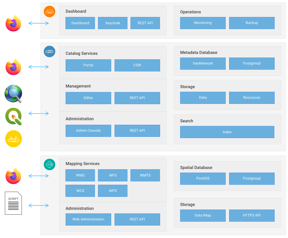 GeoCat Live Architecture
The main components of any Live service are software components that publish geospatial data through web services. GeoCat Live includes storage for storage for datasets (including file storage and a spatial database), and storage for dataset registrations.
Catalogue portal
The heart of GeoCat Live is the catalogue services offering portal for browsing, discovery and visualization of your spatial datasets.
 Portal visitors
The catalogue portal is intended for end-users and is the main entrance to the Live service when accessed through a browser. Users are able to query the catalogue and visualize the map services from the search result in an interactive mapping environment. The catalogue web interface is the main entrance to the Live service when accessed through a browser.
Web Services
The Open Geospatial Consortium has defined a series of standards, which are commonly used in the geospatial industry. For example the European INSPIRE directive to exchange environmental data is based on OGC standards.
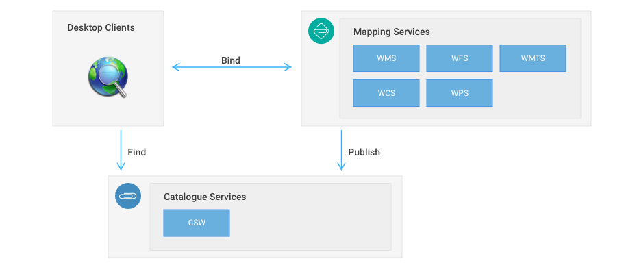 Publish find bind service architecture
These standards are intended for machine to machine communication and are used by Desktop GIS users and Web Developers.
OGC standards included in Live:
- Catalogue service for the Web (CSW) allows to search through dataset registrations (metadata records).
- Web Map Service provides access to data through rendered images.
- Web Map Tile service provides access to date through image or vector tiles following common gridsets.
- Web Feature Service (WFS) provides access to vector data.
- Web coverage Service (WCS) provides access to grid and multi-dimensional array data.
Client software is able to bind to OGC services. QGIS for example is able to query the catalogue (through its metasearch plugin) and is able to add data services advertised in the metadata on its map. OpenLayers, a common javascript mapping library, is able to display WMS and WFS services in a web environment.
The catalog component in Live includes a web client based on the OpenLayers library, which is able to query the catalogue and visualize the map services from the search result in an interactive mapping environment. The catalogue web interface is the main entrance to the Live service when accessed through a browser.
The Live service is maintained via the Live Dashboard and data is published using the Bridge client. The availability of any live service is constantly monitored, usage statistics are collected and backups are created. Reports of availability and usage are available in the Live Dashboard.
Data services
Spatial Database
Web services are supported by a PostGIS spatial database for processing and analysis.
Database access can be setup for direct publishing from Bridge, pgAdmin or your own scripts.
File storage
File storage is primarily used for raster contents in support of mapping services.
File storage access is available via WebDAV.
Dataset Records
Catalogue services are supported by a database for record storage, file storage (for any documents attached to catalogue records), a search index.
Management of these resources is available in the catalogue administrative console.
INSPIRE Validation
GeoCat Live premium customers have access to an INSPIRE Reference Validator that is not rate limited.
Security
GeoCat Live Standard customers make use of the built-in security module provided by Catalogue and Mapping service.
GeoCat Live Premium customers are supported in the use of their corporate security infrastructure:
- Using Open ID Connect (OIDC)
- Single sign on using Keycloak
- Direct integration with Catalogue services
- Direct integration with Mapping services