GeoCat Bridge
This article introduces specific aspects of publications to a Live service with the GeoCat Bridge publication tool.
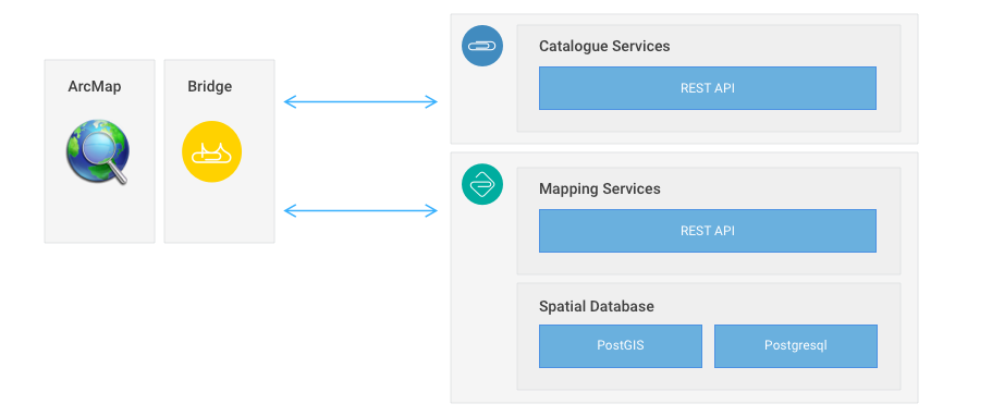
Bridge
The Bridge tool is a plugin for ArcMAP and QGIS, which is used to publish a map project to a GeoCat Live instance. Data will be uploaded, layers will be published as WMS and WFS or WCS services. The resulting datasets will be registered in the catalogue. Bi-directional links between catalogue and data services are created.
 ArcMap Bridge Publication
You can download the tool from the Bridge download page. The current ArcMap edition requires an activation key. A trial license can be ordered from the website and will be emailed to you. Any Live instance comes with a supplemental Bridge License. After registration to Live, consult support@geocat.com to receive your license. Check the Bridge documentation at https://docs.geocat.com/bridge for detailed installation instructions for your environment.
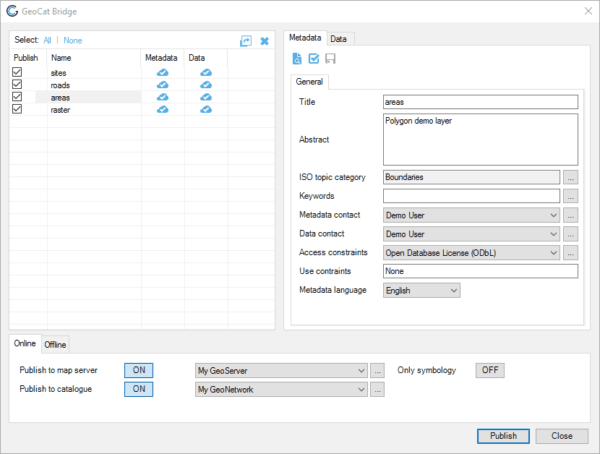
Bridge includes a wizard to connect the tool to your Live instance. Select the Live server type in the server configuration panel.
Fonts for map labels and icons
Live contains an extended set of fonts, including some of the common Windows symbol fonts. Check the GeoServer fonts page to see which fonts are available. These fonts can be used as labels in maps, as icons and as polygon fills. Bridge will verify if a font used in a symbology is available on the server and throw a warning if it is not available. Always take action on such a warning. The layer may be represented quite differently than on the desktop. Select an alternative font or use the resource browser in the GeoServer component to add additional fonts to your service. Verify that duplicating the font to our infrastructure does not infringe any copy or usage rights.
Managing file based data
Bridge is not able to remove data from any Live service. This means when you remove a data service from Live, you have to use the resource browser to remove related data files.
The resource browser is available in the GeoServer component. Log in as admin, open the resource browser and navigate to the data folder in the relevant workspace. Here you can remove any abundant data files. Be careful that you don't remove files which are used by existing layers.
Managing data in a database
At this point in time a default Live service does not expose a database port to the web.
This means that Live currently does not facilitate to upload data directly to the database. Instead you can let the GeoServer component in Live publish data from the transport format (GeoPackage) to PostGIS while creating a service for the data.